
A CERC pond being used for a sturgeon study is being mapped using an aDcp mounted on a River Ray.
Images
See our science through the images below.
Filter Total Items: 3543

Mapping A CERC Pond With A River Ray
A CERC pond being used for a sturgeon study is being mapped using an aDcp mounted on a River Ray.

Boat equipped with singlebeam sonar for mapping the bed of rivers
Boat equipped with singlebeam sonar for mapping the bed of riversBoat equipped with singlebeam sonar for mapping the bed of a river at shallow depths along the shoreline of the Colorado River.
Boat equipped with singlebeam sonar for mapping the bed of rivers
Boat equipped with singlebeam sonar for mapping the bed of riversBoat equipped with singlebeam sonar for mapping the bed of a river at shallow depths along the shoreline of the Colorado River.

Sorting Fish
Dave Walsh, Acting center Director, and Bob O'Gorman, fishery biologist sort the catch aboard the RV/Kaho in Lake Ontario.
By
Dave Walsh, Acting center Director, and Bob O'Gorman, fishery biologist sort the catch aboard the RV/Kaho in Lake Ontario.
By

RV Meteor
Oceanographic Research Vessel METEOR. Photo courtesy of Ferdinand Oberle.
Location: NW Iberian Shelf, Atlantic Ocean
Oceanographic Research Vessel METEOR. Photo courtesy of Ferdinand Oberle.
Location: NW Iberian Shelf, Atlantic Ocean
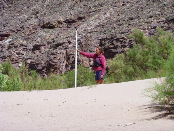
Surveying an exposed sandbar along the bank of the Colorado River
Surveying an exposed sandbar along the bank of the Colorado RiverSurveying an exposed sandbar along the bank of the Colorado River, Grand Canyon, May 2014. Photo by USGS, public domain.
Surveying an exposed sandbar along the bank of the Colorado River
Surveying an exposed sandbar along the bank of the Colorado RiverSurveying an exposed sandbar along the bank of the Colorado River, Grand Canyon, May 2014. Photo by USGS, public domain.

Pinyon-juniper and sagebrush on Juniper Mountain, NV
Pinyon-juniper and sagebrush on Juniper Mountain, NVPinyon-juniper and sagebrush on Juniper Mountain, Nevada.
Pinyon-juniper and sagebrush on Juniper Mountain, NV
Pinyon-juniper and sagebrush on Juniper Mountain, NVPinyon-juniper and sagebrush on Juniper Mountain, Nevada.

RV Meteor
Oceanographic Research Vessel METEOR.
Location: NW Iberian Shelf, Atlantic Ocean
Oceanographic Research Vessel METEOR.
Location: NW Iberian Shelf, Atlantic Ocean

Bottom Trawler Boat
One of the many passing bottom trawlers on the NW Iberian Shelf as seen from Research Vessel METEOR.
Location: NW Iberian Shelf, Atlantic Ocean
One of the many passing bottom trawlers on the NW Iberian Shelf as seen from Research Vessel METEOR.
Location: NW Iberian Shelf, Atlantic Ocean

Deploying Equipment from Oceanic Research Vessel
Deployment of Scientific Research Equipment (Tripod) from ship, RV Meteor
Location: NW Iberian Shelf, Atlantic Ocean
Deployment of Scientific Research Equipment (Tripod) from ship, RV Meteor
Location: NW Iberian Shelf, Atlantic Ocean

Onaqui SageStep field site, field camp
Field site truck and trailer at the Onaqui SageStep field site, field camp
Field site truck and trailer at the Onaqui SageStep field site, field camp

Sagebrush ecosystem in the winter.
Sagebrush ecosystem in the winter.

Sagebrush after juniper removal in Utah
Sagebrush after juniper removal in Utah.

Deer Island, Missouri River Restoration Site
Photo of restoration structures in the Deer Island restoration site, Missouri River, during April 2014.
Photo of restoration structures in the Deer Island restoration site, Missouri River, during April 2014.
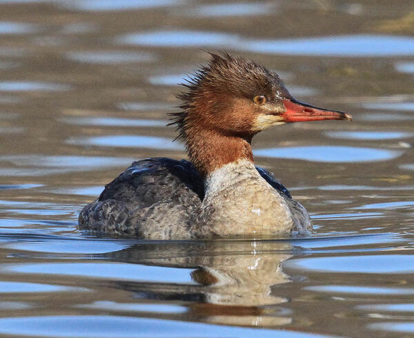
Female Common Merganser
Common Mergansers are sometimes called sawbills, fish ducks, or goosanders. The word “merganser” comes from the Latin and translates to “plunging goose”. Similar to Goldeneye ducks, mergansers usually nest in natural tree cavities.
Common Mergansers are sometimes called sawbills, fish ducks, or goosanders. The word “merganser” comes from the Latin and translates to “plunging goose”. Similar to Goldeneye ducks, mergansers usually nest in natural tree cavities.
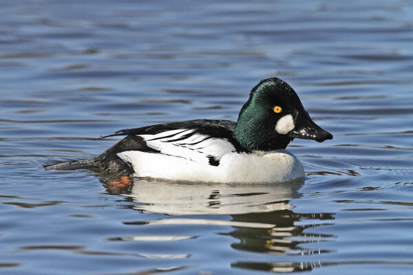
Male Common Goldeneye
The male Common Goldeneye performs a complex courtship display during winter and early spring. These diving ducks eat mostly aquatic invertebrates and fish and females nest in tree cavities.
The male Common Goldeneye performs a complex courtship display during winter and early spring. These diving ducks eat mostly aquatic invertebrates and fish and females nest in tree cavities.

Sea Lamprey Hammond Bay Biological Station
Sea Lamprey at the Hammond Bay Biological Statioin in Millersburg, MI
Sea Lamprey at the Hammond Bay Biological Statioin in Millersburg, MI

Carolina Northern Flying Squirrel
Radio-collared female Carolina Northern Flying Squirrel (Glaucomys sabrinus coloratus) in a high elevation red spruce (Picea rubens) stand on Whitetop Mountain, VA during winter of 2014.
Radio-collared female Carolina Northern Flying Squirrel (Glaucomys sabrinus coloratus) in a high elevation red spruce (Picea rubens) stand on Whitetop Mountain, VA during winter of 2014.

Sanderling (Calidris alba)
Sanderling (Calidris alba) walking on sand, seen during field work in Iceland in 2014.
Sanderling (Calidris alba) walking on sand, seen during field work in Iceland in 2014.

Cackling goose (Branta hutchinsii) on the Colville River Delta
Cackling goose (Branta hutchinsii) on the Colville River DeltaCackling goose (Branta hutchinsii) on the Colville River Delta. Photo by Ryan Askren, USGS.
Cackling goose (Branta hutchinsii) on the Colville River Delta
Cackling goose (Branta hutchinsii) on the Colville River DeltaCackling goose (Branta hutchinsii) on the Colville River Delta. Photo by Ryan Askren, USGS.

Glen Canyon Dam jet tubes releasing water for a high flow experiment
Glen Canyon Dam jet tubes releasing water for a high flow experimentGlen Canyon Dam jet tubes releasing water into the Colorado River for a high flow experiment. The increase in flow of the Colorado River downstream of the dam mobilizes sand at the bottom of the river and that sand rebuilds sandbars in Grand Canyon.