
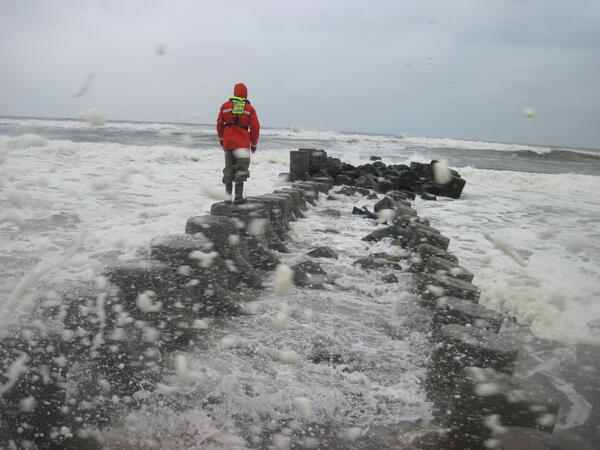
USGS scientist measuring high water marks on a jetty into the Long Island Sound during flooding in October of 2015.
Images
Explore water-related photography, imagery, and illustrations.
Filter Total Items: 2560
Simonson Joaquin 2015 10 03 AS 017 (1).JPG
USGS scientist measuring high water marks on a jetty into the Long Island Sound during flooding in October of 2015.

Recreation on the Frio River from overlook, Concan, Texas
Recreation on the Frio River from overlook, Concan, TexasPhotograph showing recreation on the Frio River from an overlook at Garner State Park, Concan, Texas. Published in Occurrence of Pharmaceutical Compounds in the San Antonio Segment of the Edwards (Balcones Fault Zone) Aquifer, South-Central Texas, June 2018–August 2020

Resolve low-level flight system
In this image, a helicopter towing a large, cylindrical sensor makes low-level flights as part of a USGS remote geophysical survey, which collects data about underground geology. The scientific system, called Resolve, is operated by CGG Canada Services, Ltd.
In this image, a helicopter towing a large, cylindrical sensor makes low-level flights as part of a USGS remote geophysical survey, which collects data about underground geology. The scientific system, called Resolve, is operated by CGG Canada Services, Ltd.

Flooding around Mill River streamflow gage 01171500 at Northampton, MA
Flooding around Mill River streamflow gage 01171500 at Northampton, MAFlooding around Mill River USGS streamflow gage 01171500 at Northampton, Massachusetts.
Flooding around Mill River streamflow gage 01171500 at Northampton, MA
Flooding around Mill River streamflow gage 01171500 at Northampton, MAFlooding around Mill River USGS streamflow gage 01171500 at Northampton, Massachusetts.

Harmful algal blooms turn water in Milford Lake emerald green
Harmful algal blooms turn water in Milford Lake emerald greenHarmful algal blooms turn water in Milford Lake emerald green
Harmful algal blooms turn water in Milford Lake emerald green
Harmful algal blooms turn water in Milford Lake emerald greenHarmful algal blooms turn water in Milford Lake emerald green

Hoover Dam looking upstream on the Colorado River.
Hoover Dam looking upstream on the Colorado River.Hoover Dam looking upstream on the Colorado River.
Hoover Dam looking upstream on the Colorado River.
Hoover Dam looking upstream on the Colorado River.Hoover Dam looking upstream on the Colorado River.

I-Beam and Sled ADVM Mount 2
A 4" aluminum I-beam is used allow an ADVM to be raised and lowered on a stainless steel sled. The I-beam also serves as a pedestal mount for electronics housing.
A 4" aluminum I-beam is used allow an ADVM to be raised and lowered on a stainless steel sled. The I-beam also serves as a pedestal mount for electronics housing.

USGS Deploys Crews to Site of Flash Flood
USGS crews are taking measurements following a flash flood event in Hildale, Utah.
USGS crews are taking measurements following a flash flood event in Hildale, Utah.

USGS Deploys Crews to Site of Flash Flood
USGS scientist Brad Slaugh measures streamflow following a flash flood event in Hildale, Utah.
USGS scientist Brad Slaugh measures streamflow following a flash flood event in Hildale, Utah.

USGS Deploys Crews to Site of Flash Flood
USGS scientist Brad Slaugh measures streamflow following a flash flood event in Hildale, Utah.
USGS scientist Brad Slaugh measures streamflow following a flash flood event in Hildale, Utah.

USGS Deploys Crews to Site of Flash Flood
USGS scientist Brad Slaugh taking measurements following a flash flood event in Hildale, Utah.
USGS scientist Brad Slaugh taking measurements following a flash flood event in Hildale, Utah.

Hallettsville, Texas Streamgage
A photo of the new USGS streamgage on the Lavaca River at Hallettsville, Texas.
A photo of the new USGS streamgage on the Lavaca River at Hallettsville, Texas.

Sediment Sampling at A72
Animas River downstream from Silverton, Colorado, showing right and left bank areas where streambed sediment sample was collected near USGS stream gage at site A72 (USGS site ID 09359020). Latitude 37.789964, Longitude -107.667394.
Animas River downstream from Silverton, Colorado, showing right and left bank areas where streambed sediment sample was collected near USGS stream gage at site A72 (USGS site ID 09359020). Latitude 37.789964, Longitude -107.667394.

Colorado River looking downstream, Imperial National Wildlife Refuge
Colorado River looking downstream, Imperial National Wildlife RefugeThe Colorado River at the Imperial National Wildlife Refuge near Cabin Lake, Arizona.
Colorado River looking downstream, Imperial National Wildlife Refuge
Colorado River looking downstream, Imperial National Wildlife RefugeThe Colorado River at the Imperial National Wildlife Refuge near Cabin Lake, Arizona.

Groundwater Sampling on Long Island
Groundwater Sampling on Long Island

Collecting data on coastal wetland on Long Island, NY
Collecting data on coastal wetland on Long Island, NYCollecting data on coastal wetland on Long Island, NY
Collecting data on coastal wetland on Long Island, NY
Collecting data on coastal wetland on Long Island, NYCollecting data on coastal wetland on Long Island, NY

San Angelo Streamgage
New streamgage on the South Concho river above Twin Buttes. This new gage will provide resource managers with critical streamflow information.
New streamgage on the South Concho river above Twin Buttes. This new gage will provide resource managers with critical streamflow information.

Measuring pH
Measuring pH at the outlet of the fourth settling pond downstream from the North Fork Cement Creek. Latitude 37.894451, Longitude -107.64763.
Measuring pH at the outlet of the fourth settling pond downstream from the North Fork Cement Creek. Latitude 37.894451, Longitude -107.64763.

USGS Gage 09358000
USGS stream Gage (USGS site ID 09358000) on Animas River upstream from Silverton and Cement Creek. Latitude 37.811131, Longitude -107.659213.
USGS stream Gage (USGS site ID 09358000) on Animas River upstream from Silverton and Cement Creek. Latitude 37.811131, Longitude -107.659213.

Animas River at A72
Animas River downstream from Silverton, Colorado showing cableway for USGS stream gage at site A72 (USGS site ID 09359020). Latitude 37.789964, Longitude -107.667394.
Animas River downstream from Silverton, Colorado showing cableway for USGS stream gage at site A72 (USGS site ID 09359020). Latitude 37.789964, Longitude -107.667394.

Animas River Downstream
Animas River downstream from Silverton Colorado, looking upstream toward town of Silverton. Confluence of Animas River and Mineral Creek near center of photograph. Confluence of Cement Creek and Animas River near upstream area of the town of Silverton. Photo taken from Highway 550 heading to Durango.
Animas River downstream from Silverton Colorado, looking upstream toward town of Silverton. Confluence of Animas River and Mineral Creek near center of photograph. Confluence of Cement Creek and Animas River near upstream area of the town of Silverton. Photo taken from Highway 550 heading to Durango.