
Streams and Rivers
Streams and Rivers
Filter Total Items: 119

National Water-Quality Project Sampling Methods
USGS National Water Quality Assessment (NAWQA) studies require analyses of stream and bed-sediment samples for major ions, nutrients, sediments, and organic contaminants that are consistent across time and space. Procedures have been designed specifically to produce information that is comparable among studies in different parts of the Nation.

Thermal Imaging Cameras for Studying Groundwater/Surface-Water Exchange
USGS scientists are using high-resolution handheld and airborne thermal imaging cameras in groundwater/surface-water exchange studies and other investigations where surface temperature contrasts indicate various hydrological processes. These cameras are used to quickly locate and characterize thermal (temperature) anomalies along streams, lakes, wetlands, estuaries, and across the landscape...

Fiber-Optic Distributed Temperature Sensing Technology for Surface-Water and Groundwater Studies
Fiber-optic distributed temperature sensing (FO-DTS) technology can be used for characterizing estuary-aquifer and stream-aquifer interaction and for identifying transmissive fractures in bedrock boreholes.
Geophysics for USGS Groundwater/Surface Water Exchange Studies
Locating and quantifying exchanges of groundwater and surface water, along with characterizing geologic structure, is essential to water-resource managers and hydrologists for the development of effective water-resource policy, protection, and management. The USGS conducts applied research to evaluate the use of new or emerging hydrogeophysical tools and methods to improve our understanding of...

Water Chemistry Data for Selected Springs, Geysers, and Streams in Yellowstone National Park, Wyoming, Beginning 2009
Results of water analyses conducted on numerous thermal and non-thermal features in Yellowstone National Park beginning in 2009. Water samples were collected and analyzed as part of research investigations on arsenic, iron, nitrogen, and sulfur redox species in hot springs and overflow drainages; the occurrence and distribution of dissolved mercury; and general hydrogeochemistry of hot springs.

Sequential, Time-Integrated Collector of Precipitation, Ground Water, and Surface Water for Analysis of Isotopes; US Patent 7,687,028
Patent for a sequential, time-integrated collector having an electronic controller that actuates either of two electrically-actuated valves, each connected to a water reservoir. (Full details provided by the U.S. Patent and Trademark Office website.)

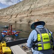
Colorado River Basin Focus Area Study
As one of several Focus Area Studies within the USGS National Water Census (NWC), the USGS has completed a 3-year study of water availability and use in the Colorado River Basin.

Water-Quality Trends
Is water quality getting better or worse? Answering this deceptively simple question has been a fundamental objective of the USGS National Water-Quality Assessment Project’s research. Learn about trends in contaminants in the nation’s streams and rivers, trends in contaminants that collect in the bed sediment of streams and lakes, and changes in the quality of the nation’s groundwater.

Sediment-Associated Contaminants
Stream, river, and lake bed sediment are reservoirs for many contaminants. These contaminants include some “legacy” contaminants, like DDT, PCBs, and chlordane, and chemicals currently in use, like the insecticide bifenthrin and many flame retardants. Learn about techniques used to study sediment-associated contaminants and their importance to aquatic biota.

Stream Ecology
Who lives in your stream? Rivers and streams, even small ones, are teeming with a vast number of species, including fish, aquatic invertebrates, and algae. Stream ecology is the study of those aquatic species, the way they interrelate, and their interactions with all aspects of these flowing water systems.

Gold King Mine release (2015): USGS water-quality data and activities
On August 5, 2015, U.S. EPA was conducting an investigation of the Gold King Mine near Silverton, Colorado. While excavating as part of the investigation, water began leaking from the mine tunnel, and about three million gallons of water and sediment were released into Cement Creek, a tributary of the Animas River. The USGS provided pre- and post-release water-quality and streamflow data from...