



Photograph of lava channels flowing from the base of the north vent lava fountain during episode 45 of lava fountaining in Halema‘uma‘u at the summit of Kīlauea on April 23, 2026. Episode 45 began just after 1 a.m. HST and ended about 8.5 hours later at 10:01 a.m. HST.
Images
Hawaiian Volcano Observatory images of eruptive activity, field work, and more.
Filter Total Items: 4244
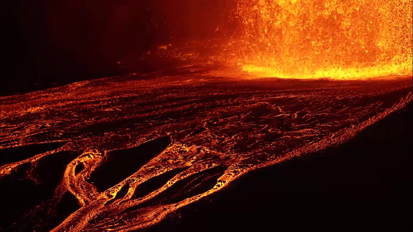
April 24, 2026 — Kīlauea episode 45 lava channels
Photograph of lava channels flowing from the base of the north vent lava fountain during episode 45 of lava fountaining in Halema‘uma‘u at the summit of Kīlauea on April 23, 2026. Episode 45 began just after 1 a.m. HST and ended about 8.5 hours later at 10:01 a.m. HST.
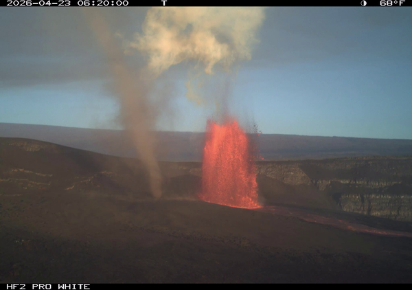
April 24, 2026 — Kīlauea episode 45 lava fountain and dust devil
April 24, 2026 — Kīlauea episode 45 lava fountain and dust devilThis image shows the north vent in Halema‘uma‘u erupting a lava fountain during episode 45 at Kīlauea summit on April 23, 2026, with a large dust devil, or puahiohio in ʻŌlelo Hawaiʻi, driven by heat rising from the hot lava flows, visible near the lava fountain. This image was captured by a timelapse camera located on the south rim of the caldera.
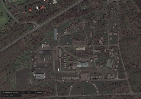
April 22, 2026 — Satellite image of Kilauea Military Camp
April 22, 2026 — Satellite image of Kilauea Military CampSatellite image of Kilauea Military Camp near Kīlauea summit in Hawaiʻi Volcanoes National Park taken on April 22, 2026, and showing tephra covering the ground and roofs. This area was affected by tephra deposition during lava fountaining episodes 43 (March 10, 2026) and 44 (April 9, 2026) at the summit of Kīlauea, in part due to wind conditions.
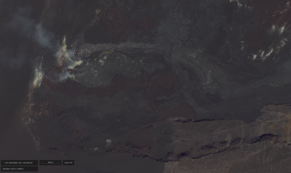
April 22, 2026 — Satellite image of eruptive vents in Halemaʻumaʻu at the summit of Kīlauea
April 22, 2026 — Satellite image of eruptive vents in Halemaʻumaʻu at the summit of KīlaueaSatellite image of the north and south vents in Halemaʻumaʻu at the summit of Kīlauea on April 22, 2026. Incandescent lava is visible in both vents, and episode 45 of lava fountaining started shortly later during the early morning hours of April 23, 2026. Image credit: WorldView ©2026 Maxar, USG Plus.
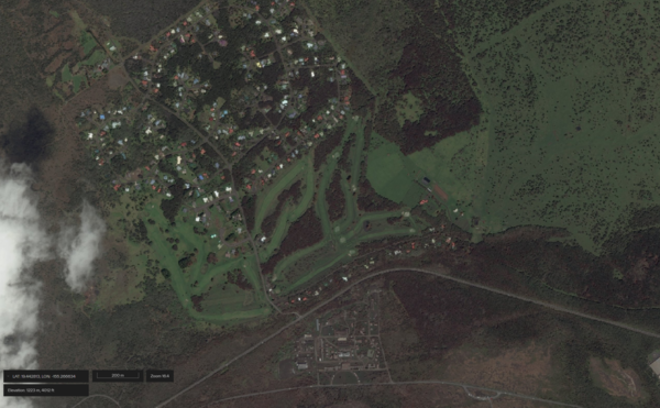
April 22, 2026 — Satellite image of Kilauea Military Camp and Volcano Golf Course
April 22, 2026 — Satellite image of Kilauea Military Camp and Volcano Golf CourseSatellite image of Kilauea Military Camp near Kīlauea summit in Hawaiʻi Volcanoes National Park and neighboring Volcano Golf Course subdivision taken on April 22, 2026, and showing tephra covering the ground and roofs.
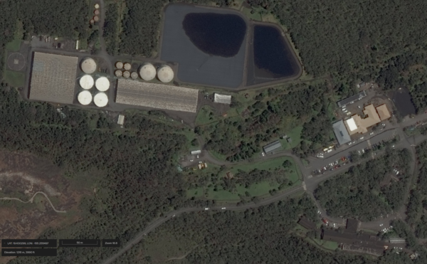
April 22, 2026 — Satellite image of Volcano House Hotel, Kīlauea Visitor Center, and infrastructure nearby
April 22, 2026 — Satellite image of Volcano House Hotel, Kīlauea Visitor Center, and infrastructure nearbySatellite image of Volcano House Hotel (lower right in image), Kīlauea Visitor Center (middle right in image), and neighboring infrastructure near Kīlauea summit in Hawaiʻi Volcanoes National Park taken on April 22, 2026.
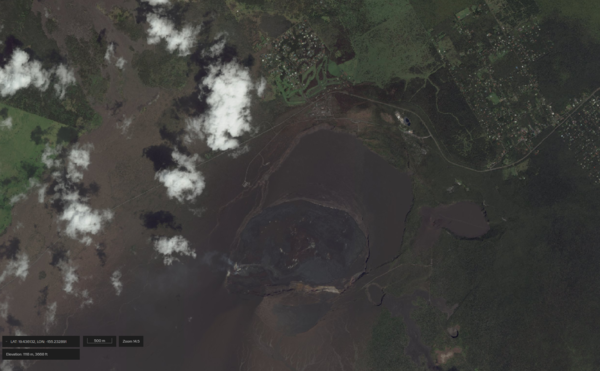
April 22, 2026 — Satellite image of Halemaʻumaʻu and Kaluapele at the summit of Kīlauea
April 22, 2026 — Satellite image of Halemaʻumaʻu and Kaluapele at the summit of KīlaueaSatellite image of Halemaʻumaʻu and Kaluapele at Kīlauea summit in Hawaiʻi Volcanoes National Park. Two eruptive vents (named the north and south vents) in Halemaʻumaʻu have been erupting lava fountains episodically since December 23, 2024. Forty-five episodes have occurred to date, depositing tephra around and in Kaluapele, and lava flows within Halemaʻumaʻu.

1926 Mauna Loa ‘a‘ā flow headed for Ho‘ōpūloa village
1926 Mauna Loa ‘a‘ā flow headed for Ho‘ōpūloa villageDuring the 1926 Mauna Loa eruption, an ‘a‘ā flow about 457 m (1500 ft) wide and 9 m (30 ft) high headed straight for the village of Ho‘ōpūloa on April 17, as shown here. By the next day, the lava flow had destroyed a dozen houses, a church, and the wharf, and had nearly obliterated the bay.
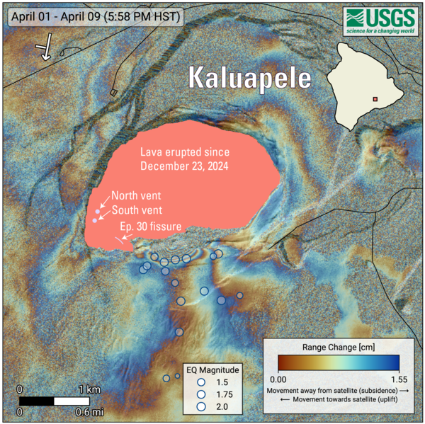
April 15, 2026—InSAR image of Kīlauea deformation associated with episode 44 of ongoing summit eruption
April 15, 2026—InSAR image of Kīlauea deformation associated with episode 44 of ongoing summit eruptionCOSMO-SkyMed Second Generation (CSG) interferogram for the period from April 1 to April 9, 2026, covering Kīlauea volcano’s summit region.
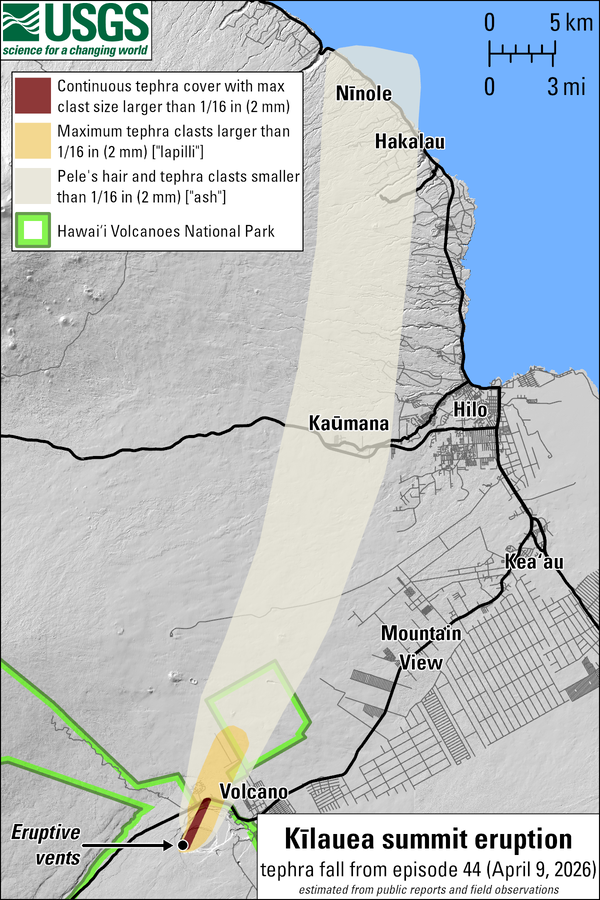
April 15, 2026—Summary map of tephra fall after episode 44 lava fountaining at the summit of Kīlauea
April 15, 2026—Summary map of tephra fall after episode 44 lava fountaining at the summit of KīlaueaThis map shows the tephra fall associated with episode 44 of Kīlauea's episodic summit eruption, on April 9, 2026. Tephra is a generic word for any material erupted by a volcano that travels through the air before landing on the ground.
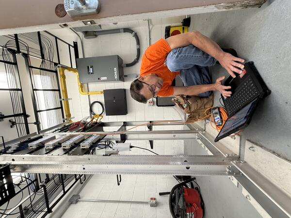
April 14, 2026 — HVO field engineer checks laptop
A USGS Hawaiian Volcano Observatory field engineer uses a field laptop to configure the connection between the new radio that was installed on the cell tower in Hawaiʻi Volcanoes National Park. This radio receives monitoring data via a radio link from another tower located at Uēkahuna, which collects data from various volcano-monitoring stations.
A USGS Hawaiian Volcano Observatory field engineer uses a field laptop to configure the connection between the new radio that was installed on the cell tower in Hawaiʻi Volcanoes National Park. This radio receives monitoring data via a radio link from another tower located at Uēkahuna, which collects data from various volcano-monitoring stations.
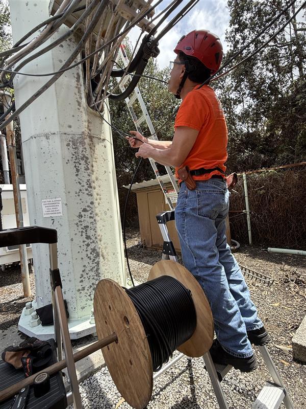
April 14, 2026 — HVO field engineer checks cables
A USGS Hawaiian Volcano Observatory field engineer checks cables at the base of a cell tower in Hawaiʻi Volcano National Park as part of a new point-to-point radio being installed. The previous point-to-point radio was damaged during recent storms, resulting in partial volcano-monitoring data outages since April 11, 2026.
A USGS Hawaiian Volcano Observatory field engineer checks cables at the base of a cell tower in Hawaiʻi Volcano National Park as part of a new point-to-point radio being installed. The previous point-to-point radio was damaged during recent storms, resulting in partial volcano-monitoring data outages since April 11, 2026.
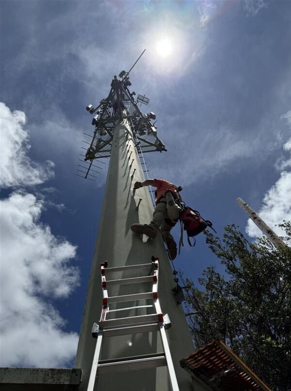
April 14, 2026 — HVO field engineer climbs tower
On Tuesday, April 14, 2026, USGS-Hawaiian Volcano Observatory field engineers with tower-climbing certifications ascended the cell tower within Hawaiʻi Volcano National Park.
On Tuesday, April 14, 2026, USGS-Hawaiian Volcano Observatory field engineers with tower-climbing certifications ascended the cell tower within Hawaiʻi Volcano National Park.
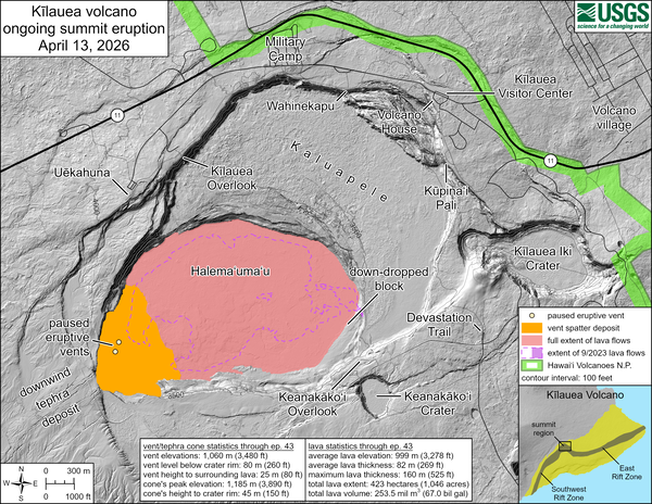
April 13, 2026—Kīlauea summit eruption reference map
April 13, 2026—Kīlauea summit eruption reference mapThis reference map depicts the Kīlauea summit eruption within Halema‘uma‘u crater that began on December 23, 2024. The data for this map were collected during a Hawaiian Volcano Observatory helicopter overflight on March 31, 2026; as such, the provided statistics are reflective of the first forty-three episodes of the eruption through March 10, 2026.
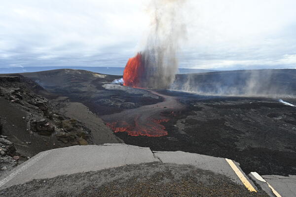
April 9, 2026 — Kīlauea summit eruption episode 44
April 9, 2026 — Kīlauea summit eruption episode 44Episode 44 of lava fountaining in Halemaʻumaʻu began at the summit of Kīlauea began at 11:10 a.m. HST on April 9, 2026. Precursory lava flows began on April 3, primarily from the south vent, and continued intermittently until the episode began. The predominant lava fountain during episode 44, however, came from the north vent.
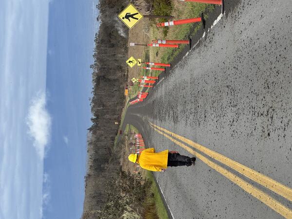
April 9, 2026 — Episode 44 tephra on Crater Rim Drive near Steaming Bluff
April 9, 2026 — Episode 44 tephra on Crater Rim Drive near Steaming BluffDuring lava fountaining episode 44 at the summit of Kīlauea, winds transported gas and tephra in a narrow band to the north-northeast of Halemaʻumaʻu. Tephra fallout was strongest in the direction of Kilauea Military Camp and the Volcano Golf Course subdivision, with pieces of lightweight reticulite up to 12 inches (30 centimeters) reported falling in these areas.
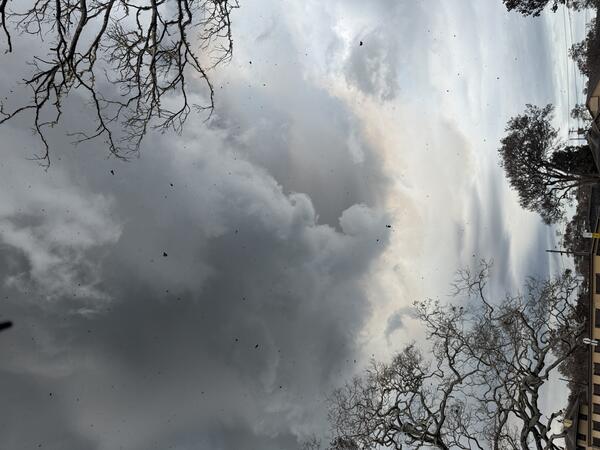
April 9, 2026 — Kīlauea summit eruption episode 44 plume and tephra falling
April 9, 2026 — Kīlauea summit eruption episode 44 plume and tephra fallingDuring episode 44 of lava fountaining at the summit of Kīlauea, the NOAA Washington Volcanic Ash Advisory Center reported the plume reached up to 16,000 feet (about 4,900 meters) above sea level. This photo shows the plume close the eruptive vents, and tephra is visibly falling through the air as the photo was taken. USGS photo by K. Mulliken.
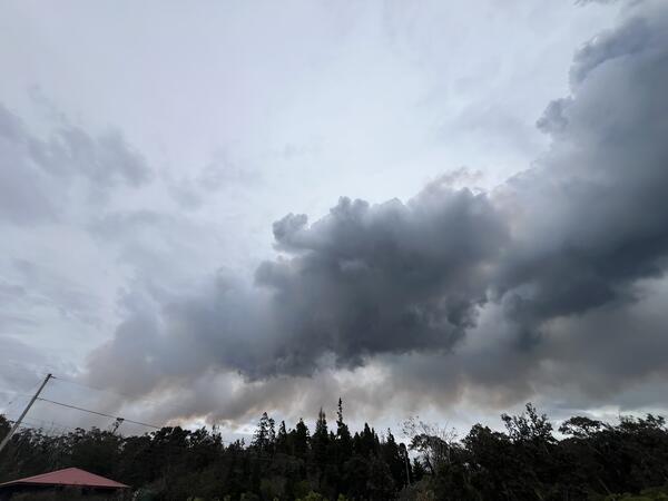
April 9, 2026 — Kīlauea episode 44 eruptive plume from Volcano village
April 9, 2026 — Kīlauea episode 44 eruptive plume from Volcano villageThe eruptive plume associated with episode 44 of lava fountaining at the summit of Kīlauea was transported by wind in a northeast direction. This photo shows the plume from Volcano village, about 4 miles (6.5 km) northeast of the eruptive vents in Hawaiʻi Volcanoes National Park. USGS photo by P. Dotray.
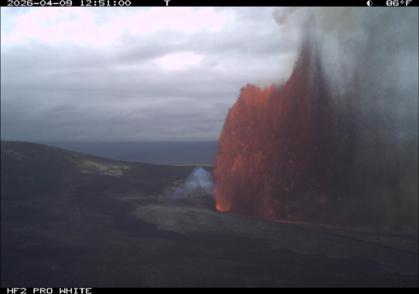
April 9, 2026 — Kīlauea episode 44 image from timelapse camera
April 9, 2026 — Kīlauea episode 44 image from timelapse cameraThis image shows Kīlauea summit eruption lava fountaining episode 44 on April 9, 2026. The image was captured by a USGS Hawaiian Volcano Observatory research camera on the south rim of the caldera. Although the south vent erupted most of the precursory lava flows, only the north vent erupted a lava fountain during the eruptive episode. USGS photo.
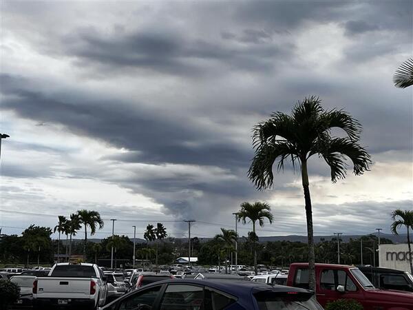
April 9, 2026 — Kīlauea episode 44 eruption plume from Hilo
April 9, 2026 — Kīlauea episode 44 eruption plume from HiloEpisode 44 at the summit of Kīlauea generated a plume of ash and gas, which strong southerly winds transported in a narrow band to the north-northeast of Halemaʻumaʻu, where it widened over a large section of east Hawaiʻi. This photo shows the eruption plume from Hilo, about 25 miles (40 km) to the northeast of the eruptive vents. USGS photo by C.
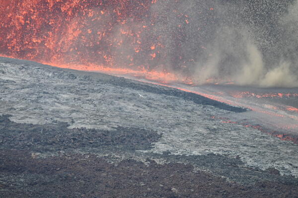
April 9, 2026 — Base of the north vent fountain during episode 44
April 9, 2026 — Base of the north vent fountain during episode 44This telephoto view, taken from the south rim of Halemaʻumaʻu crater, shows the base of the north vent lava fountain, which feeds a lava flow on to the crater floor during episode 44 on April 9, 2026. USGS photo by L. Gallant