




Sixty years of manned and unmanned space flight have left a cosmic junkyard circling the planet. In 2017, the U.S. government reported that it logged 308,984 close calls with space junk and issued 655 emergency-reportable alerts to satellite operators.
All Multimedia
Access all multimedia to include images, video, audio, webcams, before-after imagery, and more. Filter and explore with filtering options to refine search.
Filter Total Items: 24981
Sixty years of manned and unmanned space flight have left a cosmic junkyard circling the planet. In 2017, the U.S. government reported that it logged 308,984 close calls with space junk and issued 655 emergency-reportable alerts to satellite operators.

Landsat 8 image of Phoenix, Arizona
Landsat 8 image of Phoenix, Arizona, acquired on January 13, 2020 (Path 37 Row 36). This false color image uses the short-wave infrared, near infrared, and red bands (bands 6, 5, 4) to display the data.
For more information about Landsat, please visit www.usgs.gov/Landsat
Landsat 8 image of Phoenix, Arizona, acquired on January 13, 2020 (Path 37 Row 36). This false color image uses the short-wave infrared, near infrared, and red bands (bands 6, 5, 4) to display the data.
For more information about Landsat, please visit www.usgs.gov/Landsat

Image of the Week - An Aleutian Eruption, Day & Night
Image of the Week - An Aleutian Eruption, Day & NightThe Shishaldin Volcano on the eastern edge of Alaska's Aleutian Island chain erupted with activity in January of 2020. The eruption on the island of Unimak sent an ash cloud nearly 5 miles into the sky on January 7th, sparking ash alerts for aviators, mariners, and residents of nearby communities.
Image of the Week - An Aleutian Eruption, Day & Night
Image of the Week - An Aleutian Eruption, Day & NightThe Shishaldin Volcano on the eastern edge of Alaska's Aleutian Island chain erupted with activity in January of 2020. The eruption on the island of Unimak sent an ash cloud nearly 5 miles into the sky on January 7th, sparking ash alerts for aviators, mariners, and residents of nearby communities.

Installing a temporary seismometer
Photo (L-R) Jose Cancel of Puerto Rico Seismic Network (PRSN), Alena Leeds of USGS and Javier Santiago of PRSN install a temporary seismometer at Sabana Yeguas in southwestern Puerto Rico on Jan. 10, 2020.
Photo (L-R) Jose Cancel of Puerto Rico Seismic Network (PRSN), Alena Leeds of USGS and Javier Santiago of PRSN install a temporary seismometer at Sabana Yeguas in southwestern Puerto Rico on Jan. 10, 2020.

Imperial Geyser looking south, Yellowstone
Imperial Geyser hot spring pool in Yellowstone National Park is about 30 m (about 100 ft) across and contains alkaline-Cl waters with a steam vent in the pool and mudpots outside the pool area (in the upper right part of this photo). USGS Photo by Pat Shanks, 2019.
Imperial Geyser hot spring pool in Yellowstone National Park is about 30 m (about 100 ft) across and contains alkaline-Cl waters with a steam vent in the pool and mudpots outside the pool area (in the upper right part of this photo). USGS Photo by Pat Shanks, 2019.

Large microscope used for counting microplastics found in water sample
Large microscope used for counting microplastics found in water sampleLarge microscope used for counting microplastics found in water samples
Large microscope used for counting microplastics found in water sample
Large microscope used for counting microplastics found in water sampleLarge microscope used for counting microplastics found in water samples
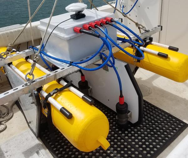
SQUID-5 - Structure-from-Motion Quantitative Underwater Imaging Device
SQUID-5 - Structure-from-Motion Quantitative Underwater Imaging DeviceThe SQUID-5, or a Structure-from-Motion (SfM) Quantitative Underwater Imaging Device with 5 cameras is a towed surface vehicle with an onboard Global Navigation Satellite System (GNSS) and 5 downward-looking cameras with overlapping views of the seafloor.
SQUID-5 - Structure-from-Motion Quantitative Underwater Imaging Device
SQUID-5 - Structure-from-Motion Quantitative Underwater Imaging DeviceThe SQUID-5, or a Structure-from-Motion (SfM) Quantitative Underwater Imaging Device with 5 cameras is a towed surface vehicle with an onboard Global Navigation Satellite System (GNSS) and 5 downward-looking cameras with overlapping views of the seafloor.

Visitors in the busy Old Faithful area
Visitors in the busy Old Faithful area. National Park Service photo by Neal Herbert, May 27, 2017.
Visitors in the busy Old Faithful area. National Park Service photo by Neal Herbert, May 27, 2017.

Image of the Week - Antarctica's Summer Solstice
It's winter in the northern hemisphere, but in Antarctica, summer has just begun. At Zucchelli Station the summer solstice occurred on December 22nd, 2019 at 5:19pm local time. The high temperature that day was a balmy 34 degrees Fahrenheit. These images from Landsat 8 show the distinct difference in sun angles cause by the change in seasons.
It's winter in the northern hemisphere, but in Antarctica, summer has just begun. At Zucchelli Station the summer solstice occurred on December 22nd, 2019 at 5:19pm local time. The high temperature that day was a balmy 34 degrees Fahrenheit. These images from Landsat 8 show the distinct difference in sun angles cause by the change in seasons.

Living with Earthquakes in Hawaii
Tens of thousands of earthquakes occur each year in Hawaii, making it one of the most seismically active places in the United States.
Tens of thousands of earthquakes occur each year in Hawaii, making it one of the most seismically active places in the United States.

Measuring streamflow through ice
Hydrologic technician Ryan Moore measures streamflow through ice at USGS streamgage station 13131000, Antelope Creek near Darlington, Idaho.
Hydrologic technician Ryan Moore measures streamflow through ice at USGS streamgage station 13131000, Antelope Creek near Darlington, Idaho.

Mountain Sunset over Susquehanna River, Pennsylvania
Mountain Sunset over Susquehanna River, PennsylvaniaMountain Sunset over Susquehanna River, Pennsylvania
Mountain Sunset over Susquehanna River, Pennsylvania
Mountain Sunset over Susquehanna River, PennsylvaniaMountain Sunset over Susquehanna River, Pennsylvania

Reported lionfish sightings from 1985 - January 8, 2020
Reported lionfish sightings from 1985 - January 8, 2020Reported lionfish sightings from 1985 - January 8, 2020
Data Source: U.S. Geological Survey, Nonindigenous Aquatic Species Database
Reported lionfish sightings from 1985 - January 8, 2020
Reported lionfish sightings from 1985 - January 8, 2020Reported lionfish sightings from 1985 - January 8, 2020
Data Source: U.S. Geological Survey, Nonindigenous Aquatic Species Database

Snowmobile Training Line-up
Lining up to finish our Snowmobile Safety Training class. Many of the roads we drive trucks on in the summer are inaccessible in the winter, so we must load up a machine.
Lining up to finish our Snowmobile Safety Training class. Many of the roads we drive trucks on in the summer are inaccessible in the winter, so we must load up a machine.

An Aleutian Eruption, Day and Night
The Shishaldin Volcano on the eastern edge of Alaska's Aleutian Island chain erupted with activity in January of 2020.
The Shishaldin Volcano on the eastern edge of Alaska's Aleutian Island chain erupted with activity in January of 2020.

Transitions: What's next for HVO and the volcanoes it monitors?
Transitions: What's next for HVO and the volcanoes it monitors?2018 and 2019 were years of profound change at Kīlauea Volcano and the USGS Hawaiian Volcano Observatory. Devastation caused by the largest lower East Rift Zone eruption and summit collapse in at least 200 years resulted in many transitions for island residents, including HVO.
Transitions: What's next for HVO and the volcanoes it monitors?
Transitions: What's next for HVO and the volcanoes it monitors?2018 and 2019 were years of profound change at Kīlauea Volcano and the USGS Hawaiian Volcano Observatory. Devastation caused by the largest lower East Rift Zone eruption and summit collapse in at least 200 years resulted in many transitions for island residents, including HVO.

Western sandpiper in San Francisco Bay
A Western sandpiper in San Francisco Bay.

A wave breaks over a degraded reef crest at Buck Island in St. Croix
A wave breaks over a degraded reef crest at Buck Island in St. CroixA wave breaking over a degraded reef crest at Buck Island National Monument in St. Croix. Wave-breaking in these habitats relies on reef framework built by the elkhorn coral, Acropora palmata, which is now a threatened species throughout the western Atlantic.
A wave breaks over a degraded reef crest at Buck Island in St. Croix
A wave breaks over a degraded reef crest at Buck Island in St. CroixA wave breaking over a degraded reef crest at Buck Island National Monument in St. Croix. Wave-breaking in these habitats relies on reef framework built by the elkhorn coral, Acropora palmata, which is now a threatened species throughout the western Atlantic.

How Our Reefs Protect Us: Valuing the Benefits of U.S. Reefs
How Our Reefs Protect Us: Valuing the Benefits of U.S. ReefsThe degradation of coastal habitats, particularly coral reefs, raises risks by increasing the exposure of coastal communities to flooding hazards during storms. The protective services of these natural defenses are not assessed in the same rigorous economic terms as artificial defenses, such as seawalls, and therefore often are not considered in decision-making.
How Our Reefs Protect Us: Valuing the Benefits of U.S. Reefs
How Our Reefs Protect Us: Valuing the Benefits of U.S. ReefsThe degradation of coastal habitats, particularly coral reefs, raises risks by increasing the exposure of coastal communities to flooding hazards during storms. The protective services of these natural defenses are not assessed in the same rigorous economic terms as artificial defenses, such as seawalls, and therefore often are not considered in decision-making.

Drone Pilots on a mission at Nelson Island Creek, Rowley, MA
Drone Pilots on a mission at Nelson Island Creek, Rowley, MAIn collaboration with the Marine Biological Laboratory (MBL) in Woods Hole, Massachusetts, the AIM group conducted UAS aerial surveys looking at vegetation classification/index surrounding a MBL gas flux tower located in Nelson Island Creek, Rowley, Massachusetts.
Drone Pilots on a mission at Nelson Island Creek, Rowley, MA
Drone Pilots on a mission at Nelson Island Creek, Rowley, MAIn collaboration with the Marine Biological Laboratory (MBL) in Woods Hole, Massachusetts, the AIM group conducted UAS aerial surveys looking at vegetation classification/index surrounding a MBL gas flux tower located in Nelson Island Creek, Rowley, Massachusetts.

Elizabeth Islands, Vineyard Sound, and Martha’s Vineyard.
Elizabeth Islands, Vineyard Sound, and Martha’s Vineyard.This image created using the Continuous Bathymetry and Elevation Models of the Massachusetts Coastal Zone and Continental Shelf, shows the Elizabeth Islands, Vineyard Sound, and Martha’s Vineyard.
Elizabeth Islands, Vineyard Sound, and Martha’s Vineyard.
Elizabeth Islands, Vineyard Sound, and Martha’s Vineyard.This image created using the Continuous Bathymetry and Elevation Models of the Massachusetts Coastal Zone and Continental Shelf, shows the Elizabeth Islands, Vineyard Sound, and Martha’s Vineyard.