
USGS Earth Resources Observation and Science (EROS) Center scientists Heather Tollerud, Terry Sohl, Jennifer Rover and Jon Dewitz use the LCMAP Timeseries Analysis and Plotting Tool (TAPTool) during a November 2018 workshop on Land Change Monitoring, Assessment, and Projection in Sioux Falls, SD.
Images
Explore our planet through photography and imagery, including climate change and water all the way back to the 1800s when the USGS was surveying the country by horse and buggy.
Filter Total Items: 21343

USGS EROS Scientists at LCMAP workshop
USGS Earth Resources Observation and Science (EROS) Center scientists Heather Tollerud, Terry Sohl, Jennifer Rover and Jon Dewitz use the LCMAP Timeseries Analysis and Plotting Tool (TAPTool) during a November 2018 workshop on Land Change Monitoring, Assessment, and Projection in Sioux Falls, SD.

Video camera setup at Isla Verde
Shawn Harrison stands near video cameras on top of a building overlooking Isla Verde in San Juan, Puerto Rico. The cameras measure wave run-up and flooding as part of a study in response to Hurricane Irma and Hurricane Maria.
Shawn Harrison stands near video cameras on top of a building overlooking Isla Verde in San Juan, Puerto Rico. The cameras measure wave run-up and flooding as part of a study in response to Hurricane Irma and Hurricane Maria.

Zhe Zhu and Curtis Woodcock at LCMAP workshop
Texas Tech University's Zhe Zhu and Boston University's Curtis Woodcock at a November 2018 workshop on Land Change Monitoring, Assessment, and Projection at the Earth Resources Observation and Science (EROS) Center in Sioux Falls, SD.
Texas Tech University's Zhe Zhu and Boston University's Curtis Woodcock at a November 2018 workshop on Land Change Monitoring, Assessment, and Projection at the Earth Resources Observation and Science (EROS) Center in Sioux Falls, SD.

Isla Verde, San Juan, Puerto Rico
The urban reef at Isla Verde supports various species of protected corals, sea turtles, and crustaceans, as well as many Caribbean fish. It also protects the International Airport and numerous homes and resorts on the coast.
The urban reef at Isla Verde supports various species of protected corals, sea turtles, and crustaceans, as well as many Caribbean fish. It also protects the International Airport and numerous homes and resorts on the coast.

RestoreNet treatments
RestoreNet locations are testing commonly used restoration techniques, including pitting, mulching, and above-ground micro sites. Here, metal crosses create an above-ground microsite that can increase soil moisture by providing shade and collecting debris under some conditions.
RestoreNet locations are testing commonly used restoration techniques, including pitting, mulching, and above-ground micro sites. Here, metal crosses create an above-ground microsite that can increase soil moisture by providing shade and collecting debris under some conditions.

RestoreNet treatments
RestoreNet locations are testing commonly used restoration techniques, including pitting, mulching, and above-ground micro sites. This photo shows the mulching treatment, which can increase soil moisture and lead to higher plant survival under some conditions.
RestoreNet locations are testing commonly used restoration techniques, including pitting, mulching, and above-ground micro sites. This photo shows the mulching treatment, which can increase soil moisture and lead to higher plant survival under some conditions.

RestoreNet treatments
RestoreNet locations are testing commonly used restoration techniques, including pitting, mulching, and above-ground micro sites. Here, pits have filled with water, illustrating how this technique increases soil moisture by capturing rainwater.
RestoreNet locations are testing commonly used restoration techniques, including pitting, mulching, and above-ground micro sites. Here, pits have filled with water, illustrating how this technique increases soil moisture by capturing rainwater.

Survey at a dam-removal and culvert-retrofit site
USGS staff survey the Mill River near the former Hopewell Mills Dam site in Taunton, Massachusetts. Surveys at the dam-removal and culvert-retrofit sites provided topographic and bathymetric data for hydraulic models developed for the study.
USGS staff survey the Mill River near the former Hopewell Mills Dam site in Taunton, Massachusetts. Surveys at the dam-removal and culvert-retrofit sites provided topographic and bathymetric data for hydraulic models developed for the study.

A broken slab is all that's left of Fish Inn after Hurricane Michael
A broken slab is all that's left of Fish Inn after Hurricane MichaelA broken concrete foundation and some shattered floor tiles were all that remained of the sea turtle researchers' field station and home base after Category Four Hurricane Michael struck Cape San Blas on Oct. 10, 2018.

View into fissure 8 cone in Kīlauea Volcano's lower East Rift Zone
View into fissure 8 cone in Kīlauea Volcano's lower East Rift ZoneView into fissure 8 cone in Kīlauea Volcano's lower East Rift Zone, after lava drained away.
View into fissure 8 cone in Kīlauea Volcano's lower East Rift Zone
View into fissure 8 cone in Kīlauea Volcano's lower East Rift ZoneView into fissure 8 cone in Kīlauea Volcano's lower East Rift Zone, after lava drained away.

NJ tide site
Northeast Region Photo Contest Winner | November 2018 | Honorable Mention
NJ tide site
Northeast Region Photo Contest Winner | November 2018 | Honorable Mention
NJ tide site
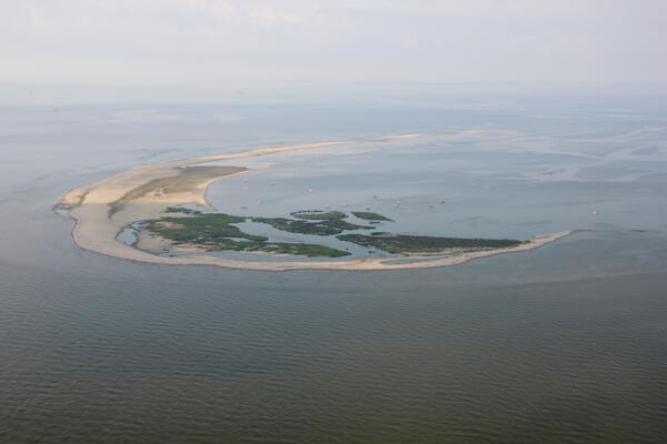
Aerial photograph looking southwest along Breton Island, Louisiana
Aerial photograph looking southwest along Breton Island, LouisianaAerial photograph looking southwest along Breton Island, Louisiana, taken July 2013
Aerial photograph looking southwest along Breton Island, Louisiana
Aerial photograph looking southwest along Breton Island, LouisianaAerial photograph looking southwest along Breton Island, Louisiana, taken July 2013

An HVO geologist walks along the summit trail, with Mauna Kea in the background.
An HVO geologist walks along the summit trail, with Mauna Kea in the background.An HVO geologist walks along the summit trail, with Mauna Kea in the background.
An HVO geologist walks along the summit trail, with Mauna Kea in the background.
An HVO geologist walks along the summit trail, with Mauna Kea in the background.An HVO geologist walks along the summit trail, with Mauna Kea in the background.

Channel Islands National Park from an aerial photographic survey
Channel Islands National Park from an aerial photographic surveyView of Channel Islands National Park from a Fall 2018 aerial photographic survey.
The Seabird Studies Team at the USGS Western Ecological Research Center is conducting aerial photographic surveys of the ocean off central and southern California to create comprehensive maps of seabird and marine mammal distributions.

GLSC Greenhouse
GLSC’s Aaron DeVries and Mckenzie Smith, left, discuss innovative controls for invasive Phragmites australis in GLSC’s greenhouse facility.
GLSC’s Aaron DeVries and Mckenzie Smith, left, discuss innovative controls for invasive Phragmites australis in GLSC’s greenhouse facility.

Laurel formation in Washington East quad examined by Wayne Newell
Laurel formation in Washington East quad examined by Wayne NewellNortheast Region Photo Contest Winner | November 2018 | Honorable Mention
Laurel formation in Washington East quad examined by Wayne Newell
Laurel formation in Washington East quad examined by Wayne Newell
Laurel formation in Washington East quad examined by Wayne NewellNortheast Region Photo Contest Winner | November 2018 | Honorable Mention
Laurel formation in Washington East quad examined by Wayne Newell

Tungsten
Photo Contest Winner | March 2020 | Honorable Mention 1
Critical mineral - tungsten
Photo Contest Winner | March 2020 | Honorable Mention 1
Critical mineral - tungsten

Wave-tide gauge off San Juan
Wave-tide gauge, pictured here on a coral reef amongst sea rods, brain corals, and sea fans, installed off Isla Verde in San Juan, Puerto Rico.
Wave-tide gauge, pictured here on a coral reef amongst sea rods, brain corals, and sea fans, installed off Isla Verde in San Juan, Puerto Rico.

Webcam check at Halema‘uma‘u
HVO geologists made a routine visit to the webcam monitoring Halema‘uma‘u. No changes were observed in the pit, but views were hampered by poor weather and thick fog.
HVO geologists made a routine visit to the webcam monitoring Halema‘uma‘u. No changes were observed in the pit, but views were hampered by poor weather and thick fog.

Acoustic Doppler Current Profiler (ADCP) boat measurement
Acoustic Doppler Current Profiler (ADCP) boat measurementNortheast Region Photo Contest Winner | June 2019 | Where We Work
Getting ready to begin an Acoustic Doppler Current Profiler (ADCP) boat measurement at 01457500 Delaware River at Riegelsville, NJ

Endicott Island, Alaska
Endicott Island, and artificial island built in 1987 by Alaska Interstate Construction and is used by BP and Hilcorp Alaska for petroleum production.
Endicott Island, and artificial island built in 1987 by Alaska Interstate Construction and is used by BP and Hilcorp Alaska for petroleum production.