
Maumee River at Antwerp, OH - pipes running into the river that contain the water-qualityy equipment probes
Images
Explore our planet through photography and imagery, including climate change and water all the way back to the 1800s when the USGS was surveying the country by horse and buggy.
Filter Total Items: 21343

Maumee River at Antwerp, OH - equipment pioes
Maumee River at Antwerp, OH - pipes running into the river that contain the water-qualityy equipment probes

Surveying for the FEMA project
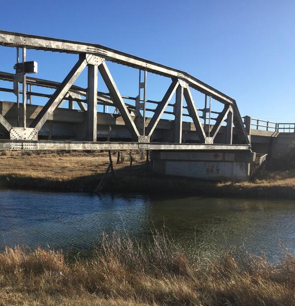
Sam Banas using a total station to survey points on the covered bridge that is located along the Tioga River in the Belmont, New Hampshire. These survey points will be used in the Winnipesaukee Watershed flood risk analysis mapping project funded by FEMA as part of the National Flood Insurance Program.
Sam Banas using a total station to survey points on the covered bridge that is located along the Tioga River in the Belmont, New Hampshire. These survey points will be used in the Winnipesaukee Watershed flood risk analysis mapping project funded by FEMA as part of the National Flood Insurance Program.

Upper terrace of Mud Creek slide
Mud Creek slide from south side of north upper terrace (above north and south berms). Note tension cracks and offset on the terrace to the north.
Mud Creek slide from south side of north upper terrace (above north and south berms). Note tension cracks and offset on the terrace to the north.

Mount St. Helens as viewed from the ENE.
Mount St. Helens, as viewed from the East-Northeast. The inside of the crater rim is just visible in the upper right of the mountain.
Mount St. Helens, as viewed from the East-Northeast. The inside of the crater rim is just visible in the upper right of the mountain.

Collaborative Discussion
The USGS RAMPS program hosts workshops where land managers from federal, state, and local agencies, practitioners, and NGO's can come together to discuss challenges and develop creative solutions.
The USGS RAMPS program hosts workshops where land managers from federal, state, and local agencies, practitioners, and NGO's can come together to discuss challenges and develop creative solutions.

Emperor geese near Kodiak.
Emperor geese gathered near the shoreline on Kodiak Island.
Emperor geese gathered near the shoreline on Kodiak Island.

Field survey methods
Photos of survey equipment used during surveys of the Elwha River delta, Washington, from 2010-2017, showing:
Photos of survey equipment used during surveys of the Elwha River delta, Washington, from 2010-2017, showing:

School Branch at Maloney Road near Brownsburg IN - solar panel at gage
School Branch at Maloney Road near Brownsburg IN - solar panel at gageSchool Branch at Maloney Road near Brownsburg IN - solar panel at gage
School Branch at Maloney Road near Brownsburg IN - solar panel at gage
School Branch at Maloney Road near Brownsburg IN - solar panel at gageSchool Branch at Maloney Road near Brownsburg IN - solar panel at gage

School Branch at Maloney Road near Brownsburg IN - stagnant water
School Branch at Maloney Road near Brownsburg IN - stagnant waterSchool Branch at Maloney Road near Brownsburg IN - gage house
School Branch at Maloney Road near Brownsburg IN - stagnant water
School Branch at Maloney Road near Brownsburg IN - stagnant waterSchool Branch at Maloney Road near Brownsburg IN - gage house

This single-celled alga is a natural ornament
It looks like a holiday ornament, but this lovely object is a single-celled freshwater alga from the desmid family, found in the marshes of Florida’s Arthur R. Marshall Loxahatchee National Wildlife Refuge. USGS biologist Barry Rosen photographed it at 200x magnification using ultraviolent light and a fluorescence microscope.
It looks like a holiday ornament, but this lovely object is a single-celled freshwater alga from the desmid family, found in the marshes of Florida’s Arthur R. Marshall Loxahatchee National Wildlife Refuge. USGS biologist Barry Rosen photographed it at 200x magnification using ultraviolent light and a fluorescence microscope.

Well pumping as part of an aquifer test in Lovelock Valley, Nevada
Well pumping as part of an aquifer test in Lovelock Valley, NevadaWell pumping as part of an aquifer test in Lovelock Valley, Nevada.
Well pumping as part of an aquifer test in Lovelock Valley, Nevada
Well pumping as part of an aquifer test in Lovelock Valley, NevadaWell pumping as part of an aquifer test in Lovelock Valley, Nevada.

Filtration system used for processing samples
Filtration system used for processing samples using a technique called polymerase chain reaction (PCR) or quantitative PCR (qPCR).
Filtration system used for processing samples using a technique called polymerase chain reaction (PCR) or quantitative PCR (qPCR).
Wire weight mounted on bridge crossing Blacks Fork, streamgage 0921920
Wire weight mounted on bridge crossing Blacks Fork, streamgage 0921920Wire weight mounted on bridge crossing Blacks Fork, streamgage 09219200
Wire weight mounted on bridge crossing Blacks Fork, streamgage 0921920
Wire weight mounted on bridge crossing Blacks Fork, streamgage 0921920Wire weight mounted on bridge crossing Blacks Fork, streamgage 09219200

Black River at Elyria, OH - bank side
Black River at Elyria, OH - bank side

Black River at Elyria, OH - view from the river bank
Black River at Elyria, OH - view from the river bankBlack River at Elyria, OH - view from the river bank
Black River at Elyria, OH - view from the river bank
Black River at Elyria, OH - view from the river bankBlack River at Elyria, OH - view from the river bank

Hydrogeologic Framework Mapping - Long Island
Hydrogeologic Framework Mapping - Long Island
Hydrogeologic Framework Mapping - Long Island

StonyBrook gage
Stony Brook at Princeton (01401000) Gage House as seen from across the Creek.
Stony Brook at Princeton (01401000) Gage House as seen from across the Creek.

Yellow Creek near Oak Grove, IN - downstream of bridge
Yellow Creek near Oak Grove, IN - downstream of bridgeYellow Creek near Oak Grove, IN - downstream of bridge
Yellow Creek near Oak Grove, IN - downstream of bridge
Yellow Creek near Oak Grove, IN - downstream of bridgeYellow Creek near Oak Grove, IN - downstream of bridge

What do we call new land at Kīlauea's ocean entries?
What do we call new land at Kīlauea's ocean entries?Kīlauea Volcano's Kamokuna lava delta on October 6, 2017. Multiple streams of lava entering the ocean on both sides of the delta created small plumes of laze (lava haze). The visible part of the delta, which is deceptively stable, was built by many small lava flows accumulating on an unstable foundation of unconsolidated volcanic rock fragments. USGS photo by L.

Typical lava lake activity at Kīlauea's summit
Kīlauea Volcano's summit lava lake activity over the past few days has been typical, with intermittent sites of spattering and migration of the crust from north to south (top to bottom of image). This view of the lava lake was captured on the evening of Saturday, November 18.
Kīlauea Volcano's summit lava lake activity over the past few days has been typical, with intermittent sites of spattering and migration of the crust from north to south (top to bottom of image). This view of the lava lake was captured on the evening of Saturday, November 18.

East Fork Whitewater River at Richmond IN - view of left bank
East Fork Whitewater River at Richmond IN - view of left bankEast Fork Whitewater River at Richmond IN - view of left bank at the gage
East Fork Whitewater River at Richmond IN - view of left bank
East Fork Whitewater River at Richmond IN - view of left bankEast Fork Whitewater River at Richmond IN - view of left bank at the gage