
Map of Long Bay, S.C. study area
Images
Coastal and Marine Hazards and Resources Program images.
Filter Total Items: 2420

Study area map of Long Bay, S.C.

Study area map of coastal South Carolina
Study area map of coastal South Carolina
Study area map of coastal South Carolina

PCMSC Magnetometer
USGS Pacific Coastal and Marine Science Center field crew showing off the new magnetometer, named Magnetron, on fantail of Research Vessel (R/V) Parke Snavely.
USGS Pacific Coastal and Marine Science Center field crew showing off the new magnetometer, named Magnetron, on fantail of Research Vessel (R/V) Parke Snavely.

Stellwagen Bank project research sites in the United States and Canada
Stellwagen Bank project research sites in the United States and CanadaStellwagen Bank project research areas in the United States and Canada
Stellwagen Bank project research sites in the United States and Canada
Stellwagen Bank project research sites in the United States and CanadaStellwagen Bank project research areas in the United States and Canada

Map of Fire Island, N.Y. study area
Map of Fire Island, N.Y. study area
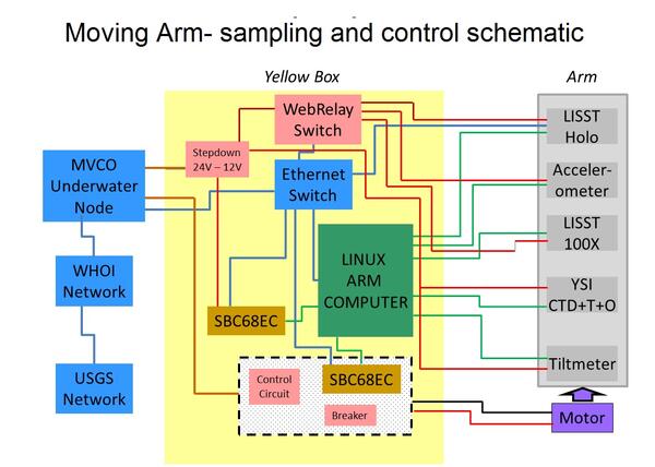
Schematic of system designed to control movement and logging of data
Schematic of system designed to control movement and logging of dataSchematic of system designed to control movement and logging of data collected by the Moving Arm Tripod at Martha's Vineyard Coastal Observatory in 2011.
Schematic of system designed to control movement and logging of data
Schematic of system designed to control movement and logging of dataSchematic of system designed to control movement and logging of data collected by the Moving Arm Tripod at Martha's Vineyard Coastal Observatory in 2011.

Bathymetry of the New England inner shelf and south shore of Martha’s
Bathymetry of the New England inner shelf and south shore of Martha’sBathymetry of the New England inner shelf and south shore of Martha’s Vineyard with model grids
Bathymetry of the New England inner shelf and south shore of Martha’s
Bathymetry of the New England inner shelf and south shore of Martha’sBathymetry of the New England inner shelf and south shore of Martha’s Vineyard with model grids

Ammonite fossil in Washington DC office building
Susan Russell-Robinson points out a fossil ammonite in the limestone floor tiles of the Eisenhower Executive Office Building in Washington, D.C.
Susan Russell-Robinson points out a fossil ammonite in the limestone floor tiles of the Eisenhower Executive Office Building in Washington, D.C.


R/V Parke Snavely in Alviso Slough
USGS Pacific Coastal and Marine Science Center's research vessel R/V Parke Sanvely motors through Alviso Slough in the southern end of San Francisco Bay. Scientists were collecting depth data to make a detailed bathymetric map of the Bay.
USGS Pacific Coastal and Marine Science Center's research vessel R/V Parke Sanvely motors through Alviso Slough in the southern end of San Francisco Bay. Scientists were collecting depth data to make a detailed bathymetric map of the Bay.

Oceanographic equipment customized to reach the benthic boundary layer
Oceanographic equipment customized to reach the benthic boundary layerSteaming to the deployment site south of Martha's Vineyard, MA in 2011. The platform shown was specially adapted so the arm cycles up and down through the Benthic Boubdary Layer while deployed on the seafloor. For more information see https://soundwaves.usgs.gov/2011/11/fieldwork2.html.

Arctic Ice Conditions
Ice conditions in the Arctic from CCGS Louis S. St-Laurent.
Ice conditions in the Arctic from CCGS Louis S. St-Laurent.

USGS scientists test the moving arm bottom platform
USGS scientists test the moving arm bottom platformUSGS scientists test the moving arm bottom platform at the Woods Hole Oceanographic Institution (WHOI) dock. While it was deployed, the system moved sensors through the bottom boundary layer and transmitted data in real time to shore via WHOI's Martha's Vineyard coastal observatory.

USGS scientists assembling a novel profiling arm
USGS scientists assembling a novel profiling arm to measure suspended sediment in the benthic boundary layer. This large seafloor platform was later deployed for several months off Martha's Vineyard, MA as part of the Optics Acoustics and Stress In Situ (OASIS) Project in 2011.
USGS scientists assembling a novel profiling arm to measure suspended sediment in the benthic boundary layer. This large seafloor platform was later deployed for several months off Martha's Vineyard, MA as part of the Optics Acoustics and Stress In Situ (OASIS) Project in 2011.

Photo of the beach state after Hurricane Irene
Post Hurricane Irene: Beach state after Hurricane Irene showing the exposure of a groin from loss of beach elevation (foreground) and beach and dune scarping due to elevated water levels (background).
Post Hurricane Irene: Beach state after Hurricane Irene showing the exposure of a groin from loss of beach elevation (foreground) and beach and dune scarping due to elevated water levels (background).

Sand eroded from the beach and dunes was transported landward
Sand eroded from the beach and dunes was transported landwardDuring Hurricane Irene, sand eroded from the beach and dunes was transported landward, burying a walkway near the Fire Island lighthouse.
Sand eroded from the beach and dunes was transported landward
Sand eroded from the beach and dunes was transported landwardDuring Hurricane Irene, sand eroded from the beach and dunes was transported landward, burying a walkway near the Fire Island lighthouse.

Camera sled deployment off research vessel
U.S. Geological Survey geographer Nadine Golden (center, kneeling) works with USGS marine operations staffer Cordell Johnson (right) and a deckhand (left) to deploy a camera sled from the research vessel Coral Sea. The sled is towed close to the seafloor and collects real-time photographs and videos.
U.S. Geological Survey geographer Nadine Golden (center, kneeling) works with USGS marine operations staffer Cordell Johnson (right) and a deckhand (left) to deploy a camera sled from the research vessel Coral Sea. The sled is towed close to the seafloor and collects real-time photographs and videos.

Oblique aerial photograph near Rodanthe, North Carolina, Aug. 30, 2011
Oblique aerial photograph near Rodanthe, North Carolina, Aug. 30, 2011Oblique aerial photograph near Rodanthe, North Carolina, looking south along the coast on August 30, 2011, three days after landfall of Hurricane Irene.
Oblique aerial photograph near Rodanthe, North Carolina, Aug. 30, 2011
Oblique aerial photograph near Rodanthe, North Carolina, Aug. 30, 2011Oblique aerial photograph near Rodanthe, North Carolina, looking south along the coast on August 30, 2011, three days after landfall of Hurricane Irene.

Airgun array deployment
Deploying the airgun array from CCGS Louis S. St-Laurent. USCGC Healy can be seen in the background.
Deploying the airgun array from CCGS Louis S. St-Laurent. USCGC Healy can be seen in the background.

Multichannel seismic sled being deployed off ship
The airgun sled is painted orange and suspended from the A-frame. The three airguns are suspended beneath the sled. The multichannel digital streamer (yellow cable going into the water from the sled) is towed from the the weighted sled to keep it under the ice. This photo shows the number of crew required to safely deploy the airgun sled.
The airgun sled is painted orange and suspended from the A-frame. The three airguns are suspended beneath the sled. The multichannel digital streamer (yellow cable going into the water from the sled) is towed from the the weighted sled to keep it under the ice. This photo shows the number of crew required to safely deploy the airgun sled.

Ice Breaker
CCGS Louis S. St-Laurent following the path created by USCGC Healy
CCGS Louis S. St-Laurent following the path created by USCGC Healy