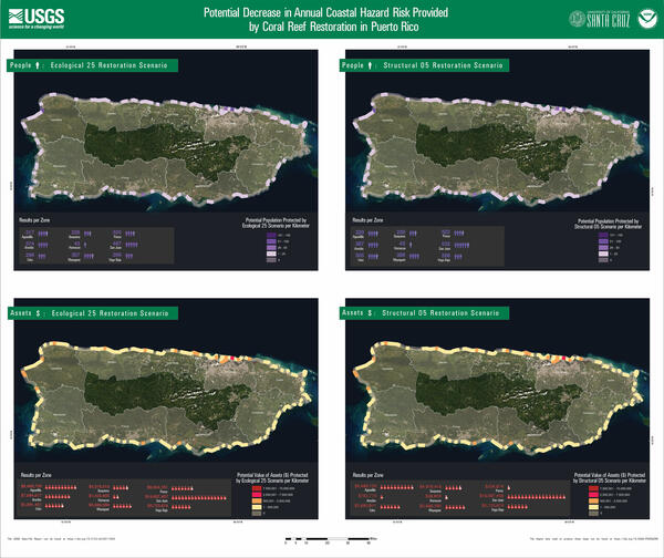
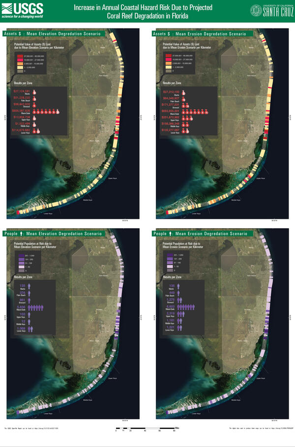
U.S. flag

An official website of the United States government

Images

Coastal and Marine Hazards and Resources Program images.

Filter Total Items: 2397
Folleto con texto y una vista aérea mirando hacia abajo en una costa con puntos que representan valores de datos en la costa.
Beneficios sociales y económicos de la restauración: Puerto Rico 2

La restauración de los arrecifes de coral puede producir beneficios significativos en la reducción de inundaciones. Estas defensas naturales sufrieron daños a causa de los huracanes de 2017; su recuperación reduciría riesgos adicionales a la naturaleza, las personas y propiedades causados por tormentas.

La restauración de los arrecifes de coral puede producir beneficios significativos en la reducción de inundaciones. Estas defensas naturales sufrieron daños a causa de los huracanes de 2017; su recuperación reduciría riesgos adicionales a la naturaleza, las personas y propiedades causados por tormentas.

Brochure with text and an aerial view looking down on a coast with dots depicting data values along the coast.
Social and Economic Benefits of Coral Reef Restoration in Florida, 2

Coral reef restoration can yield significant flood reduction benefits. These natural defenses were damaged in the 2017 hurricanes; their recovery would reduce the risks of further storm damages to nature, people and property.

Four aerial photos of the southern part of Florida labeled with asset and people loss due to elevation and erosion degradation.
Coastal hazard risk increase due to reef degradation: Florida

Four scenarios for the southern part of the Florida coastline show the increase in annual coastal hazard risk due to projected coral reef degradation.

Two aerial photos of Puerto Rico show colored sections along the coast to show values of loss after hurricanes.
Impact of damage by hurricanes Irma and Maria in Puerto Rico

Maps of Puerto Rico show the increase in annual coastal hazard risk due to damage by Hurricanes Irma and Maria.

  1. Increase in population at risk due to coral reef damage per kilometer (top)
  2. Increase in value ($) of assets at risk due to coral reef damage per kilometer (bottom)

Maps of Puerto Rico show the increase in annual coastal hazard risk due to damage by Hurricanes Irma and Maria.

  1. Increase in population at risk due to coral reef damage per kilometer (top)
  2. Increase in value ($) of assets at risk due to coral reef damage per kilometer (bottom)
Brochure with text and an aerial view looking down on a coast with columns depicting data values along the coast.
Social and Economic Benefits of Coral Reef Restoration in Florida, 1

Report Summary

The Social and Economic Benefits of Coral Reef Restoration in Florida

Targeted restoration of reef natural infrastructure can protect U.S. people and property from significant risk of future flooding.

Key Points

Illustration looking down on a coastal margin with ocean floor features shown off the coast.
Cascadia margin bathymetry

Bathymetry data from various sources, including newly released 2018 and 2019 multibeam data collected by the National Oceanic and Atmospheric Administration (NOAA) and the U.S. Geological Survey (USGS), were combined to create a composite 30-m resolution multibeam bathymetry surface of the southern Cascadia Margin offshore of Oregon and northern California.

Bathymetry data from various sources, including newly released 2018 and 2019 multibeam data collected by the National Oceanic and Atmospheric Administration (NOAA) and the U.S. Geological Survey (USGS), were combined to create a composite 30-m resolution multibeam bathymetry surface of the southern Cascadia Margin offshore of Oregon and northern California.

A concrete block on the seafloor with a yellow line extending from it, connected to an instrument.
Anchor system for a smart mooring and spotter buoy

An anchor station in 20m water depth with a wave buoy and smart mooring attached. This instrument will deliver high-fidelity, real-time wave, water level, and wind data to scientists at the USGS St. Petersburg Coastal and Marine Science Center.

A yellow buoy with solar panels floats in the water near a boat
R/V Sallenger and an oceanographic buoy
A SCUBA diver underwater next to a buoy extending from a concrete block on the seafloor
Scientific diver at an anchor station for oceanographic buoy

A scientific diver next to an anchor station in 20m water depth with a wave buoy and smart mooring attached. This instrument will deliver high-fidelity, real-time wave, water level, and wind data to scientists at the USGS St. Petersburg Coastal and Marine Science Center.

A SCUBA diver holds a line while underwater
Scientific diver ascends after deploying oceanographic instruments

A scientific diver ascends safely towards the surface after deploying a wave buoy and smart mooring in 20m water depth. This instrument will deliver high-fidelity, real-time wave, water level, and wind data to scientists at the USGS St. Petersburg Coastal and Marine Science Center.

A yellow buoy with solar panels floats in the water next to a research vessel
R/V Sallenger and an oceanographic buoy
A small research vessel tows scientific equipment over bright blue water with another boat in the background
R/V Sallenger tows SQUID-5

The R/V Sallenger tows the SQUID-5 over Looe Key reef with a NOAA Sanctuary boat in the background patrolling the Looe Key area to warn recreational vessels of the ongoing research activity.

The R/V Sallenger tows the SQUID-5 over Looe Key reef with a NOAA Sanctuary boat in the background patrolling the Looe Key area to warn recreational vessels of the ongoing research activity.

Photograph of a red jellyfish
Red Jellyfish in the genus Poralia

This beautiful red jellyfish in the genus Poralia may be an undescribed species. It was seen during the third transect of Dive 20 of the 2021 North Atlantic Stepping Stones expedition, at a depth of 700 meters (2,297 feet).

This beautiful red jellyfish in the genus Poralia may be an undescribed species. It was seen during the third transect of Dive 20 of the 2021 North Atlantic Stepping Stones expedition, at a depth of 700 meters (2,297 feet).

Photograph of scattered rock debris sitting on the lobate and pillow lava outcrops
Scattered rock debris

Towards the end of Dive 19 of the 2021 North Atlantic Stepping Stones expedition, we continued to observe the scattered rock debris sitting on the lobate and pillow lava outcrops that we’d seen earlier, suggesting that the pinnacle of Retriever Seamount was perhaps a late-stage eruption site and that it remains largely susceptible to continued erosional modification

Towards the end of Dive 19 of the 2021 North Atlantic Stepping Stones expedition, we continued to observe the scattered rock debris sitting on the lobate and pillow lava outcrops that we’d seen earlier, suggesting that the pinnacle of Retriever Seamount was perhaps a late-stage eruption site and that it remains largely susceptible to continued erosional modification

Photograph of bubblegum coral
Bubblegum Coral
Bubblegum Coral
Bubblegum Coral

This large bubblegum coral (Paragorgia arborea) was observed during Dive 19 of the 2021 North Atlantic Stepping Stones expedition. Based on published radial growth rates for this species, this colony is approximately 100 years old!

This large bubblegum coral (Paragorgia arborea) was observed during Dive 19 of the 2021 North Atlantic Stepping Stones expedition. Based on published radial growth rates for this species, this colony is approximately 100 years old!

bathymetry data of the New England Seamounts
Bathymetry data of the New England Seamounts

New bathymetry data of the New England Seamounts collected with the EM 304 MK II variant during the 2021 North Atlantic Stepping Stones: New England and Corner Rise Seamount Chain (EX-21-04) expedition, overlaid on the Global Multi-Resolution Topography Data Synthesis grid.

New bathymetry data of the New England Seamounts collected with the EM 304 MK II variant during the 2021 North Atlantic Stepping Stones: New England and Corner Rise Seamount Chain (EX-21-04) expedition, overlaid on the Global Multi-Resolution Topography Data Synthesis grid.

Remotely operated vehicle Deep Discoverer surveys a large boulder covered in bamboo corals
ROV Deep Discoverer surveying boulder covered in bamboo coral

Remotely operated vehicle Deep Discoverer surveys a large boulder covered in bamboo corals during the 2021 North Atlantic Stepping Stones expedition. Bamboo corals were locally abundant on these large boulders and more spread out throughout different hard-bottom habitats.

Remotely operated vehicle Deep Discoverer surveys a large boulder covered in bamboo corals during the 2021 North Atlantic Stepping Stones expedition. Bamboo corals were locally abundant on these large boulders and more spread out throughout different hard-bottom habitats.

Was this page helpful?