
Cave passage and diver (Bil Philips, cave explorer) in Ox Bel Ha Cave System of the northeastern Yucatan Peninsula.
Images
Coastal and Marine Hazards and Resources Program images.
Filter Total Items: 2410

Diver in cave
Cave passage and diver (Bil Philips, cave explorer) in Ox Bel Ha Cave System of the northeastern Yucatan Peninsula.
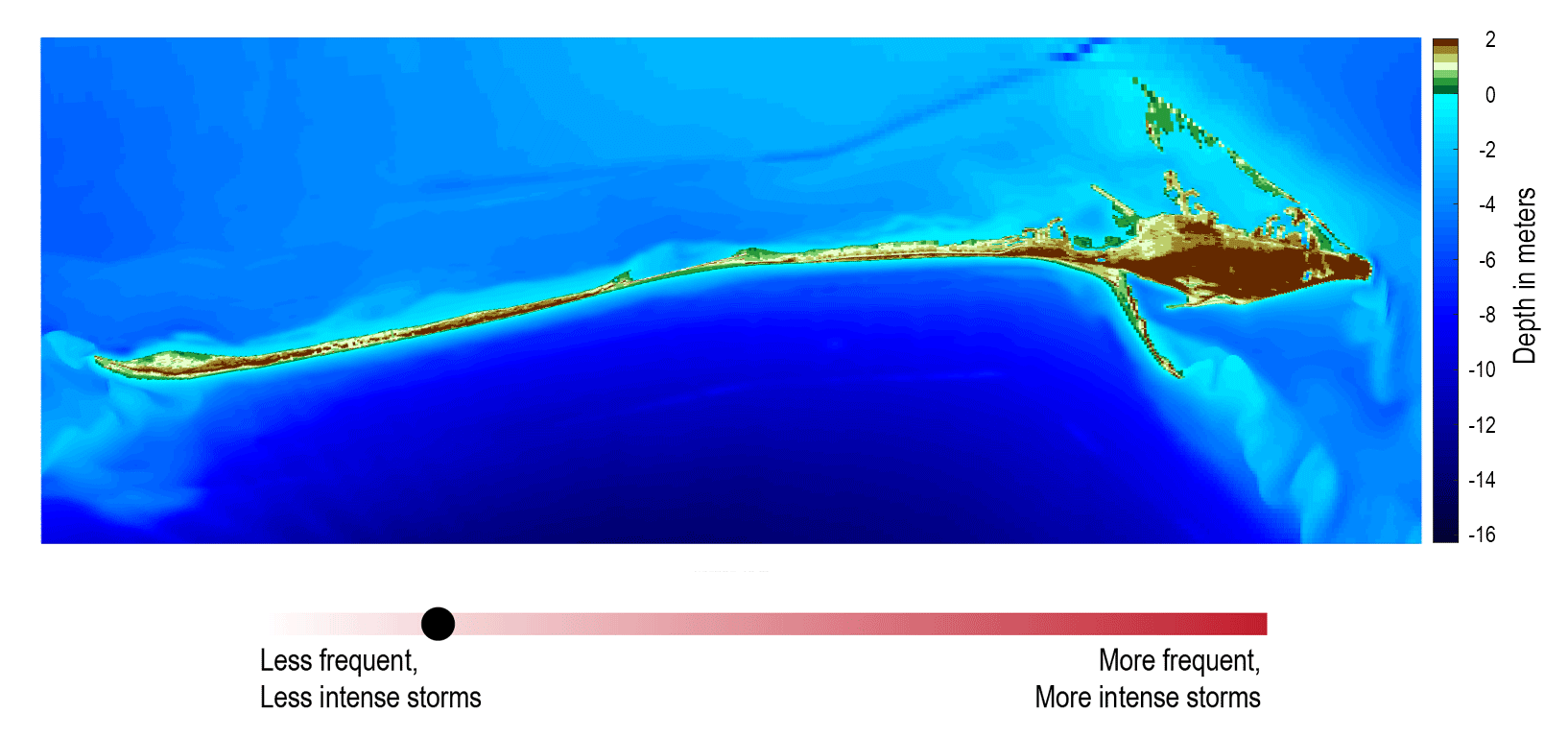
Storm and sea level rise scenario model for Dauphin Island, Alabama
Storm and sea level rise scenario model for Dauphin Island, AlabamaStorm and sea level rise scenario models, like the one shown here, can be used to explore the future. This model shows what Dauphin Island may look like 10 years from now if storms become stronger and more frequent (Passeri and others, 2018).

Nantucket and Marthas Vineyard geologic illustrations
Nantucket and Marthas Vineyard geologic illustrationsGeologic sections (C-C', D-D', and E-E') illustrating the general distributions and thicknesses of seismic stratigraphic units and major unconformities in the Martha’s Vineyard and Nantucket study areas.

Coastal wetland ecosystems in Jamaica Bay, New York,
Coastal wetland ecosystems in Jamaica Bay, New York,Coastal wetland ecosystems in Jamaica Bay, New York, provide important ecosystem services along the highly urbanized Atlantic coast.
Coastal wetland ecosystems in Jamaica Bay, New York,
Coastal wetland ecosystems in Jamaica Bay, New York,Coastal wetland ecosystems in Jamaica Bay, New York, provide important ecosystem services along the highly urbanized Atlantic coast.

A brain coral infected with Stony Coral Tissue Loss Disease
A brain coral infected with Stony Coral Tissue Loss DiseaseA brain coral infected with Stony Coral Tissue Loss Disease (SCTLD) in the Florida Keys National Marine Sanctuary in April 2018.
A brain coral infected with Stony Coral Tissue Loss Disease
A brain coral infected with Stony Coral Tissue Loss DiseaseA brain coral infected with Stony Coral Tissue Loss Disease (SCTLD) in the Florida Keys National Marine Sanctuary in April 2018.

Faults and features of the Big Sur area
Shaded-relief map of central California showing location of the Big Sur area (white dashed line). Red line shows the San Gregorio-Hosgri fault (SGHF) and the Big Sur Bend between Point Sur (PS) and Piedras Blancas (PB). Black lines show other faults.
Shaded-relief map of central California showing location of the Big Sur area (white dashed line). Red line shows the San Gregorio-Hosgri fault (SGHF) and the Big Sur Bend between Point Sur (PS) and Piedras Blancas (PB). Black lines show other faults.

Big Sur Bend
Perspective view of part of the Big Sur Bend in the San Gregorio-Hosgri fault. The steep slope beside the fault results from uplift along the fault, which is part of the strike-slip fault system that forms the boundary in California between the Pacific and North American tectonic plates.
Perspective view of part of the Big Sur Bend in the San Gregorio-Hosgri fault. The steep slope beside the fault results from uplift along the fault, which is part of the strike-slip fault system that forms the boundary in California between the Pacific and North American tectonic plates.

Illustration describes a barrier island from ocean to lagoon
Illustration describes a barrier island from ocean to lagoonIllustration shows the cross-section of a barrier island progressing from ocean (on the right) to marsh and then lagoon (on the left).
Illustration describes a barrier island from ocean to lagoon
Illustration describes a barrier island from ocean to lagoonIllustration shows the cross-section of a barrier island progressing from ocean (on the right) to marsh and then lagoon (on the left).

Contractor Babak Tehranirad works on an operational model
Contractor Babak Tehranirad works on an operational modelContractor Babak Tehranirad works on an operational model for forecasting flooding around San Francisco Bay.
Contractor Babak Tehranirad works on an operational model
Contractor Babak Tehranirad works on an operational modelContractor Babak Tehranirad works on an operational model for forecasting flooding around San Francisco Bay.

Scientists collect beach elevation data near Moss Landing, California
Scientists collect beach elevation data near Moss Landing, CaliforniaLeft to right: USGS scientist Josh Logan, USGS contractor Babak Tehranirad, and USGS contractor Rae Taylor-Burns (University of California-Santa Cruz graduate student) collect beach elevation data near Moss Landing, California, with precision GPS units carried in their backpacks.
Babak Tehranirad holds a lobster that he caught while on vacation
Babak Tehranirad holds a lobster that he caught while on vacationBabak Tehranirad holds a lobster that he caught while on vacation in March 2017.
Babak Tehranirad holds a lobster that he caught while on vacation
Babak Tehranirad holds a lobster that he caught while on vacationBabak Tehranirad holds a lobster that he caught while on vacation in March 2017.

RV Petrel towing subbottom profiler
RV Petrel towing subbottom profiler (yellow raft) parallel to the beach to measure the thickness of sand offshore.
RV Petrel towing subbottom profiler (yellow raft) parallel to the beach to measure the thickness of sand offshore.

Ocean Bottom Seismometer Recovery
A WHCMSC and WHOI team recovered six intermediate period ocean bottom seismographs from the continental slope offshore New England in Georges Bank. The instruments had been deployed for about ten months to record background, ambient seismic noise.
A WHCMSC and WHOI team recovered six intermediate period ocean bottom seismographs from the continental slope offshore New England in Georges Bank. The instruments had been deployed for about ten months to record background, ambient seismic noise.

Sulfide minerals
Examples of sulfide minerals that occur at hydrothermal vents and are being studied by Amy Gartman: (left to right) sphalerite, an ore of zinc that often contains iron ([Zn,Fe]S); cubes of pyrite, rich in iron (FeS2); and covellite, containing copper and sulfur (CuS).The pyrite cubes are a little more than half an inch on a side.
Examples of sulfide minerals that occur at hydrothermal vents and are being studied by Amy Gartman: (left to right) sphalerite, an ore of zinc that often contains iron ([Zn,Fe]S); cubes of pyrite, rich in iron (FeS2); and covellite, containing copper and sulfur (CuS).The pyrite cubes are a little more than half an inch on a side.

SEABOSS Collage
SEABed Observation and Sampling System (SEABOSS) (center image) and the MiniSEABOSS (right) designed for rapid, inexpensive, and effective collection of seabed imagery (photographs and video) as well sediment samples from the coastal/inner-continental shelf regions.
SEABed Observation and Sampling System (SEABOSS) (center image) and the MiniSEABOSS (right) designed for rapid, inexpensive, and effective collection of seabed imagery (photographs and video) as well sediment samples from the coastal/inner-continental shelf regions.

UAS pilots at Kilauea
Department of Interior UAS pilots from left to right – Elizabeth Pendleton (USGS, Woods Hole, MA), Colin Milone (Office of Aviation Services, AK), John Vogel (USGS; Flagstaff, AZ), Sandy Brosnahan (USGS, Woods Hole, MA), Brandon Forbes (USGS; Tucson, AZ), Chris Holmquist-Johnson (USGS; Fort Collins, CO),&nb
Department of Interior UAS pilots from left to right – Elizabeth Pendleton (USGS, Woods Hole, MA), Colin Milone (Office of Aviation Services, AK), John Vogel (USGS; Flagstaff, AZ), Sandy Brosnahan (USGS, Woods Hole, MA), Brandon Forbes (USGS; Tucson, AZ), Chris Holmquist-Johnson (USGS; Fort Collins, CO),&nb

Sediment textures distribution from Nantucket and Marthas Vineyard, MA
Sediment textures distribution from Nantucket and Marthas Vineyard, MAThe distribution of sediment textures within the study area. The bottom-type classification is from Barnhardt and others (1998) and is based on 16 sediment classes. The classification is based on four sediment units that include gravel (G), mud (M), rock (R), and sand (S). If the texture is greater than 90 percent, it is labeled with a single letter.

Scientist surveying the behavior of birds at Pelican Island, Alabama
Scientist surveying the behavior of birds at Pelican Island, AlabamaScientist surveying the presence and behavior of birds at Pelican Island, Alabama. The CMHRP is working with personnel within the Ecosystems Mission Area on this project to identify how physical characteristics of barrier islands influence use by wintering shorebirds.
Releasing a loggerhead with radio tag
A loggerhead sea turtle, outfitted with a popoff ADL package (orange item on the turtle’s back), is released by New England Aquarium Biologist Nick Whitney.
A loggerhead sea turtle, outfitted with a popoff ADL package (orange item on the turtle’s back), is released by New England Aquarium Biologist Nick Whitney.
Deployment of the chirp seismic instrument from the beach
Deployment of the chirp seismic instrument from the beachMost underwater seismic data is collected from large research vessels; however, the shoreface environment is shallower than areas in which most seismic surveys occur. To get the information we need to assess changes in shoreface geology, we mount our seismic instruments on pontoon floats and deploy the instrument from the beach.

Seismic instrument on pontoon floats deployed from the beach
Seismic instrument on pontoon floats deployed from the beachWe mount our seismic instrument on pontoon floats with wheels. This setup is deployed from the beach and eventually towed behind our survey vessel.
Seismic instrument on pontoon floats deployed from the beach
Seismic instrument on pontoon floats deployed from the beachWe mount our seismic instrument on pontoon floats with wheels. This setup is deployed from the beach and eventually towed behind our survey vessel.