Rainfall intensification amplifies exposure of American Southwest to conditions that trigger postfire debris flows
Improving Postfire Debris-Flow Hazard Assessments In The Pacific Northwest Through Application Of Debris-Flow Models
2022 Chaos Canyon Landslide in Colorado:
Insights revealed by seismic analysis, field investigations, and remote sensing
Insights revealed by seismic analysis, field investigations, and remote sensing
Landslide Hazards Program
The primary objective of the National Landslide Hazards Program is to reduce long-term losses from landslide hazards by improving our understanding of the causes of ground failure and suggesting mitigation strategies.
Landslide Basics
Landslide Basics

What is a landslide? Where do they happen and what causes them? Learn all about the basics of landslides here.
U.S. and Puerto Rico Landslide Hazard Map
U.S. and Puerto Rico Landslide Hazard Map

New high-resolution map of landslide susceptibility for the entire U.S. and Puerto Rico.
Quick Links
Quick Links
Here is where to find some of our most popular content:
News
New USGS map shows where landslides are most likely to occur in U.S.
New USGS map shows where landslides are most likely to occur in U.S.
Un nuevo mapa del USGS muestra dónde es más probable que ocurran deslizamientos de tierra en el país
Un nuevo mapa del USGS muestra dónde es más probable que ocurran deslizamientos de tierra en el país
Publications
Parsimonious high-resolution landslide susceptibility modeling at continental scales
Landslide susceptibility maps are fundamental tools for risk reduction, but the coarse resolution of current continental-scale models is insufficient for local application. Complex relations between topographic and environmental attributes characterizing landslide susceptibility at local scales are not transferrable across areas without landslide data. Existing maps with multiple susceptibility cl
RegionGrow3D: A deterministic analysis for characterizing discrete three-dimensional landslide source areas on a regional scale
Regional-scale characterization of shallow landslide hazards is important for reducing their destructive impact on society. These hazards are commonly characterized by (a) their location and likelihood using susceptibility maps, (b) landslide size and frequency using geomorphic scaling laws, and (c) the magnitude of disturbance required to cause landslides using initiation thresholds. Typically, t
Postfire sediment mobilization and its downstream implications across California, 1984 – 2021
Fire facilitates erosion through changes in vegetation and soil, with major postfire erosion commonly occurring even with moderate rainfall. As climate warms, the western United States (U.S.) is experiencing an intensifying fire regime and increasing frequency of extreme rain. We evaluated whether these hydroclimatic changes are evident in patterns of postfire erosion by modeling hillslope erosion
Science

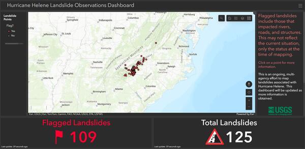
2024 Hurricane Helene Landslide Hazards
Hurricane Helene produced widespread and damaging landslides. The USGS is mapping landslides to support our partners. This page provides information about the extent and severity of landslide impacts. Hurricane Helene made landfall in Florida as a Category 4 storm on Thursday, September 26th, 2024. The hurricane continued across the southern Appalachian Mountains producing record rainfall. This...

2024 Pedersen Lagoon Landslide-Generated Tsunami
A landslide produced a tsunami in Pedersen Lagoon, southwest of Seward, Alaska on Wednesday, August 7th, 2024, at approximately 04:55 AKDT / 12:55 UTC. Preliminary surveying indicates that the landslide generated a tsunami of 17 meters high (approx. 56 ft) or more in Upper Pedersen Lagoon, reducing to about one meter high (approx. 3 feet) in Lower Pedersen Lagoon. Runup heights reported here are...

Landslide Basics
Landslides occur in all 50 states and territories and they affect lives, property, infrastructure, and the environment. Understanding when, where, and how landslides occur can help to reduce the risk of living with these natural hazards.