



Debris flow deposit at the outlet of the Tumalt Creek drainage basin, Columbia River Gorge, Oregon, following storms in January 2021.
Postfire debris-flow hazard assessments
Multi-site evaluation of a postfire debris-flow runout forecast method
2024 Elk Fire
Bighorn National Forest, Wyoming
Bighorn National Forest, Wyoming
2021 Muckamuck Fire burn area
Okanogan County, Washington
Okanogan County, Washington
2020 Cameron Peak Fire burn area
Roosevelt National Forest, Colorado
Roosevelt National Forest, Colorado
2020 Dolan Fire
Los Padres National Forest, California
Los Padres National Forest, California
Wildfires can dramatically alter how water moves across the landscape. After a fire, vegetation is removed and soil properties change, reducing the ground’s ability to absorb rainfall. As a result, even modest rainstorms can trigger dangerous flash floods and debris flows in steep burned areas.
Postfire debris flows are fast-moving mixtures of water, mud, rocks, and vegetation that can surge downslope like flowing concrete. These flows often move faster than a person can run and may travel far beyond the burned area, posing risks to people, homes, roads, and infrastructure. They are typically triggered by short bursts of intense rainfall and can occur during the first storm following a wildfire.
This project develops rapid methods to evaluate postfire debris-flow hazards and advances research on the processes that control their initiation and growth. The goal is to provide reliable scientific information that helps federal, state, and local agencies reduce risks and improve preparedness in recently burned landscapes.
USGS Postfire Debris-Flow Hazard Assessments
Media
Sources/Usage: Public Domain. View Media Details
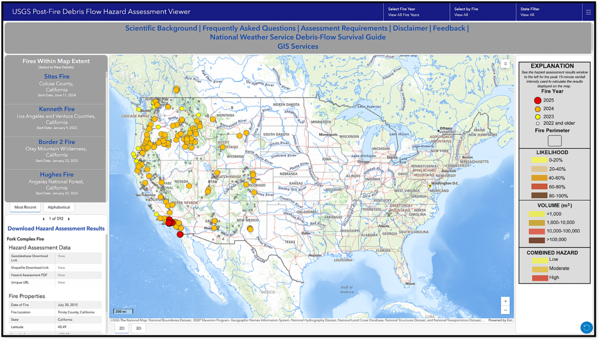
The USGS conducts postfire debris-flow hazard assessments for select fires in the western United States, assessing hundreds of thousands of acres of steep, burned terrain each year. These assessments use information about watershed characteristics, rainfall, and soil properties to answer a few key questions:
- Which burned watersheds are most susceptible to debris flows?
- What types of rainstorms could trigger debris flows?
- How much mud, rock and other debris are these flows capable of carrying?
- How far might debris flows travel?
Assessment results help watershed emergency response teams and other partners understand where debris flows could threaten downstream communities, roads, and infrastructure.
Use the links below to explore hazard maps, assessment data, and the software behind USGS postfire debris-flow assessments.
Hazard Maps
Hazard Maps
Access hazard assessment data
Access hazard assessment data
Software
Software
Request a hazard assessment
Partners typically provide the data needed to conduct an assessment, but anyone may request an assessment for a relevant burned area.
Learn what data inputs are required for conducting a hazard assessment.
Postfire Debris-flow Science
In addition to emergency hazard assessments, the USGS postfire debris-flow project collects data and conducts research to better understand debris-flow processes. This work supports the science behind current hazard models and helps guide future model improvements.
Project research also addresses key questions, including how long burned areas remain susceptible to debris flows and how far debris flows may travel beyond the burned area. Data and publications related to postfire debris flows are available using the tabs at the top of the page.
Use the monitoring, recovery, and runout links below to learn where we collect data and how ongoing research is improving our understanding of how burned areas recover and debris-flow runout mapping.
Media

Sources/Usage: Public Domain. View Media Details
A postfire debris flow in the area burned by the 2016 Fish Fire, Los Angeles county, California. The flow was triggered by heavy rainfall on January 20, 2017.
Learn More
-
Postfire Recovery
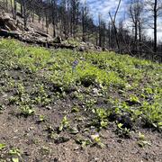
“How long, after wildfire do I need to be concerned about debris flows in my area?” The USGS conducts research to evaluate the recovery of burned areas using field monitoring stations, satellite-based data, and numerical models. This work facilitates the development of USGS hazard assessment products that are geared to answer this question.
-

Postfire Debris-flow Runout
"How far will debris flows travel?" Understanding how far debris flows can travel and what the impacts may be is one of the most important questions we face to effectively protect life and property from debris-flow hazards.
-

Postfire Monitoring and Data Collection
The USGS collects data after wildfires and following storm events to better understand debris-flow hazards and their impacts.
Below is a list of science sites associated with this project.

Scientific Background
The scientific background information for Emergency Assessment of Postfire Debris-Flow Hazards.
Postfire Debris Flow Science Infographic
Postfire Debris Flow Science Infographic

Post-wildfire debris flow: 2016 Fish Fire, Las Lomas Canyon
The June 2016 Fish Fire burned over 12 km^2 in Los Angeles County, California. After the fire, the USGS installed an automated rain-triggered camera to monitor post-wildfire flooding and debris flow in a small canyon above the Las Lomas debris basin in Duarte. This video shows the peak flow triggered by an intense rainstorm on January 20, 2017.
Filter Total Items: 31

Tumalt Creek Debris Flow
Debris flow deposit at the outlet of the Tumalt Creek drainage basin, Columbia River Gorge, Oregon, following storms in January 2021.

Home damaged by post-wildfire debris flow in Montecito, CA.
Home damaged by post-wildfire debris flow in Montecito, CA.Damage from a major post-wildfire landslide that occurred on 9 January 2018 near Montecito, Santa Barbara County as a result of the 2017 Thomas Fire.
Home damaged by post-wildfire debris flow in Montecito, CA.
Home damaged by post-wildfire debris flow in Montecito, CA.Damage from a major post-wildfire landslide that occurred on 9 January 2018 near Montecito, Santa Barbara County as a result of the 2017 Thomas Fire.

Debris flow after the 2003 Old Gran Prix fire
Damage from a major post-wildfire landslide that occurred on 25 December 2003 near Devore, San Bernardino County as a result of the Old/Grand Prix fires that ran through the San Bernardino Mountains.
Damage from a major post-wildfire landslide that occurred on 25 December 2003 near Devore, San Bernardino County as a result of the Old/Grand Prix fires that ran through the San Bernardino Mountains.
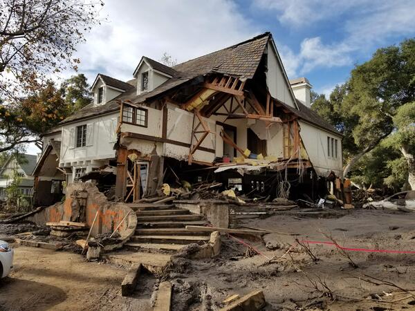
Montecito home damaged by post-wildfire debrisflow.
Montecito home damaged by post-wildfire debrisflow.Damage from a major post-wildfire landslide that occurred on 9 January 2018 near Montecito, Santa Barbara County as a result of the 2017 Thomas Fire.
Montecito home damaged by post-wildfire debrisflow.
Montecito home damaged by post-wildfire debrisflow.Damage from a major post-wildfire landslide that occurred on 9 January 2018 near Montecito, Santa Barbara County as a result of the 2017 Thomas Fire.

Montecito after debris flow
The Dec. 4, 2017 Thomas fire, Southern California's largest wildfire on record, burned more than 280,000 acres across Ventura and Santa Barbara counties for nearly a month.
The Dec. 4, 2017 Thomas fire, Southern California's largest wildfire on record, burned more than 280,000 acres across Ventura and Santa Barbara counties for nearly a month.

Geologists assess scene after debris flow
Geologists assess boulders displaced during the Montecito debris flow event on Jan. 9, 2018.
Geologists assess boulders displaced during the Montecito debris flow event on Jan. 9, 2018.

Geologists assess damage after debris-flow event
USGS geologists deployed to Santa Barbara County to support a geohazard assessment of the Montecito area
USGS geologists deployed to Santa Barbara County to support a geohazard assessment of the Montecito area

Post-wildfire Flood and Debris Flow: 2014 Silverado Fire
Post-wildfire Flood and Debris Flow: 2014 Silverado FireIn 2014, the Silverado Fire burned approximately 4 km^2 in Orange County, California. After the fire, the USGS installed an automated rain-triggered camera to monitor post-wildfire flooding and debris flow at the outlet of a small 0.6 km^2 basin within the burn area.
Post-wildfire Flood and Debris Flow: 2014 Silverado Fire
Post-wildfire Flood and Debris Flow: 2014 Silverado FireIn 2014, the Silverado Fire burned approximately 4 km^2 in Orange County, California. After the fire, the USGS installed an automated rain-triggered camera to monitor post-wildfire flooding and debris flow at the outlet of a small 0.6 km^2 basin within the burn area.

Debris Flow Damage
House engulfed by debris flows generated in response to a rainstorm on February 6, 2010. This house was west of Briar Wood Canyon in southern California. The small, but steep and rugged drainage basin above this home was burned the previous summer by the Station Fire, the largest fire in the history of Los Angeles County.
House engulfed by debris flows generated in response to a rainstorm on February 6, 2010. This house was west of Briar Wood Canyon in southern California. The small, but steep and rugged drainage basin above this home was burned the previous summer by the Station Fire, the largest fire in the history of Los Angeles County.

Post-fire Debris Flow
Debris Flow in Cable Canyon following the 2003 Old Fire in the San Bernardino Mountains, California.
Debris Flow in Cable Canyon following the 2003 Old Fire in the San Bernardino Mountains, California.
Wildfires can dramatically alter how water moves across the landscape. After a fire, vegetation is removed and soil properties change, reducing the ground’s ability to absorb rainfall. As a result, even modest rainstorms can trigger dangerous flash floods and debris flows in steep burned areas.
Postfire debris flows are fast-moving mixtures of water, mud, rocks, and vegetation that can surge downslope like flowing concrete. These flows often move faster than a person can run and may travel far beyond the burned area, posing risks to people, homes, roads, and infrastructure. They are typically triggered by short bursts of intense rainfall and can occur during the first storm following a wildfire.
This project develops rapid methods to evaluate postfire debris-flow hazards and advances research on the processes that control their initiation and growth. The goal is to provide reliable scientific information that helps federal, state, and local agencies reduce risks and improve preparedness in recently burned landscapes.
USGS Postfire Debris-Flow Hazard Assessments
Media
Sources/Usage: Public Domain. View Media Details
The USGS conducts postfire debris-flow hazard assessments for select fires in the western United States, assessing hundreds of thousands of acres of steep, burned terrain each year. These assessments use information about watershed characteristics, rainfall, and soil properties to answer a few key questions:
- Which burned watersheds are most susceptible to debris flows?
- What types of rainstorms could trigger debris flows?
- How much mud, rock and other debris are these flows capable of carrying?
- How far might debris flows travel?
Assessment results help watershed emergency response teams and other partners understand where debris flows could threaten downstream communities, roads, and infrastructure.
Use the links below to explore hazard maps, assessment data, and the software behind USGS postfire debris-flow assessments.
Hazard Maps
Hazard Maps
Access hazard assessment data
Access hazard assessment data
Software
Software
Request a hazard assessment
Partners typically provide the data needed to conduct an assessment, but anyone may request an assessment for a relevant burned area.
Learn what data inputs are required for conducting a hazard assessment.
Postfire Debris-flow Science
In addition to emergency hazard assessments, the USGS postfire debris-flow project collects data and conducts research to better understand debris-flow processes. This work supports the science behind current hazard models and helps guide future model improvements.
Project research also addresses key questions, including how long burned areas remain susceptible to debris flows and how far debris flows may travel beyond the burned area. Data and publications related to postfire debris flows are available using the tabs at the top of the page.
Use the monitoring, recovery, and runout links below to learn where we collect data and how ongoing research is improving our understanding of how burned areas recover and debris-flow runout mapping.
Media
Sources/Usage: Public Domain. View Media Details
A postfire debris flow in the area burned by the 2016 Fish Fire, Los Angeles county, California. The flow was triggered by heavy rainfall on January 20, 2017.
Learn More
-
-
Postfire Recovery
“How long, after wildfire do I need to be concerned about debris flows in my area?” The USGS conducts research to evaluate the recovery of burned areas using field monitoring stations, satellite-based data, and numerical models. This work facilitates the development of USGS hazard assessment products that are geared to answer this question.
-
-
Postfire Debris-flow Runout
"How far will debris flows travel?" Understanding how far debris flows can travel and what the impacts may be is one of the most important questions we face to effectively protect life and property from debris-flow hazards.
-
-
Postfire Monitoring and Data Collection
The USGS collects data after wildfires and following storm events to better understand debris-flow hazards and their impacts.
Below is a list of science sites associated with this project.
Scientific Background
The scientific background information for Emergency Assessment of Postfire Debris-Flow Hazards.
Postfire Debris Flow Science Infographic
Postfire Debris Flow Science Infographic
Post-wildfire debris flow: 2016 Fish Fire, Las Lomas Canyon
The June 2016 Fish Fire burned over 12 km^2 in Los Angeles County, California. After the fire, the USGS installed an automated rain-triggered camera to monitor post-wildfire flooding and debris flow in a small canyon above the Las Lomas debris basin in Duarte. This video shows the peak flow triggered by an intense rainstorm on January 20, 2017.
Filter Total Items: 31
Tumalt Creek Debris Flow
Debris flow deposit at the outlet of the Tumalt Creek drainage basin, Columbia River Gorge, Oregon, following storms in January 2021.
Debris flow deposit at the outlet of the Tumalt Creek drainage basin, Columbia River Gorge, Oregon, following storms in January 2021.
Home damaged by post-wildfire debris flow in Montecito, CA.
Home damaged by post-wildfire debris flow in Montecito, CA.Damage from a major post-wildfire landslide that occurred on 9 January 2018 near Montecito, Santa Barbara County as a result of the 2017 Thomas Fire.
Home damaged by post-wildfire debris flow in Montecito, CA.
Home damaged by post-wildfire debris flow in Montecito, CA.Damage from a major post-wildfire landslide that occurred on 9 January 2018 near Montecito, Santa Barbara County as a result of the 2017 Thomas Fire.
Debris flow after the 2003 Old Gran Prix fire
Damage from a major post-wildfire landslide that occurred on 25 December 2003 near Devore, San Bernardino County as a result of the Old/Grand Prix fires that ran through the San Bernardino Mountains.
Damage from a major post-wildfire landslide that occurred on 25 December 2003 near Devore, San Bernardino County as a result of the Old/Grand Prix fires that ran through the San Bernardino Mountains.
Montecito home damaged by post-wildfire debrisflow.
Montecito home damaged by post-wildfire debrisflow.Damage from a major post-wildfire landslide that occurred on 9 January 2018 near Montecito, Santa Barbara County as a result of the 2017 Thomas Fire.
Montecito home damaged by post-wildfire debrisflow.
Montecito home damaged by post-wildfire debrisflow.Damage from a major post-wildfire landslide that occurred on 9 January 2018 near Montecito, Santa Barbara County as a result of the 2017 Thomas Fire.
Montecito after debris flow
The Dec. 4, 2017 Thomas fire, Southern California's largest wildfire on record, burned more than 280,000 acres across Ventura and Santa Barbara counties for nearly a month.
The Dec. 4, 2017 Thomas fire, Southern California's largest wildfire on record, burned more than 280,000 acres across Ventura and Santa Barbara counties for nearly a month.
Geologists assess scene after debris flow
Geologists assess boulders displaced during the Montecito debris flow event on Jan. 9, 2018.
Geologists assess boulders displaced during the Montecito debris flow event on Jan. 9, 2018.
Geologists assess damage after debris-flow event
USGS geologists deployed to Santa Barbara County to support a geohazard assessment of the Montecito area
USGS geologists deployed to Santa Barbara County to support a geohazard assessment of the Montecito area
Post-wildfire Flood and Debris Flow: 2014 Silverado Fire
Post-wildfire Flood and Debris Flow: 2014 Silverado FireIn 2014, the Silverado Fire burned approximately 4 km^2 in Orange County, California. After the fire, the USGS installed an automated rain-triggered camera to monitor post-wildfire flooding and debris flow at the outlet of a small 0.6 km^2 basin within the burn area.
Post-wildfire Flood and Debris Flow: 2014 Silverado Fire
Post-wildfire Flood and Debris Flow: 2014 Silverado FireIn 2014, the Silverado Fire burned approximately 4 km^2 in Orange County, California. After the fire, the USGS installed an automated rain-triggered camera to monitor post-wildfire flooding and debris flow at the outlet of a small 0.6 km^2 basin within the burn area.
Debris Flow Damage
House engulfed by debris flows generated in response to a rainstorm on February 6, 2010. This house was west of Briar Wood Canyon in southern California. The small, but steep and rugged drainage basin above this home was burned the previous summer by the Station Fire, the largest fire in the history of Los Angeles County.
House engulfed by debris flows generated in response to a rainstorm on February 6, 2010. This house was west of Briar Wood Canyon in southern California. The small, but steep and rugged drainage basin above this home was burned the previous summer by the Station Fire, the largest fire in the history of Los Angeles County.
Post-fire Debris Flow
Debris Flow in Cable Canyon following the 2003 Old Fire in the San Bernardino Mountains, California.
Debris Flow in Cable Canyon following the 2003 Old Fire in the San Bernardino Mountains, California.