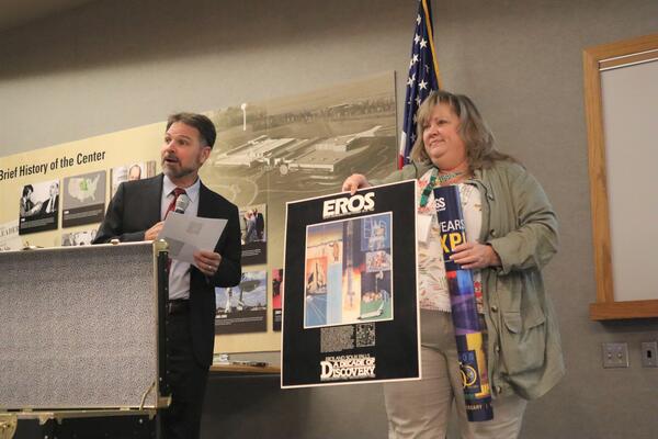
U.S. flag

An official website of the United States government

Images

The National Land Imaging Program supports a variety of geospatial data programs and projects, including the USGS Landsat Program. Browse the images below to see some of the imagery produced using NLI-supported data sources.

Filter Total Items: 497
a satellite image and an image showing the evapotranspiration of the same area in California
Landsat Actual Evapotranspiration of Palo Verde Irrigation District, California

A Landsat 9 natural color image acquired June 29, 2023 (left) and the corresponding Landsat Actual Evapotranspiration (ETa) product (right) display the properties of agricultural fields of Palo Verde Irrigation District, California. 

satellite image of canada
Canada Wildfires
Canada Wildfires
Canada Wildfires

Smoke filled the skies over western Canada and even much of the United States in May 2023. The source was several wildfires in Alberta and British Columbia.

Landsat 9 captured this image on May 6, 2023. 

Smoke filled the skies over western Canada and even much of the United States in May 2023. The source was several wildfires in Alberta and British Columbia.

Landsat 9 captured this image on May 6, 2023. 

Landsat 9 Image of Providence and Cape Cod Area

Cape Cod, the hook-shaped peninsula in the state of Massachusetts, is a popular summertime destination and is easily visible in satellite imagery. 

In this Landsat 9 image, the urban sprawl of Providence, Rhode Island is also displayed, along with Block Island south of the mainland, and Martha's Vineyard and Nantucket south of the Cape. 

Portrait of a man in glasses
Charles J. Robinove
Charles J. Robinove
Charles J. Robinove

The EROS, or Earth Resources Observation Satellite, Program was formally established by Secretarial Order in 1967. Under the EROS Program, Chuck became the Associate Program Manager. In this position, Charles J. Robinove participated in international remote sensing workshops, facilitated remote sensing research, and coordinated program development.

The EROS, or Earth Resources Observation Satellite, Program was formally established by Secretarial Order in 1967. Under the EROS Program, Chuck became the Associate Program Manager. In this position, Charles J. Robinove participated in international remote sensing workshops, facilitated remote sensing research, and coordinated program development.

Landsat 9 Sees Ice at the Apostle Islands

The Apostle Islands National Lakeshore encompasses 69,372 acres, of which 27,323 acres are submerged lands in Lake Superior. This unique collection of islands became a designated National Lakeshore on September 26, 1970. There are no roads or vehicle access to any of the 21 islands within the National Lakeshore.

The Apostle Islands National Lakeshore encompasses 69,372 acres, of which 27,323 acres are submerged lands in Lake Superior. This unique collection of islands became a designated National Lakeshore on September 26, 1970. There are no roads or vehicle access to any of the 21 islands within the National Lakeshore.

satellite image of wildfires in Canada
Canada Wildfire
Canada Wildfire
Canada Wildfire

Smoke filled the skies over western Canada and even much of the United States in May 2023. The source was several wildfires in Alberta and British Columbia.

Near the end of May, rain and cooler temperatures finally brought some relief for the out-of-control fires.

Smoke filled the skies over western Canada and even much of the United States in May 2023. The source was several wildfires in Alberta and British Columbia.

Near the end of May, rain and cooler temperatures finally brought some relief for the out-of-control fires.

satellite image of wildfire in Canada
Canada Wildfires
Canada Wildfires
Canada Wildfires

Smoke filled the skies over western Canada and even much of the United States in May 2023. The source was several wildfires in Alberta and British Columbia.

Landsat 8 captured this image on May 26, 2023. 

Smoke filled the skies over western Canada and even much of the United States in May 2023. The source was several wildfires in Alberta and British Columbia.

Landsat 8 captured this image on May 26, 2023. 

Landsat 9 Image of Shiveluch Volcano April 15, 2023
Landsat 9 Image of Shiveluch Volcano

Found along the Pacific Ring of Fire, Russia’s Shiveluch Volcano began erupting on April 11, 2023. Huge ash clouds spewed from the main crater blanketing over 40,000 square miles (108,000 square kilometers).  The tiny village of Klyuchi, about 30 mi (50 km) from the volcano, plunged into darkness.

Found along the Pacific Ring of Fire, Russia’s Shiveluch Volcano began erupting on April 11, 2023. Huge ash clouds spewed from the main crater blanketing over 40,000 square miles (108,000 square kilometers).  The tiny village of Klyuchi, about 30 mi (50 km) from the volcano, plunged into darkness.

Earth Explorer. Bulk Download Web Application.
BDWA Title Card
BDWA Title Card
BDWA Title Card

This is the title card for the "Bulk Download Web Application" video. This is a tool that allows for bulk downloads of scenes and data from EarthExplorer.

This is the title card for the "Bulk Download Web Application" video. This is a tool that allows for bulk downloads of scenes and data from EarthExplorer.

Landsat 9 Image of Washington D.C.

Landsat 9 image showing Washington D.C. on April 9, 2023. The image is shown using the Red, Green and Blue bands (Bands 4,3,2), combining these three bands produces a natural color view of the area. The image was then sharpened using the panchromatic band (Band 8) which has a higher resolution than the other bands (15 meters compared to 30 meters).

Landsat 9 image showing Washington D.C. on April 9, 2023. The image is shown using the Red, Green and Blue bands (Bands 4,3,2), combining these three bands produces a natural color view of the area. The image was then sharpened using the panchromatic band (Band 8) which has a higher resolution than the other bands (15 meters compared to 30 meters).

Color Infrared Landsat 8 image of Lake Tahoe, California/Nevada USA
Landsat 8 Color Infrared Image of Lake Tahoe

This image of Lake Tahoe, California displays the landscape's vegetation properties in shades of red.  This image was created using Bands 5,4, and 3 from data acquired by Landsat 8 on February 13, 2022. 

This image of Lake Tahoe, California displays the landscape's vegetation properties in shades of red.  This image was created using Bands 5,4, and 3 from data acquired by Landsat 8 on February 13, 2022. 

Children play with interactive Landsat satellite imagery floor puzzle of the Navajo Nation.

Children play with 12’x12′ interactive floor puzzle of the Navajo Nation, created from Landsat satellite imagery by Earth observation education partner, AmericaView  during the Nihima Nahasdzáán−The Art of Mother Earth Gallery Event.

Landsat 1 image of Seattle, Tacoma Washington Area 1973

This satellite image of the Seattle, Tacoma Washington area was acquired by the Landsat 1 Multispectral Scanner (MSS) on September 16, 1973. 

Path 50, Row 27

Visit the Landsat Missions Web Site to learn more about the Landsat satellites that have been acquiring data of the Earth since 1972. 

This satellite image of the Seattle, Tacoma Washington area was acquired by the Landsat 1 Multispectral Scanner (MSS) on September 16, 1973. 

Path 50, Row 27

Visit the Landsat Missions Web Site to learn more about the Landsat satellites that have been acquiring data of the Earth since 1972. 

2023 San Joaquin Valley NDVI map
NDVI map of the San Joaquin Valley Region, March 13, 2023
screenshot of Landsat Archive Dashboard
Landsat Dashboard Archive Image

Use the filters on the right and the map tools to narrow down an area of interest with 10,000 products or less. After filtering, select the download icon in the bottom right corner.

Use the filters on the right and the map tools to narrow down an area of interest with 10,000 products or less. After filtering, select the download icon in the bottom right corner.

Was this page helpful?