
The Railroad Valley Playa, located in east central Nevada, measures about 80 miles long and nearly 20 miles wide, and is a vast and wide-open landscape.
Images
The National Land Imaging Program supports a variety of geospatial data programs and projects, including the USGS Landsat Program. Browse the images below to see some of the imagery produced using NLI-supported data sources.
Filter Total Items: 508

Railroad Valley Playa
The Railroad Valley Playa, located in east central Nevada, measures about 80 miles long and nearly 20 miles wide, and is a vast and wide-open landscape.

National Ocean Month - Earth as Art
Each year, June is National Ocean Month!
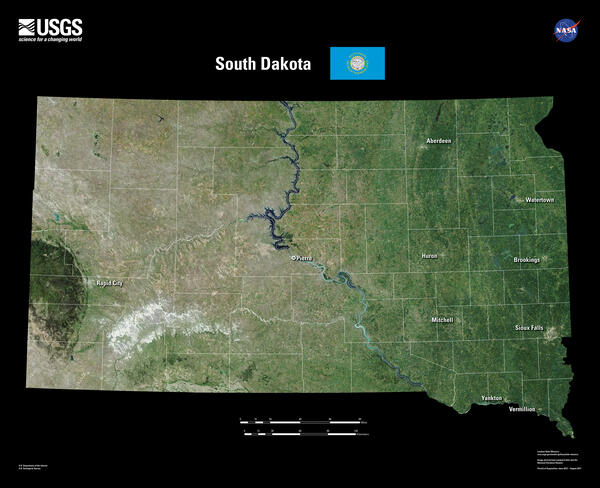
South Dakota Landsat 8 Mosaic
South Dakota is home to the fabled “Black Hills.” Seen from a distance, these pine-covered hills, rising several thousand feet above the surrounding prairie, appear black.
South Dakota is home to the fabled “Black Hills.” Seen from a distance, these pine-covered hills, rising several thousand feet above the surrounding prairie, appear black.

2023 Earth Observation Assessment for agriculture and forestry
2023 Earth Observation Assessment for agriculture and forestryGraphic showing Earth observation inputs found in the 2023 USGEO Earth observation assessment for agriculture and forestry.
2023 Earth Observation Assessment for agriculture and forestry
2023 Earth Observation Assessment for agriculture and forestryGraphic showing Earth observation inputs found in the 2023 USGEO Earth observation assessment for agriculture and forestry.
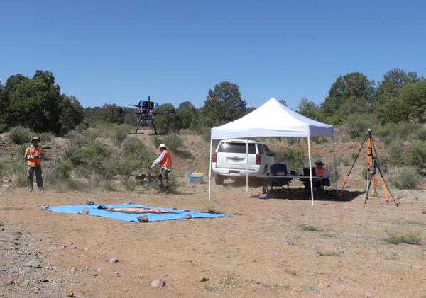
Drone with Gamma Ray Spectrometer
Gamma Ray Spectrometer on drone in New Mexico.
Gamma Ray Spectrometer on drone in New Mexico.

Landsat 8 Image of Ayon Island
Landsat 8's Operational Land Imager (OLI) captured this icy view of Ayon Island on June 17, 2024. The island's low-lying tundra and the shorelines create a picturesque view from its high latitude location in the East Siberian Sea. This unique polar landmass is separated from the mainland by the Malyy Chaunskiy Strait.
Landsat 8's Operational Land Imager (OLI) captured this icy view of Ayon Island on June 17, 2024. The island's low-lying tundra and the shorelines create a picturesque view from its high latitude location in the East Siberian Sea. This unique polar landmass is separated from the mainland by the Malyy Chaunskiy Strait.

Landsat 9 View of Beaufort Sea Melt Ponds
This Landsat 9 image from June 13, 2024, shows the Beaufort Sea near Prudhoe Bay, Alaska, using the Shortwave Infrared, Near Infrared, and Reds (Band 6|5|4), and sharpened with the with Panchromatic band (Band 8). The cyan tones highlight sea ice and melt ponds, while the red areas represent land and vegetation.
This Landsat 9 image from June 13, 2024, shows the Beaufort Sea near Prudhoe Bay, Alaska, using the Shortwave Infrared, Near Infrared, and Reds (Band 6|5|4), and sharpened with the with Panchromatic band (Band 8). The cyan tones highlight sea ice and melt ponds, while the red areas represent land and vegetation.

Norwegian Ambassador visit to USGS EROS
Group photo during the Norwegian Ambassador's visit to EROS.
Group photo during the Norwegian Ambassador's visit to EROS.

USGS and German Aerospace Center sign statement of intent for upcoming Landsat Next mission.
USGS and German Aerospace Center sign statement of intent for upcoming Landsat Next mission.The U.S. Geological Survey and German Aerospace Center (Deutsches Zentrum für Luft-und Raumfahrt or DLR sign statement for plans to continue partnership with the upcoming Landsat Next satellite mission.

Inaugural U.S.-Germany Space Dialogue Space Dialogue
Inaugural U.S.-Germany Space Dialogue Space DialogueImage from the inaugural U.S.-Germany Space Dialogue Space Dialogue in Berlin on June 4, 2024.
Inaugural U.S.-Germany Space Dialogue Space Dialogue
Inaugural U.S.-Germany Space Dialogue Space DialogueImage from the inaugural U.S.-Germany Space Dialogue Space Dialogue in Berlin on June 4, 2024.

USGS and German Aerospace Center sign statement of intent for Landsat Next mission.
USGS and German Aerospace Center sign statement of intent for Landsat Next mission.USGS and German Aerospace Center sign statement of intent for upcoming Landsat Next mission.
(Left to Right): Head of the DLR Space Division Dr. Anke Pagels-Kerp and USGS Deputy Director-Operations Cindy Lodge.

USGS Deputy Director-Operations Cindy Lodge with DLR’s German Remote Sensing Data Center (DFD) Director professor Stefan Dech.
USGS Deputy Director-Operations Cindy Lodge with DLR’s German Remote Sensing Data Center (DFD) Director professor Stefan Dech.USGS Deputy Director-Operations Cindy Lodge shown here with DLR’s German Remote Sensing Data Center (DFD) Director professor Stefan Dech at DLR’s Earth Observation Center in Oberpfaffenhofen finalizing the signatures on the statement of intent for the upcoming Landsat Next mission.

Baotou Sand Test Site
The Baotou Sand Test Site was established to assess the radiometric and spectral performance of high spatial resolution sensor payloads on airborne and satellite platforms. Located at Urad Qianqi, Inner Mongolia in northern China, the site is ∼1270 meters (m) above sea level. The site
The Baotou Sand Test Site was established to assess the radiometric and spectral performance of high spatial resolution sensor payloads on airborne and satellite platforms. Located at Urad Qianqi, Inner Mongolia in northern China, the site is ∼1270 meters (m) above sea level. The site

NUSO remote pilots prepare the hyperspectral sensor for data collection.
NUSO remote pilots prepare the hyperspectral sensor for data collection.NUSO remote pilots Matt Burgess and Victoria Scholl prepare the hyperspectral sensor for data collection.
NUSO remote pilots prepare the hyperspectral sensor for data collection.
NUSO remote pilots prepare the hyperspectral sensor for data collection.NUSO remote pilots Matt Burgess and Victoria Scholl prepare the hyperspectral sensor for data collection.

NUSO remote pilot flies a UAS with hyperspectral payload from a levee on the south bank of the Missouri River.
NUSO remote pilot flies a UAS with hyperspectral payload from a levee on the south bank of the Missouri River.NUSO remote pilot Matt Burgess flies a DJI Matrice 600 Pro UAS with hyperspectral payload from a levee on the south bank of the Missouri River.

Image of the Perry Victory and International Peace Memorial taken from a drone
Image of the Perry Victory and International Peace Memorial taken from a droneImage of the Perry Victory and International Peace Memorial taken from a drone
The NUSO and the National Park Service (NPS) Heritage Document Programs partnered in May 2024 to perform a UAS-based 3D scan of Perry’s Victory and International Peace Memorial.

Landsat 8 image of the Salton Sea 2023
This Landsat 8 image shows the Salton Sea and surrounding area in California.
Landsat 8
Path 39 Row 37
October 18, 2023
Bands 6,5,4
This Landsat 8 image shows the Salton Sea and surrounding area in California.
Landsat 8
Path 39 Row 37
October 18, 2023
Bands 6,5,4

Landsat 8 Image of Tiwi Islands
This Landsat 8 images displays the Tiwi Islands.
The Tiwi Islands are part of the Northern Territory, Australia, north of Darwin in the Timor Sea. They are comprised of the islands of Melville and Bathurst, and nine smaller, uninhabited islands.
This Landsat 8 images displays the Tiwi Islands.
The Tiwi Islands are part of the Northern Territory, Australia, north of Darwin in the Timor Sea. They are comprised of the islands of Melville and Bathurst, and nine smaller, uninhabited islands.

Landsat 9 Image Captures Iceland Volcano Lava
In November 2023 the Svartsengi volcanic system awakened after almost 800 years with a series of earthquakes that opened large cracks in the on Iceland’s Reykjanes Peninsula. An eruption on December 18th spewed lava away from the nearby coastal town of Grindavik, but the January 14, 2024 eruption sent lava directly toward the town.
In November 2023 the Svartsengi volcanic system awakened after almost 800 years with a series of earthquakes that opened large cracks in the on Iceland’s Reykjanes Peninsula. An eruption on December 18th spewed lava away from the nearby coastal town of Grindavik, but the January 14, 2024 eruption sent lava directly toward the town.

NUSO remote pilot setting up the Yellowscan Mapper+ on a UAS for flights at Palo Alto Battlefield National Historic Park.
NUSO remote pilot setting up the Yellowscan Mapper+ on a UAS for flights at Palo Alto Battlefield National Historic Park.Matt Burgess (NUSO) setting up the Yellowscan Mapper+ on a DJI M600 for flights at Palo Alto Battlefield National Historic Park.

Verifying successful lidar data collection while in the field at Palo Alto Battlefield National Historic Park.
Verifying successful lidar data collection while in the field at Palo Alto Battlefield National Historic Park.Verifying successful lidar data collection while in the field at Palo Alto Battlefield National Historic Park.