
Landsat 9 image showing Washington D.C. on April 9, 2023. The image is shown using the Red, Green and Blue bands (Bands 4,3,2), combining these three bands produces a natural color view of the area. The image was then sharpened using the panchromatic band (Band 8) which has a higher resolution than the other bands (15 meters compared to 30 meters).
Images
The National Land Imaging Program supports a variety of geospatial data programs and projects, including the USGS Landsat Program. Browse the images below to see some of the imagery produced using NLI-supported data sources.
Filter Total Items: 508

Landsat 9 Image of Washington D.C.
Landsat 9 image showing Washington D.C. on April 9, 2023. The image is shown using the Red, Green and Blue bands (Bands 4,3,2), combining these three bands produces a natural color view of the area. The image was then sharpened using the panchromatic band (Band 8) which has a higher resolution than the other bands (15 meters compared to 30 meters).

Landsat 8 Color Infrared Image of Lake Tahoe
This image of Lake Tahoe, California displays the landscape's vegetation properties in shades of red. This image was created using Bands 5,4, and 3 from data acquired by Landsat 8 on February 13, 2022.
This image of Lake Tahoe, California displays the landscape's vegetation properties in shades of red. This image was created using Bands 5,4, and 3 from data acquired by Landsat 8 on February 13, 2022.

Fractional Snow Cover Area of Lake Tahoe
The Landsat Fractional Snow Covered Area (fSCA) product provides per-pixel fractional snow cover maps that indicate the percentage of a pixel covered by snow.
The Landsat Fractional Snow Covered Area (fSCA) product provides per-pixel fractional snow cover maps that indicate the percentage of a pixel covered by snow.

Thumbnail for IOW Brunt Ice Shelf 2023
This is the thumbnail image for an Image of the Week about a 2023 update of the Brunt Ice Shelf event.
This is the thumbnail image for an Image of the Week about a 2023 update of the Brunt Ice Shelf event.

Children play with interactive Landsat satellite imagery floor puzzle of the Navajo Nation.
Children play with interactive Landsat satellite imagery floor puzzle of the Navajo Nation.Children play with 12’x12′ interactive floor puzzle of the Navajo Nation, created from Landsat satellite imagery by Earth observation education partner, AmericaView during the Nihima Nahasdzáán−The Art of Mother Earth Gallery Event.
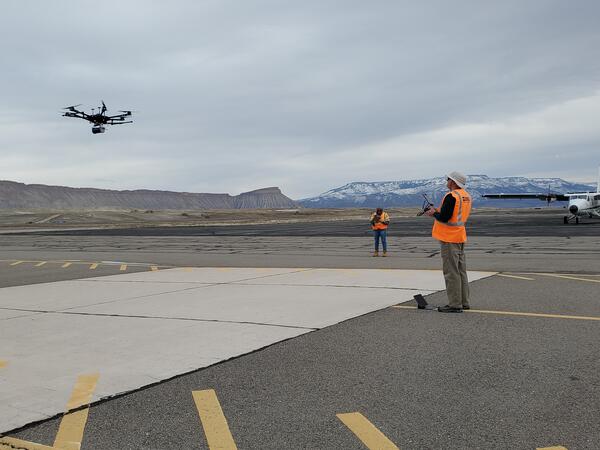
Drone being flown for instrument testing
Gamma Ray Spectrometer testing at DOE Environmental Radiation Calibration Facility located on Grand Junction Airport.
Gamma Ray Spectrometer testing at DOE Environmental Radiation Calibration Facility located on Grand Junction Airport.

Landsat 1 image of Seattle, Tacoma Washington Area 1973
Landsat 1 image of Seattle, Tacoma Washington Area 1973This satellite image of the Seattle, Tacoma Washington area was acquired by the Landsat 1 Multispectral Scanner (MSS) on September 16, 1973.
Path 50, Row 27
Visit the Landsat Missions Web Site to learn more about the Landsat satellites that have been acquiring data of the Earth since 1972.

Earthshots Tournament 2023 Square
32 satellite images are vying for the coveted title of Earthshot. See the images and download your bracket here:
https://geonarrative.usgs.gov/earthshots-tournament/
32 satellite images are vying for the coveted title of Earthshot. See the images and download your bracket here:
https://geonarrative.usgs.gov/earthshots-tournament/

NDVI map of the San Joaquin Valley Region, March 13, 2023
NDVI map of the San Joaquin Valley Region, March 13, 2023A Landsat Surface Reflectance (SR) Normalized Difference Index (NDVI) map of the San Joaquin Valley region of California on March 13, 2023.
NDVI map of the San Joaquin Valley Region, March 13, 2023
NDVI map of the San Joaquin Valley Region, March 13, 2023A Landsat Surface Reflectance (SR) Normalized Difference Index (NDVI) map of the San Joaquin Valley region of California on March 13, 2023.

Landsat Dashboard Archive Image
Use the filters on the right and the map tools to narrow down an area of interest with 10,000 products or less. After filtering, select the download icon in the bottom right corner.
Use the filters on the right and the map tools to narrow down an area of interest with 10,000 products or less. After filtering, select the download icon in the bottom right corner.

Image of the Week (IOW) Cheyenne Bottoms Dries Out thumbnail
Image of the Week (IOW) Cheyenne Bottoms Dries Out thumbnailImage of the Week (IOW) Cheyenne Bottoms Dries Out thumbnail. Image of the Week highlights satellite and other remote sensing imagery from around the world.
Image of the Week (IOW) Cheyenne Bottoms Dries Out thumbnail
Image of the Week (IOW) Cheyenne Bottoms Dries Out thumbnailImage of the Week (IOW) Cheyenne Bottoms Dries Out thumbnail. Image of the Week highlights satellite and other remote sensing imagery from around the world.

Landsat 9 mosaic of Richat Structure
The Richat Structure, also known as the Eye of the Sahara, is a prominent circular geological formation in the Sahara Desert. The formation stretches across a 40 km-wide region in Mauritania in Northwest Africa.
This mosaic of the Richat Structure and surrounding area was creating using four natural color Landsat 9 images (Bands 4,3,2):

Pecora Award 2023 Call for Nominations
Pecora award 2023 flyer announcing call for nominations, due April 15, 2023. This image details the procedure for nominations, eligibility, and privacy statement. Visit this USGS page for eligibility requirements and the nomination process.
Pecora award 2023 flyer announcing call for nominations, due April 15, 2023. This image details the procedure for nominations, eligibility, and privacy statement. Visit this USGS page for eligibility requirements and the nomination process.

RCMAP Factsheet
A New RCMAP Factsheet is available. View it here: https://pubs.er.usgs.gov/publication/fs20233004
A New RCMAP Factsheet is available. View it here: https://pubs.er.usgs.gov/publication/fs20233004

Landsat 8 image of California Central Coast
This Landsat 8 image of a portion of the Central Coast of California (WRS2 Path 43 Row 35) was acquired on January 31, 2023. Bands 6,5,4
This Landsat 8 image of a portion of the Central Coast of California (WRS2 Path 43 Row 35) was acquired on January 31, 2023. Bands 6,5,4

Increases in U.S. Analysis Ready Data Tiles with Collection 2
Increases in U.S. Analysis Ready Data Tiles with Collection 2This graphic shows additional tiles available for Collection 2 U.S. Analysis Ready Data (ARD) when compared to Collection 1 U.S. ARD for the same period (1982-2021).
Increases in U.S. Analysis Ready Data Tiles with Collection 2
Increases in U.S. Analysis Ready Data Tiles with Collection 2This graphic shows additional tiles available for Collection 2 U.S. Analysis Ready Data (ARD) when compared to Collection 1 U.S. ARD for the same period (1982-2021).

Taklimakan Desert Receives Rare Snowfall
Landsat 9 captured a rare snowfall in China’s Taklimakan Desert on January 18, 2023. This image uses the shortwave infrared, near infrared, and red bands (B 6|5|4) to highlight the stark contrast between the desert sand and the snow-covered dunes. The sand appears reddish, while the snow is blue.
Landsat 9 captured a rare snowfall in China’s Taklimakan Desert on January 18, 2023. This image uses the shortwave infrared, near infrared, and red bands (B 6|5|4) to highlight the stark contrast between the desert sand and the snow-covered dunes. The sand appears reddish, while the snow is blue.

Landsat 8 Image of Sacramento Valley on Jan 22, 2023
Landsat 8 Image of Sacramento Valley on Jan 22, 2023This natural color Landsat 8 image of the Sacramento Valley area shows the impacts of the relentless rains that impacted the area during the end of December and into the New Year. Turbid river water, saturated fields, and rising reservoirs can be seen near Stockton and Sacramento.

The Diomede Islands
In the right wintry conditions, an ice bridge forms between the Diomede Islands in the Bering Strait. Theoretically, this is the only place where you can walk from Russia to the United States (and vice versa), however travel between one Diomede to the other is strictly forbidden.
In the right wintry conditions, an ice bridge forms between the Diomede Islands in the Bering Strait. Theoretically, this is the only place where you can walk from Russia to the United States (and vice versa), however travel between one Diomede to the other is strictly forbidden.

Excess Water Flows out of California
Nine consecutive rainstorms have poured on California since December 26, 2022, after three years of intensive drought.
Nine consecutive rainstorms have poured on California since December 26, 2022, after three years of intensive drought.

Landsat Scene Downloads from USGS Inventory since 2008
Landsat Scene Downloads from USGS Inventory since 2008This graphic displays the millions of Landsat Level-1 downloads, from 2008 to December 2022.
View more statistics on the Landsat Project Statistics page.
Landsat Scene Downloads from USGS Inventory since 2008
Landsat Scene Downloads from USGS Inventory since 2008This graphic displays the millions of Landsat Level-1 downloads, from 2008 to December 2022.
View more statistics on the Landsat Project Statistics page.