
Landsat Science Products
Unveiling change through the power of Landsat science
Earth Observation Case Studies
Urban Change, Machine Learning, Agriculture, User Profiles and More!
National Land Imaging Program
Our Nation’s economic security and environmental vitality rely on continuous monitoring of the Earth’s continents, islands, and coastal regions.
The USGS National Land Imaging (NLI) Program makes it possible to record, study, and understand how the surface of the Earth is changing at local, regional, national and global scales.
Image of the Week
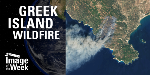
Our latest video features a wildfire on the Greek island of Zakynthos in August 2025, one of many late summer fires in the Ionian Islands.
Landsat Satellites

Over the course of fifty years, eight Landsat satellites have observed the Earth's surface. View each satellite's history and science including first light images, significant events, and unique science for each satellite.
More to Explore
Follow these links to learn more about our remote sensing research partnerships, how to access and download data, and find our image collections, news articles, and more.
News
2026 William T. Pecora Award Nominations Now Being Accepted
Latest in Landsat - February 2026 - Vol. 5 | Issue 2
Using Landsat Data: More Helpful Tutorials Now Available
Publications
Origins, evolutions, and future directions of Landsat science products for advancing global inland water and coastal ocean observations Origins, evolutions, and future directions of Landsat science products for advancing global inland water and coastal ocean observations
ECCOE Landsat Quarterly Calibration and Validation Report—Quarter 2, 2025 ECCOE Landsat Quarterly Calibration and Validation Report—Quarter 2, 2025
ECCOE Landsat quarterly calibration and validation report—Quarter 1, 2025 ECCOE Landsat quarterly calibration and validation report—Quarter 1, 2025
Science

Fire Science
Water and Drought
