
Map of Long Bay, S.C. study area
Images
Images below come from a wide variety of USGS science activities in the Northeast Region. Science Center staff showcase what we do, who we are, and where we work conducting science that inform decision makers and addresses societal needs.
Filter Total Items: 2050

Study area map of Long Bay, S.C.

Study area map of coastal South Carolina
Study area map of coastal South Carolina
Study area map of coastal South Carolina

Stellwagen Bank project research sites in the United States and Canada
Stellwagen Bank project research sites in the United States and CanadaStellwagen Bank project research areas in the United States and Canada
Stellwagen Bank project research sites in the United States and Canada
Stellwagen Bank project research sites in the United States and CanadaStellwagen Bank project research areas in the United States and Canada

Spednic Lake Sunrise
Sunrise on the shore of Spednic Lake before heading out on the lake to collect data for a study.
Sunrise on the shore of Spednic Lake before heading out on the lake to collect data for a study.

Map of Fire Island, N.Y. study area
Map of Fire Island, N.Y. study area
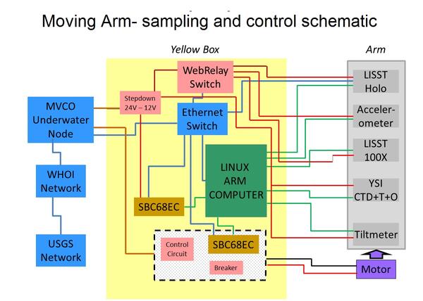
Schematic of system designed to control movement and logging of data
Schematic of system designed to control movement and logging of dataSchematic of system designed to control movement and logging of data collected by the Moving Arm Tripod at Martha's Vineyard Coastal Observatory in 2011.
Schematic of system designed to control movement and logging of data
Schematic of system designed to control movement and logging of dataSchematic of system designed to control movement and logging of data collected by the Moving Arm Tripod at Martha's Vineyard Coastal Observatory in 2011.

Bathymetry of the New England inner shelf and south shore of Martha’s
Bathymetry of the New England inner shelf and south shore of Martha’sBathymetry of the New England inner shelf and south shore of Martha’s Vineyard with model grids
Bathymetry of the New England inner shelf and south shore of Martha’s
Bathymetry of the New England inner shelf and south shore of Martha’sBathymetry of the New England inner shelf and south shore of Martha’s Vineyard with model grids

Outer Banks in South Carolina, November 2011
Picture of the Outer Banks in South Carolina, November 2011
Picture of the Outer Banks in South Carolina, November 2011

Outer Banks in South Carolina, November 2011
Picture of the Outer Banks in South Carolina, November 2011.
Picture of the Outer Banks in South Carolina, November 2011.

Outer Banks in South Carolina, November 2011
The sun begins to set through the trees within the Outer Banks, South Carolina (November 2011).
The sun begins to set through the trees within the Outer Banks, South Carolina (November 2011).

Outer Banks in South Carolina, November 2011
Picture of the Outer Banks in late fall (South Carolina, 2011)
Picture of the Outer Banks in late fall (South Carolina, 2011)

Outer Banks in South Carolina, November 2011
Picture of the Outer Banks in late fall (South Carolina, 2011)
Picture of the Outer Banks in late fall (South Carolina, 2011)

A rainbow over the USGS streamflow station gage house
A rainbow over the USGS streamflow station gage houseA rainbow over the USGS streamflow station gage house at the outlet of Bass Harbor Marsh in Maine (monitoring location 010228955).
A rainbow over the USGS streamflow station gage house
A rainbow over the USGS streamflow station gage houseA rainbow over the USGS streamflow station gage house at the outlet of Bass Harbor Marsh in Maine (monitoring location 010228955).

Rainbow over Bass Harbor Marsh
On October 6, 2011 USGS staff were visiting their streamflow station at the outlet of Bass Harbor Marsh and snapped this photo of a rainbow over the gage house.
On October 6, 2011 USGS staff were visiting their streamflow station at the outlet of Bass Harbor Marsh and snapped this photo of a rainbow over the gage house.

Access to the Harlem River from parks is blocked by infrastructure
Access to the Harlem River from parks is blocked by infrastructureAccess to Harlem River from parks such as Mill Pond, Bronx, NY is blocked by infrastructure like railways or bulkheads along most of its banks
Access to the Harlem River from parks is blocked by infrastructure
Access to the Harlem River from parks is blocked by infrastructureAccess to Harlem River from parks such as Mill Pond, Bronx, NY is blocked by infrastructure like railways or bulkheads along most of its banks

Flood damage from tropical storm Irene
Flood damage from tropical storm Irene, August 28, 2011, washed out Maxam Road bridge on the West Branch North River in Colrain, Massachusetts.
Flood damage from tropical storm Irene, August 28, 2011, washed out Maxam Road bridge on the West Branch North River in Colrain, Massachusetts.

Oceanographic equipment customized to reach the benthic boundary layer
Oceanographic equipment customized to reach the benthic boundary layerSteaming to the deployment site south of Martha's Vineyard, MA in 2011. The platform shown was specially adapted so the arm cycles up and down through the Benthic Boubdary Layer while deployed on the seafloor. For more information see https://soundwaves.usgs.gov/2011/11/fieldwork2.html.

USCGC Healy Coming Back to Free Louis
Nice photo-op of Healy with a striking background.
Nice photo-op of Healy with a striking background.

Arctic Ice Conditions
Ice conditions in the Arctic from CCGS Louis S. St-Laurent.
Ice conditions in the Arctic from CCGS Louis S. St-Laurent.

USCGC Healy Working at Close Quarters with CCGS Louis S. St-Laurent
USCGC Healy Working at Close Quarters with CCGS Louis S. St-LaurentIt is very unusual for large (400 ft) vessels to be so close together during normal science operations. In this case, the skilled ship handling of the Captain from USCGC Healy enabled Healy to back within ~75 ft of Louis to clear ice around the bow of Louis, thereby releasing pressure and allowing her to move again.

Debris line of river peak at USGS station ID 010642505
Debris line of river peak at USGS station ID 010642505A debris line was left on the ground where the river reached its peak at USGS station ID 010642505 Saco River at Bartlett, New Hampshire. This is a type of High-Water Mark that was flagged for an indirect measurement of discharge.