Scientists assess post wildfire debris flow following the 2020 Grizzly Creek fire
Scientists assess post wildfire debris flow following the 2020 Grizzly Creek fireScientists assess post wildfire debris flow following the 2020 Grizzly Creek fire.

Official websites use .gov
A .gov website belongs to an official government organization in the United States.
Secure .gov websites use HTTPS
A lock () or https:// means you’ve safely connected to the .gov website. Share sensitive information only on official, secure websites.
Images described and linked on this webpage come from a wide variety of USGS science activities and presentations performed by USGS Science Center staff members in the Region 7: Upper Colorado Basin. A search tool is provided to narrow the number of image files shown.

Scientists assess post wildfire debris flow following the 2020 Grizzly Creek fire.
Scientists assess post wildfire debris flow following the 2020 Grizzly Creek fire.

Argentine black and white tegus (Salvator merianae) can survive the winter under semi-natural conditions well beyond their current invasive range.
Argentine black and white tegus (Salvator merianae) can survive the winter under semi-natural conditions well beyond their current invasive range.

Debris flow in Glenwood Canyon during the summer of 2021. This event followed the 2020 Grizzly Creek Fire in Glenwood Canyon, Colorado.
Debris flow in Glenwood Canyon during the summer of 2021. This event followed the 2020 Grizzly Creek Fire in Glenwood Canyon, Colorado.

Interstate 70 in Glenwood Canyon, Colorado. In the summer of 2021, travelers in Colorado's Glenwood Canyon were safely evacuated before massive debris flows buried highways and destroyed bridges, thanks to a debris flow warning system developed in part by the U.S. Geological Survey.
Interstate 70 in Glenwood Canyon, Colorado. In the summer of 2021, travelers in Colorado's Glenwood Canyon were safely evacuated before massive debris flows buried highways and destroyed bridges, thanks to a debris flow warning system developed in part by the U.S. Geological Survey.

USGS scientist assesses debris flow in Glenwood Canyon, Colorado. This post-wildfire debris flow follows the 2020 Grizzly Creek Fire.
USGS scientist assesses debris flow in Glenwood Canyon, Colorado. This post-wildfire debris flow follows the 2020 Grizzly Creek Fire.
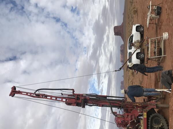
USGS drilling and installing monitoring wells at trench infiltrations site in Monument Valley, Utah, Navajo Nation Reservation, to investigate the feasibility of recharging a groundwater aquifer.
USGS drilling and installing monitoring wells at trench infiltrations site in Monument Valley, Utah, Navajo Nation Reservation, to investigate the feasibility of recharging a groundwater aquifer.

Photo looking downstream from the Pack Creek Road Bridge shows the rain gage on top with a USGS sticker. Below is a solar panel for power. The other white round object contains the data logger and satellite antenna.
Photo looking downstream from the Pack Creek Road Bridge shows the rain gage on top with a USGS sticker. Below is a solar panel for power. The other white round object contains the data logger and satellite antenna.

Rain gauge in Glenwood Canyon, Colorado. After the 2020 Grizzly Creek fire, scientists installed a network of rain gauges and soil moisture sensors throughout the rugged burn area. These instruments provide real-time data on rainfall intensity and duration, which are critical factors in determining the likelihood of a debris flow.
Rain gauge in Glenwood Canyon, Colorado. After the 2020 Grizzly Creek fire, scientists installed a network of rain gauges and soil moisture sensors throughout the rugged burn area. These instruments provide real-time data on rainfall intensity and duration, which are critical factors in determining the likelihood of a debris flow.

Rain gauge installed in Glenwood Canyon, Colorado. After the 2020 Grizzly Creek fire, scientists installed a network of rain gauges and soil moisture sensors throughout the rugged burn area. These instruments provide real-time data on rainfall intensity and duration, which are critical factors in determining the likelihood of a debris flow.
Rain gauge installed in Glenwood Canyon, Colorado. After the 2020 Grizzly Creek fire, scientists installed a network of rain gauges and soil moisture sensors throughout the rugged burn area. These instruments provide real-time data on rainfall intensity and duration, which are critical factors in determining the likelihood of a debris flow.

USGS scientist monitors the burn area following the Grizzly Creek fire of 2020 in Glenwood Canyon, Colorado.
USGS scientist monitors the burn area following the Grizzly Creek fire of 2020 in Glenwood Canyon, Colorado.

Lahontan cutthroat trout (Oncorhynchus clarkii henshawi) is a federally listed threatened species. Ninety-seven percent of their range are small headwater streams in the Great Basin of North America.
Lahontan cutthroat trout (Oncorhynchus clarkii henshawi) is a federally listed threatened species. Ninety-seven percent of their range are small headwater streams in the Great Basin of North America.
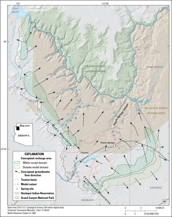
This report includes five chapters. Chapter A (Mason, Knight, and others, 2020) is a summary of this multichapter volume and briefly describes the study area. Chapter B (Mason, Bills, and Macy, 2020) describes the geology and hydrology of the Truxton basin and Hualapai Plateau.
This report includes five chapters. Chapter A (Mason, Knight, and others, 2020) is a summary of this multichapter volume and briefly describes the study area. Chapter B (Mason, Bills, and Macy, 2020) describes the geology and hydrology of the Truxton basin and Hualapai Plateau.

A USGS scientist holds an invasive brown treesnake.
A USGS scientist holds an invasive brown treesnake.

USGS technicians at the USGS Gulf Coast #4 Bonham borehole in preparation for geophysical logging of the Austin Chalk Group and the Eagle Ford Group mudstones, Fannin County, Texas.
USGS technicians at the USGS Gulf Coast #4 Bonham borehole in preparation for geophysical logging of the Austin Chalk Group and the Eagle Ford Group mudstones, Fannin County, Texas.

Bedding features in the core from the USGS Gulf Coast #4 Bonham borehole, in the Eagle Ford Group mudstones from a depth of about 401 feet, Fannin County, Texas. The Eagle Ford Group lies underneath the Austin Chalk and serves as the source rock for much of the Austin Chalk's petroleum.
Bedding features in the core from the USGS Gulf Coast #4 Bonham borehole, in the Eagle Ford Group mudstones from a depth of about 401 feet, Fannin County, Texas. The Eagle Ford Group lies underneath the Austin Chalk and serves as the source rock for much of the Austin Chalk's petroleum.

Looking upstream on the San Miguel River in Colorado in fall 2020 when baseflow (groundwater flowing to streams) is the primary contributor to streamflow.
Looking upstream on the San Miguel River in Colorado in fall 2020 when baseflow (groundwater flowing to streams) is the primary contributor to streamflow.

Researchers instruct volunteers on how to collect dragonfly larvae in Glacier NP as a part of the Dragonfly Mercury Project.
Researchers instruct volunteers on how to collect dragonfly larvae in Glacier NP as a part of the Dragonfly Mercury Project.

3D geologic framework model from west-central New Mexico; graphic shows stratigraphic units in the model being sequentially removed to reveal the deeper units. Faults used in the model appear as vertical “ribbons” as geologic layers are removed.
3D geologic framework model from west-central New Mexico; graphic shows stratigraphic units in the model being sequentially removed to reveal the deeper units. Faults used in the model appear as vertical “ribbons” as geologic layers are removed.

Photograph taken for a USGS project to collect imagery, topographic, and bathymetric data and sources of water and salts of Zuni Salt Lake in west-central New Mexico, 2019.
Photograph taken for a USGS project to collect imagery, topographic, and bathymetric data and sources of water and salts of Zuni Salt Lake in west-central New Mexico, 2019.

Map showing ice cover in the Yellowstone region. Light shaded areas bounded by black and red lines indicate areas covered during the Pinedale (about 20,000-15,000 years ago) and Bull Lake (about 150,000 years ago) glaciations, respectively. Blue lines are contours in thousands of feet on the maximum reconstructed Pinedale glacier surface.
Map showing ice cover in the Yellowstone region. Light shaded areas bounded by black and red lines indicate areas covered during the Pinedale (about 20,000-15,000 years ago) and Bull Lake (about 150,000 years ago) glaciations, respectively. Blue lines are contours in thousands of feet on the maximum reconstructed Pinedale glacier surface.

Rhyolite lavas in the Yellowstone Caldera younger than 631,000 years
Rhyolite lavas in the Yellowstone Caldera younger than 631,000 years