
Map showing distribution of average annualized earthquake loss by region. The high concentration of loss in California and the West Coast is consistent with that region’s high seismic hazard, significant population, and building exposure.
Images
Images described and linked on this webpage come from a wide variety of USGS science activities and presentations performed by USGS Science Center staff members in the Region 7: Upper Colorado Basin. A search tool is provided to narrow the number of image files shown.
Filter Total Items: 551

map1fema366.JPG
Map showing distribution of average annualized earthquake loss by region. The high concentration of loss in California and the West Coast is consistent with that region’s high seismic hazard, significant population, and building exposure.

National Early Detection and Rapid Response Information Systems Contact Information
National Early Detection and Rapid Response Information Systems Contact InformationNational Early Detection and Rapid Response Information Systems Contact Information
National Early Detection and Rapid Response Information Systems Contact Information
National Early Detection and Rapid Response Information Systems Contact InformationNational Early Detection and Rapid Response Information Systems Contact Information

map2fema366.JPG
Although most economic loss is concentrated along the west coast, the distribution of relative earthquake risk, as measured by the Annualized Earthquake Loss Ratio (AELR), is spread throughout the country and it reinforces the fact that earthquakes are a national problem.
Although most economic loss is concentrated along the west coast, the distribution of relative earthquake risk, as measured by the Annualized Earthquake Loss Ratio (AELR), is spread throughout the country and it reinforces the fact that earthquakes are a national problem.

INHABIT Screenshot
This is a screenshot of the INHABIT web-based decision support tool for invasive species habitat visualization and assessment across the contiguous United States
This is a screenshot of the INHABIT web-based decision support tool for invasive species habitat visualization and assessment across the contiguous United States

Hunga Tonga 2.JPG
The large HTHH volcanic explosion created fast low-frequency pressure waves that penetrated about 3.1 miles/5 kilometers into the shallow crust (shown in yellow). Wind and small explosions (shown in blue) create shorter pressure waves that only penetrate down about 328 feet/100 meters.
The large HTHH volcanic explosion created fast low-frequency pressure waves that penetrated about 3.1 miles/5 kilometers into the shallow crust (shown in yellow). Wind and small explosions (shown in blue) create shorter pressure waves that only penetrate down about 328 feet/100 meters.

Hunga Tonga 3.JPG
The waveforms of the ground motion recording and the pressure sensor recording from a station with both types of instruments (see second image above) match up, indicating that the pressure waves are causing the ground (crust) to deflect.
The waveforms of the ground motion recording and the pressure sensor recording from a station with both types of instruments (see second image above) match up, indicating that the pressure waves are causing the ground (crust) to deflect.
Mapping chronic wasting disease management: Identifying opportunities for intervention.
Mapping chronic wasting disease management: Identifying opportunities for intervention.This research effort is an interagency partnership between U.S. Geological Survey and U.S. Fish and Wildlife Service to model the social-ecological system that encompasses chronic wasting disease management in the United States.
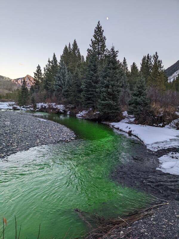
Dye tracer study in the Slate River, Colorado
Sodium fluorescein dye injection into the Slate River used to measure how much groundwater flows into it.
Sodium fluorescein dye injection into the Slate River used to measure how much groundwater flows into it.

Piper Navajo fixed-wing aircraft with rear facing stinger magnetometer
Piper Navajo fixed-wing aircraft with rear facing stinger magnetometerA Piper Navajo fixed-wing aircraft with rear facing stinger magnetometer. Credit: New-Sense Geophysics Limited
Piper Navajo fixed-wing aircraft with rear facing stinger magnetometer
Piper Navajo fixed-wing aircraft with rear facing stinger magnetometerA Piper Navajo fixed-wing aircraft with rear facing stinger magnetometer. Credit: New-Sense Geophysics Limited
Spectral radiometer measurement in Lake Cascade, Idaho
Spectral radiometer measurement in Lake Cascade, IdahoMeasuring water leaving radiance with the spectral radiometer in Lake Cascade, Idaho as part of an effort to validate satellite data over water.
Spectral radiometer measurement in Lake Cascade, Idaho
Spectral radiometer measurement in Lake Cascade, IdahoMeasuring water leaving radiance with the spectral radiometer in Lake Cascade, Idaho as part of an effort to validate satellite data over water.

Helicopter with forward facing stinger magnetometer
Helicopter with forward facing stinger magnetometerAn AS350 helicopter with forward facing stinger magnetometer. Credit: New-Sense Geophysics Limited
Helicopter with forward facing stinger magnetometer
Helicopter with forward facing stinger magnetometerAn AS350 helicopter with forward facing stinger magnetometer. Credit: New-Sense Geophysics Limited

Bear Lake, Colorado
Bear Lake, Colorado is a high alpine lake near tree line that is affected by regional to local fires and vegetation changes.
Bear Lake, Colorado is a high alpine lake near tree line that is affected by regional to local fires and vegetation changes.

Map showing helicopter survey area and near Granby, Colo.
Map showing helicopter survey area and near Granby, Colo.Map showing helicopter survey area and near Granby, Colo. Surveys will not occur directly above populated areas. Black circle indicates study area.
Map showing helicopter survey area and near Granby, Colo.
Map showing helicopter survey area and near Granby, Colo.Map showing helicopter survey area and near Granby, Colo. Surveys will not occur directly above populated areas. Black circle indicates study area.
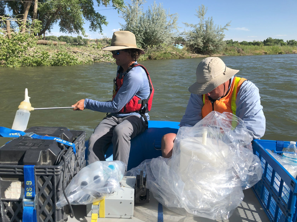
Sampling surface water on the Animas River, New Mexico, 2022
Sampling surface water on the Animas River, New Mexico, 2022USGS researchers collect surface water samples on the Animas River, New Mexico, June 2022
Sampling surface water on the Animas River, New Mexico, 2022
Sampling surface water on the Animas River, New Mexico, 2022USGS researchers collect surface water samples on the Animas River, New Mexico, June 2022

Low-level flight helicopter with stinger
Helicopter conducting low-level flights. Image courtesy Sander Geophysics Ltd.
Helicopter conducting low-level flights. Image courtesy Sander Geophysics Ltd.

Drought Intensity Map, April 19, 2022
Drought Intensity Map compiled by the U.S. Drought Monitor for the area of NOAA's Colorado River Basin River Forecast Center, which includes part of the Great Basin drainage area in western Utah, for April 19, 2024.
Drought Intensity Map compiled by the U.S. Drought Monitor for the area of NOAA's Colorado River Basin River Forecast Center, which includes part of the Great Basin drainage area in western Utah, for April 19, 2024.

USGS Scientist Jill Baron at Loch Vale weather and precipitation sampling station in Rocky Mountain National Park
USGS Scientist Jill Baron at Loch Vale weather and precipitation sampling station in Rocky Mountain National ParkLoch Vale is one of 250 sites in the National Atmospheric Deposition Program/National Trends Network (NADP/NTN). Precipitation samples are collected weekly to present local and national data of pollutants and other chemicals in rain and snow since 1978.

Vehicles drive on Interstate 70 in Glenwood Canyon, Colorado
Vehicles drive on Interstate 70 in Glenwood Canyon, ColoradoVehicles drive on interstate I-70 in Glenwood Canyon, Colorado. In the summer of 2021, travelers in Colorado's Glenwood Canyon were safely evacuated before massive debris flows buried highways and destroyed bridges, thanks to a debris flow warning system developed in part by the U.S. Geological Survey.

Male and female bighorn sheep
Male (ram - left) and female (ewe) bighorn sheep outside of Yellowstone National Park.
Male (ram - left) and female (ewe) bighorn sheep outside of Yellowstone National Park.

Damage from 2021 Glenwood Canyon Debris Flow
The Grizzly Creek Fire initiated in August 2020, and widespread destructive debris flow activity followed the during the summer of 2021. This image shows damage from the summer 2021 debris flow in Glenwood Canyon, Colorado.
The Grizzly Creek Fire initiated in August 2020, and widespread destructive debris flow activity followed the during the summer of 2021. This image shows damage from the summer 2021 debris flow in Glenwood Canyon, Colorado.

Male bighorn sheep
This image shows a male bighorn sheep with large horns.
This image shows a male bighorn sheep with large horns.