
Allison K. Flickinger
Hydrologist, New Mexico Water Science Center
Science and Products
Saturated thickness mapping of the Southern High Plains Aquifer in Eastern New Mexico
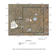
The overall objective of this study is to assist Cannon AFB in understanding and interpreting current and local hydrological conditions by developing an estimate of saturated thickness of the aquifer underlying Cannon AFB and surrounding areas. The Southern High Plains aquifer is the principal source of water for Cannon AFB, the nearby towns of Clovis and Portales, and the local agriculture. The...

Rio Grande Transboundary Integrated Hydrologic Model: Modeling Conjunctive Use to Support Resource Management
The Palomas Basin in New Mexico and the Mesilla Basin in New Mexico and Texas and northern Mexico (study area) compose a geologically and hydrologically complex region (figure 1). This region is characterized by conjunctive use of surface water and groundwater that takes place under a myriad of legal and operational constraints, including the Rio Grande Compact, an international treaty, and the...
Science and Products
Saturated thickness mapping of the Southern High Plains Aquifer in Eastern New Mexico
The overall objective of this study is to assist Cannon AFB in understanding and interpreting current and local hydrological conditions by developing an estimate of saturated thickness of the aquifer underlying Cannon AFB and surrounding areas. The Southern High Plains aquifer is the principal source of water for Cannon AFB, the nearby towns of Clovis and Portales, and the local agriculture. The...
Rio Grande Transboundary Integrated Hydrologic Model: Modeling Conjunctive Use to Support Resource Management
The Palomas Basin in New Mexico and the Mesilla Basin in New Mexico and Texas and northern Mexico (study area) compose a geologically and hydrologically complex region (figure 1). This region is characterized by conjunctive use of surface water and groundwater that takes place under a myriad of legal and operational constraints, including the Rio Grande Compact, an international treaty, and the...