
Watercolor painting of wildlife at Horseshoe Springs, Utah including largemouth bass, common carp, great blue heron, cinnamon teal, spotted sandpiper, black-necked stilt, American avocet, northern harrier.
Benjamin J Siebers
Benjamin Siebers is a hydrologic technician with the Upper Midwest Water Science Center.
Science and Products

Green Lake and its tributaries: Water quality and hydrology
Green Lake is the deepest natural inland lake in Wisconsin. Through time its water quality has degraded, with relatively high phosphorus concentrations and zones of hypoxia. This project is quantifying the water quality of the lake and its tributaries, and it will provide information to help guide efforts to improve the lake.
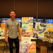
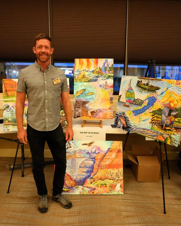
Ben Siebers presents his Art of Science illustration series
Ben Siebers presents his Art of Science illustration series at the Upper Midwest Water Science Center face-to-face meeting.
Filter Total Items: 34
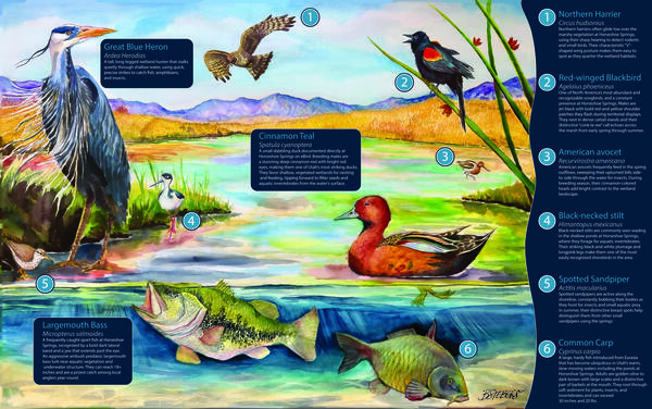
Wildlife of Horseshoe Springs
Watercolor painting of wildlife at Horseshoe Springs, Utah including largemouth bass, common carp, great blue heron, cinnamon teal, spotted sandpiper, black-necked stilt, American avocet, northern harrier.
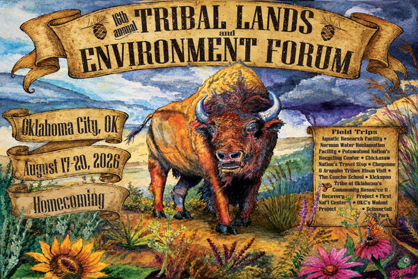
Tribal Lands and Environment Poster
Watercolor painting of a bison on a prairie with culturally significant prairie plant species in the foreground.
Watercolor painting of a bison on a prairie with culturally significant prairie plant species in the foreground.
Tribal Lands and Environment Poster
Watercolor painting of a bison on a prairie with culturally significant prairie plant species in the foreground.
Watercolor painting of a bison on a prairie with culturally significant prairie plant species in the foreground.
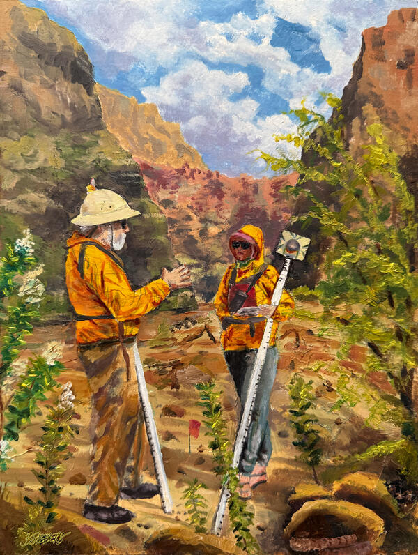
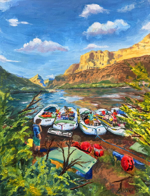
Lessons on the Sandbar
Oil painting of USGS Grand Canyon Monitoring and Research Center (GCMRC) surveying a sandbar monitoring site on the Colorado River in Grand Canyon National Park.
Oil painting of USGS Grand Canyon Monitoring and Research Center (GCMRC) surveying a sandbar monitoring site on the Colorado River in Grand Canyon National Park.
The Home Stretch
Oil painting of USGS monitoring Grand Canyon Monitoring and Research Center (GCMRC) Sandbar Monitoring trip on the Colorado River with Diamond Peak overlooking.
Oil painting of USGS monitoring Grand Canyon Monitoring and Research Center (GCMRC) Sandbar Monitoring trip on the Colorado River with Diamond Peak overlooking.
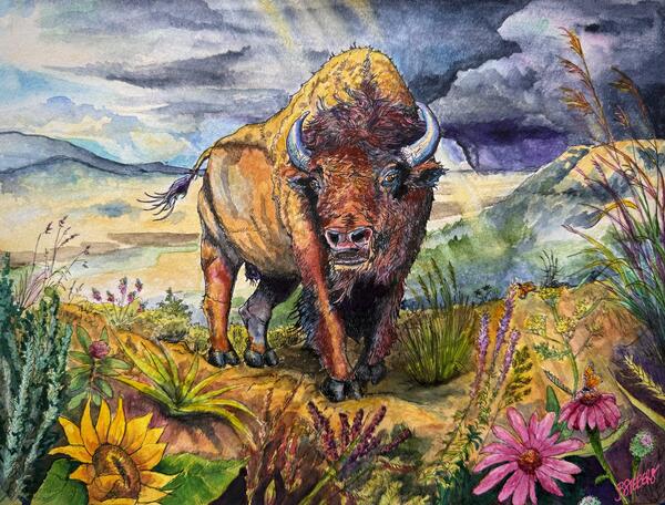
Standing Strong on the Prairie
Watercolor painting of a bison on a prairie with culturally significant prairie plant species in the foreground.
Watercolor painting of a bison on a prairie with culturally significant prairie plant species in the foreground.
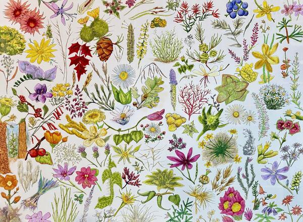
Floral Heritage
Painting (watercolor and ink) depicting the 117 species of plants found in and around a mine site that are utilized by the tribal community in northern Arizona.
Painting (watercolor and ink) depicting the 117 species of plants found in and around a mine site that are utilized by the tribal community in northern Arizona.
Blue Mesa Reservoir in Dry Conditions
Painting (gouache painting) depicting the Blue Mesa Reservoir during a year of low precipitation totals and the resulting cyanobacteria distribution.
Painting (gouache painting) depicting the Blue Mesa Reservoir during a year of low precipitation totals and the resulting cyanobacteria distribution.
Blue Mesa Reservoir in Wet Conditions
Painting (gouache painting) depicting the Blue Mesa Reservoir during a year with relatively greater levels of precipitation and the resulting cyanobacteria distribution.
Painting (gouache painting) depicting the Blue Mesa Reservoir during a year with relatively greater levels of precipitation and the resulting cyanobacteria distribution.

Anniston: Toxic Legacy, Reclaimed future
Anniston: Toxic Legacy, Reclaimed future. – Painting (gouache painting) depicts the PCB contamination embedded in the community and ecosystems of Anniston, Alabama and the restoration work taking place to through U.S. Fish and Wildlife Service, U.S. Geological Survey Natural Resource Damage Assessment and Restoration (NRDAR), and U.S.
Anniston: Toxic Legacy, Reclaimed future. – Painting (gouache painting) depicts the PCB contamination embedded in the community and ecosystems of Anniston, Alabama and the restoration work taking place to through U.S. Fish and Wildlife Service, U.S. Geological Survey Natural Resource Damage Assessment and Restoration (NRDAR), and U.S.
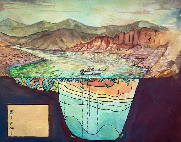
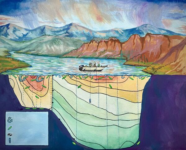
Beneath the Rim: Water Movement Pathways in the Grand Canyon
Beneath the Rim: Water Movement Pathways in the Grand CanyonPainting (gouache painting) is a generalized schematic view, not to scale, through the Grand Canyon with the Colorado River in the center, an unmined breccia pipe on the left side, and the Orphan Mine and associated breccia pipe on the right side. Dashed lines show a conceptual understanding of how water may interact with the Orphan Mine.
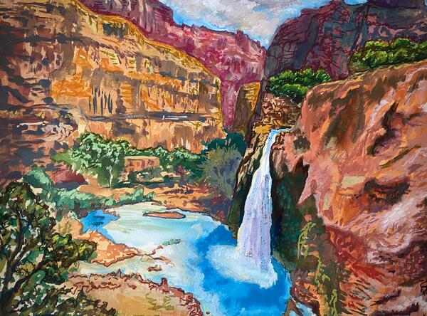
Havasupai Falls Arizona
Top view of Havasupai Falls, its aquamarine colored water is highly recognizable and it is a site of tribal, cultural, and recreational significance to the greater Grand Canyon region.
Top view of Havasupai Falls, its aquamarine colored water is highly recognizable and it is a site of tribal, cultural, and recreational significance to the greater Grand Canyon region.
Ben Siebers presents his Art of Science illustration series
Ben Siebers presents his Art of Science illustration seriesBen Siebers presents his Art of Science illustration series at the Upper Midwest Water Science Center face-to-face meeting.
Ben Siebers presents his Art of Science illustration series
Ben Siebers presents his Art of Science illustration seriesBen Siebers presents his Art of Science illustration series at the Upper Midwest Water Science Center face-to-face meeting.
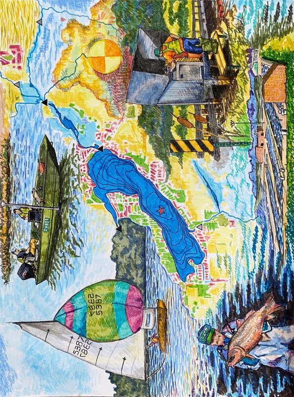
Delavan Lake
Illustration (ink) depicting Delavan Lake and its dynamic water quality response to watershed changes, along with the associated monitoring efforts.
Illustration (ink) depicting Delavan Lake and its dynamic water quality response to watershed changes, along with the associated monitoring efforts.

The Mine Cycle
Mineral production lifecycle from exploration through reclamation.
Artistic rendition of the mineral lifecycle from a natural state through to exploration, permitting, mining, and reclamation. Designed for the Minerals Lifecycle Integrated Science Team to depict one aspect of their science focus.
Mineral production lifecycle from exploration through reclamation.
Artistic rendition of the mineral lifecycle from a natural state through to exploration, permitting, mining, and reclamation. Designed for the Minerals Lifecycle Integrated Science Team to depict one aspect of their science focus.

Where to Go Next
This is a loosely drawn illustration of two hikers on the trail. It was drawn for the final page of a fact sheet and intended for text overlay. The text primarily indicates avenues of further study and next steps of the project.
This is a loosely drawn illustration of two hikers on the trail. It was drawn for the final page of a fact sheet and intended for text overlay. The text primarily indicates avenues of further study and next steps of the project.

Elk
Part of a series of small inset drawings, this is quite simply, an Elk. The backdrop is that of pinyon pine and Red Butte.
Part of a series of small inset drawings, this is quite simply, an Elk. The backdrop is that of pinyon pine and Red Butte.

The Long Haul
This is a small inset drawing of a truck traveling a haul road from a mine site. It is a southwestern landscape, and depicts dust kicked from the road and becoming airborne over the surrounding vegetation and landscape.
This is a small inset drawing of a truck traveling a haul road from a mine site. It is a southwestern landscape, and depicts dust kicked from the road and becoming airborne over the surrounding vegetation and landscape.

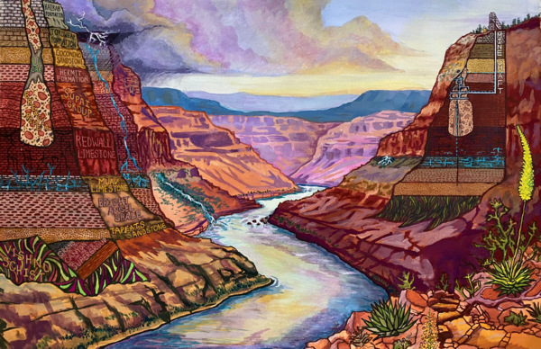
The Big Picture: Grand Canyon and Uranium Mining
Created for a fact sheet on the implications of breccia pipe Uranium mining in the Grand Canyon region, this drawing packs a significant amount of information into a single image.
Created for a fact sheet on the implications of breccia pipe Uranium mining in the Grand Canyon region, this drawing packs a significant amount of information into a single image.

Horn Creek Sign
Part of a series of small inset drawings, this is of a sign located near Horn Creek. The Creek is contaminated with high levels of Uranium. Sign states: "Horn Creek, Danger, Contaminated Water, Do Not Drink! Water in Horn Creek exceeds EPA health standards for radioactivity"
Part of a series of small inset drawings, this is of a sign located near Horn Creek. The Creek is contaminated with high levels of Uranium. Sign states: "Horn Creek, Danger, Contaminated Water, Do Not Drink! Water in Horn Creek exceeds EPA health standards for radioactivity"

Havasupai Falls
Part of a series of small inset drawings, this is a top view of Havasupai Falls, its aquamarine colored water is highly recognizable and it is a site of tribal, cultural, and recreational significance to the greater Grand Canyon region.
Part of a series of small inset drawings, this is a top view of Havasupai Falls, its aquamarine colored water is highly recognizable and it is a site of tribal, cultural, and recreational significance to the greater Grand Canyon region.
Science and Products
Green Lake and its tributaries: Water quality and hydrology
Green Lake is the deepest natural inland lake in Wisconsin. Through time its water quality has degraded, with relatively high phosphorus concentrations and zones of hypoxia. This project is quantifying the water quality of the lake and its tributaries, and it will provide information to help guide efforts to improve the lake.
Ben Siebers presents his Art of Science illustration series
Ben Siebers presents his Art of Science illustration series at the Upper Midwest Water Science Center face-to-face meeting.
Filter Total Items: 34
Wildlife of Horseshoe Springs
Watercolor painting of wildlife at Horseshoe Springs, Utah including largemouth bass, common carp, great blue heron, cinnamon teal, spotted sandpiper, black-necked stilt, American avocet, northern harrier.
Watercolor painting of wildlife at Horseshoe Springs, Utah including largemouth bass, common carp, great blue heron, cinnamon teal, spotted sandpiper, black-necked stilt, American avocet, northern harrier.
Tribal Lands and Environment Poster
Watercolor painting of a bison on a prairie with culturally significant prairie plant species in the foreground.
Watercolor painting of a bison on a prairie with culturally significant prairie plant species in the foreground.
Tribal Lands and Environment Poster
Watercolor painting of a bison on a prairie with culturally significant prairie plant species in the foreground.
Watercolor painting of a bison on a prairie with culturally significant prairie plant species in the foreground.
Lessons on the Sandbar
Oil painting of USGS Grand Canyon Monitoring and Research Center (GCMRC) surveying a sandbar monitoring site on the Colorado River in Grand Canyon National Park.
Oil painting of USGS Grand Canyon Monitoring and Research Center (GCMRC) surveying a sandbar monitoring site on the Colorado River in Grand Canyon National Park.
The Home Stretch
Oil painting of USGS monitoring Grand Canyon Monitoring and Research Center (GCMRC) Sandbar Monitoring trip on the Colorado River with Diamond Peak overlooking.
Oil painting of USGS monitoring Grand Canyon Monitoring and Research Center (GCMRC) Sandbar Monitoring trip on the Colorado River with Diamond Peak overlooking.
Standing Strong on the Prairie
Watercolor painting of a bison on a prairie with culturally significant prairie plant species in the foreground.
Watercolor painting of a bison on a prairie with culturally significant prairie plant species in the foreground.
Floral Heritage
Painting (watercolor and ink) depicting the 117 species of plants found in and around a mine site that are utilized by the tribal community in northern Arizona.
Painting (watercolor and ink) depicting the 117 species of plants found in and around a mine site that are utilized by the tribal community in northern Arizona.
Blue Mesa Reservoir in Dry Conditions
Painting (gouache painting) depicting the Blue Mesa Reservoir during a year of low precipitation totals and the resulting cyanobacteria distribution.
Painting (gouache painting) depicting the Blue Mesa Reservoir during a year of low precipitation totals and the resulting cyanobacteria distribution.
Blue Mesa Reservoir in Wet Conditions
Painting (gouache painting) depicting the Blue Mesa Reservoir during a year with relatively greater levels of precipitation and the resulting cyanobacteria distribution.
Painting (gouache painting) depicting the Blue Mesa Reservoir during a year with relatively greater levels of precipitation and the resulting cyanobacteria distribution.
Anniston: Toxic Legacy, Reclaimed future
Anniston: Toxic Legacy, Reclaimed future. – Painting (gouache painting) depicts the PCB contamination embedded in the community and ecosystems of Anniston, Alabama and the restoration work taking place to through U.S. Fish and Wildlife Service, U.S. Geological Survey Natural Resource Damage Assessment and Restoration (NRDAR), and U.S.
Anniston: Toxic Legacy, Reclaimed future. – Painting (gouache painting) depicts the PCB contamination embedded in the community and ecosystems of Anniston, Alabama and the restoration work taking place to through U.S. Fish and Wildlife Service, U.S. Geological Survey Natural Resource Damage Assessment and Restoration (NRDAR), and U.S.
Beneath the Rim: Water Movement Pathways in the Grand Canyon
Beneath the Rim: Water Movement Pathways in the Grand CanyonPainting (gouache painting) is a generalized schematic view, not to scale, through the Grand Canyon with the Colorado River in the center, an unmined breccia pipe on the left side, and the Orphan Mine and associated breccia pipe on the right side. Dashed lines show a conceptual understanding of how water may interact with the Orphan Mine.
Havasupai Falls Arizona
Top view of Havasupai Falls, its aquamarine colored water is highly recognizable and it is a site of tribal, cultural, and recreational significance to the greater Grand Canyon region.
Top view of Havasupai Falls, its aquamarine colored water is highly recognizable and it is a site of tribal, cultural, and recreational significance to the greater Grand Canyon region.
Ben Siebers presents his Art of Science illustration series
Ben Siebers presents his Art of Science illustration seriesBen Siebers presents his Art of Science illustration series at the Upper Midwest Water Science Center face-to-face meeting.
Ben Siebers presents his Art of Science illustration series
Ben Siebers presents his Art of Science illustration seriesBen Siebers presents his Art of Science illustration series at the Upper Midwest Water Science Center face-to-face meeting.
Delavan Lake
Illustration (ink) depicting Delavan Lake and its dynamic water quality response to watershed changes, along with the associated monitoring efforts.
Illustration (ink) depicting Delavan Lake and its dynamic water quality response to watershed changes, along with the associated monitoring efforts.
The Mine Cycle
Mineral production lifecycle from exploration through reclamation.
Artistic rendition of the mineral lifecycle from a natural state through to exploration, permitting, mining, and reclamation. Designed for the Minerals Lifecycle Integrated Science Team to depict one aspect of their science focus.
Mineral production lifecycle from exploration through reclamation.
Artistic rendition of the mineral lifecycle from a natural state through to exploration, permitting, mining, and reclamation. Designed for the Minerals Lifecycle Integrated Science Team to depict one aspect of their science focus.
Where to Go Next
This is a loosely drawn illustration of two hikers on the trail. It was drawn for the final page of a fact sheet and intended for text overlay. The text primarily indicates avenues of further study and next steps of the project.
This is a loosely drawn illustration of two hikers on the trail. It was drawn for the final page of a fact sheet and intended for text overlay. The text primarily indicates avenues of further study and next steps of the project.
Elk
Part of a series of small inset drawings, this is quite simply, an Elk. The backdrop is that of pinyon pine and Red Butte.
Part of a series of small inset drawings, this is quite simply, an Elk. The backdrop is that of pinyon pine and Red Butte.
The Long Haul
This is a small inset drawing of a truck traveling a haul road from a mine site. It is a southwestern landscape, and depicts dust kicked from the road and becoming airborne over the surrounding vegetation and landscape.
This is a small inset drawing of a truck traveling a haul road from a mine site. It is a southwestern landscape, and depicts dust kicked from the road and becoming airborne over the surrounding vegetation and landscape.
The Big Picture: Grand Canyon and Uranium Mining
Created for a fact sheet on the implications of breccia pipe Uranium mining in the Grand Canyon region, this drawing packs a significant amount of information into a single image.
Created for a fact sheet on the implications of breccia pipe Uranium mining in the Grand Canyon region, this drawing packs a significant amount of information into a single image.
Horn Creek Sign
Part of a series of small inset drawings, this is of a sign located near Horn Creek. The Creek is contaminated with high levels of Uranium. Sign states: "Horn Creek, Danger, Contaminated Water, Do Not Drink! Water in Horn Creek exceeds EPA health standards for radioactivity"
Part of a series of small inset drawings, this is of a sign located near Horn Creek. The Creek is contaminated with high levels of Uranium. Sign states: "Horn Creek, Danger, Contaminated Water, Do Not Drink! Water in Horn Creek exceeds EPA health standards for radioactivity"
Havasupai Falls
Part of a series of small inset drawings, this is a top view of Havasupai Falls, its aquamarine colored water is highly recognizable and it is a site of tribal, cultural, and recreational significance to the greater Grand Canyon region.
Part of a series of small inset drawings, this is a top view of Havasupai Falls, its aquamarine colored water is highly recognizable and it is a site of tribal, cultural, and recreational significance to the greater Grand Canyon region.