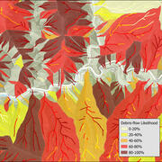
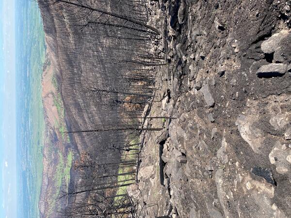
My research focuses on the processes controlling debris-flow initiation and growth, particularly after wildfire, but also in unburned areas.
This research includes a field component that obtains direct measurements of debris flows in natural settings, a modeling component that seeks to explain the observations, and an applied component that focuses on assessment of debris-flow hazards. My previous research at the USGS focused on river mechanics, including bank erosion and the development of model-based approaches to gage streams and rivers.
Education and Certifications
University of Colorado, Ph.D., 2003, Civil Engineering
University of Colorado, M.S., 1998, Civil Engineering
Cornell University, B.S., 1994, Civil Engineering
Science and Products
Calwood Fire "Heil Ranch" Landslide Monitoring Site near Boulder, CO
Wildfire can radically change a mountainous landscape such that even a modest rainstorm is capable of producing deadly and destructive flash flooding and debris flows.
2021 Dixie Fire, Chips Site near Belden, CA
Wildfire can radically change a mountainous landscape such that even a modest rainstorm is capable of producing deadly and destructive flash flooding and debris flows.
2021 Dixie Fire, Chambers Site near Belden, CA
Wildfire can radically change a mountainous landscape such that even a modest rainstorm is capable of producing deadly and destructive flash flooding and debris flows.
Advancing Post-Fire Debris Flow Hazard Science with a Field Deployable Mapping Tool
Mapping the occurrence of post-fire flooding and debris flow is crucial for 1) integrating observations into models used to define rainfall thresholds for early warning, 2) understanding patterns of inundation, and 3) improving models for predictive hazard assessment. Despite the critical role mapping plays in post-fire hazard assessment and early warning, there has not been a standardized approa
How Often Do Rainstorms Cause Debris Flows in Burned Areas of the Southwestern U.S.?
Debris flows, sometimes referred to as mudslides, mudflows, lahars, or debris avalanches, are common types of fast-moving landslides. They usually start on steep hillsides as a result of shallow landslides, or from runoff and erosion that liquefy and accelerate to speeds in excess of 35 mi/h. The consistency of debris flows ranges from thin, watery to thick, rocky mud that can carry large items...
Emergency Assessment of Post-Fire Debris-Flow Hazards
Estimates of the probability and volume of debris flows that may be produced by a storm in a recently burned area, using a model with characteristics related to basin shape, burn severity, soil properties, and rainfall. Wildfire can significantly alter the hydrologic response of a watershed to the extent that even modest rainstorms can produce dangerous flash floods and debris flows. The USGS...
2013 Springs Fire, Ventura County, California
The Springs Fire burned many steep basins in the Santa Monica Mountains east of Oxnard, CA in May, 2013. The USGS has installed a telemetered rain gage to monitor the rainfall conditions in the Springs Fire burn area.
2009 Station Fire, Dunsmore Canyon, Glendale, California
In 2009, the Station Fire burned 160,000 acres in the San Gabriel Mountains. Vegetation has started to return, but it can take many years for a basin to fully recover from the effects of fire.
2009 Station Fire, Arroyo Seco, Pasadena, California
In 2009, the Station Fire burned 160,000 acres in the San Gabriel Mountains. Vegetation has started to return, but it can take many years for a basin to fully recover from the effects of fire.
Reconstruction of an Avalanche: The West Salt Creek Rock Avalanche
Release Date: MAY 25, 2016 The West Salt Creek Rock Avalanche, Colorado, May 25, 2014
Rainfall and Landslides in Southern California
A summary of recent and past landslides and debris flows caused by rainfall in Southern California.
Debris-flow and Flood Video Files, Chalk Cliffs, Colorado, USA, 2019
Chalk Cliffs, located 8 miles southwest of Buena Vista, Colorado, is a natural laboratory for research on runoff-initiated debris flows (Coe et al., 2010). In 2019, there were two monitoring stations operating at Chalk Cliffs. The Upper Station drains an area of 0.06 km2 and was used to monitor flow properties and triggering conditions in the headwaters of the study area. It was equipped with two
Debris-flow and Flood Video Files, Chalk Cliffs, Colorado, USA, 2015
Chalk Cliffs, located 8 miles southwest of Buena Vista, Colorado, is one of the most active debris-flow areas in the state (U.S. Geological Survey). Three stations were set up at Chalk Cliffs which are located sequentially along a channel draining the 0.3 km2 study area. These stations are equipped with rain gauges, laser distance meters, and data loggers to record rainfall and stage data (Kean, e
Debris-flow and Flood Video Files, Chalk Cliffs, Colorado, USA, 2016
Chalk Cliffs located 8 miles southwest of Buena Vista, Colorado, is one of the most active debris-flow areas in the state (U.S. Geological Survey). Three stations were set up at Chalk Cliffs which are located sequentially along a channel draining the 0.3 km2 study area. These stations are equipped with rain gauges, laser distance meters, and data loggers to record rainfall and stage data (Kean, et
Data supporting an analysis of the recurrence interval of post-fire debris-flow generating rainfall in the southwestern United States
This data release supports the analysis of the recurrence interval of post-fire debris-flow generating rainfall in the southwestern United States. We define the recurrence interval of the peak 15-, 30-, and 60-minute rainfall intensities for 316 observations of post-fire debris-flow occurrence in 18 burn areas, 5 U.S. states, and 7 climate types. These data support the analysis described in Staley
Debris-flow monitoring data, Chalk Cliffs, Colorado, USA, 2014
This data release includes 2014 time-series data from three debris-flow monitoring stations at Chalk Cliffs in Chaffee County, Colorado, USA. The data were collected to help identify the triggering conditions, magnitude, and mobility of debris flows at the site. The three stations are located sequentially along a channel draining the 0.3 km^2 study area. The Upper, Middle, and Lower stations have
Monitoring environmental controls on debris-flow sediment supply, Chalk Cliffs, Colorado, 2011 to 2015
This data release includes time-series data of rock temperature, air temperature, wind speed, and humidity at the Chalk Cliffs debris-flow monitoring site in central Colorado (Latitude: 38.73330, Longitude: -106.18704). The data were collected to help identify the environmental controls on rates of rockfall, which is the primary source of debris-flow material at the site. Data were recorded at 1-m
Post-wildfire debris-flow monitoring data, Las Lomas, 2016 Fish Fire, Los Angeles County, California, November 2016 to February 2017
This data release includes time-series data from a monitoring site located in a small (0.12 km2) drainage basin in the Las Lomas watershed in Los Angeles County, CA, USA. The site was established after the 2016 Fish Fire and recorded a series debris flows in the first winter after the fire. The station is located along the channel at the outlet of the study area (34 9'18.50"N, 117 56'
Debris-flow inundation and damage data from the 9 January 2018 Montecito Debris-Flow Event
On 9 January 2018, intense rain above Montecito, California triggered a series of debris flows from steep catchments in the Santa Ynez Mountains. These catchments were burned three weeks earlier by the 1140 km2 Thomas Fire. After exiting the mountain front, the debris flows traveled over 3 km down a series of alluvial fans, killing 23 people and damaging over 400 homes. To understand the flow dyna
Post-wildfire debris-flow monitoring data, Arroyo Seco, 2009 Station Fire, Los Angeles County, California, November 2009 to March 2010.
This data release includes time-series data from a monitoring site located in a small drainage basin in the Arroyo Seco watershed in Los Angeles County, CA, USA (N3788964 E389956, UTM Zone 11, NAD83). The site was established after the 2009 Station Fire and recorded a series debris flows in the first winter after the fire. The data include three types of time-series: (1) 1-minute time series of ra
Map and model input and output data covering N 40.0 40.375 and W 105.25 105.625 in the northern Colorado Front Range for analysis of debris flow initiation resulting from the storm of September 9 13, 2013
Rainfall on 913 September 2013 triggered at least 1,138 debris flows in a 3430 km2 area of the Colorado Front Range. Most flows were triggered in response to two intense rainfall periods, one 12.5-hour-long period on 1112 September, and one 8-hour-long period on 12 September. Data in this project pertain to an area bounded by N 40.0 40.375 and W 105.25 105.625 which includes many of the areas wh
Filter Total Items: 75
Postfire debris flow hazards—Tips to keep you safe
Often referred to as “mudflows,” debris flows are a type of landslide made up of a rapidly moving mixture of dirt, rocks, trees, and water (and sometimes ash) that start on a hillside and travel downvalley. They can easily overflow channels and severely damage houses, vehicles, or other structures. Areas burned by wildfires are especially susceptible to these hazards, which can be triggered by sto
Multi-model comparison of computed debris flow runout for the 9 January 2018 Montecito, California post-wildfire event
Hazard assessment for post-wildfire debris flows, which are common in the steep terrain of the western United States, has focused on the susceptibility of upstream basins to generate debris flows. However, reducing public exposure to this hazard also requires an assessment of hazards in downstream areas that might be inundated during debris flow runout. Debris flow runout models are widely availab
Movement of sediment through a burned landscape: Sediment volume observations and model comparisons in the San Gabriel Mountains, California, USA
Post-wildfire changes to hydrologic and geomorphic systems can lead to widespread sediment redistribution. Understanding how sediment moves through a watershed is crucial for assessing hazards, developing debris flow inundation models, engineering sediment retention solutions, and quantifying the role that disturbances play in landscape evolution. In this study, we used terrestrial and airborne li
Postwildfire soil‐hydraulic recovery and the persistence of debris flow hazards
Deadly and destructive debris flows often follow wildfire, but understanding of changes in the hazard potential with time since fire is poor. We develop a simulation‐based framework to quantify changes in the hydrologic triggering conditions for debris flows as postwildfire infiltration properties evolve through time. Our approach produces time‐varying rainfall intensity‐duration thresholds for ru
U.S. Geological Survey wildland fire science strategic plan, 2021–26
The U.S. Geological Survey (USGS) Wildland Fire Science Strategic Plan defines critical, core fire science capabilities for understanding fire-related and fire-responsive earth system processes and patterns, and informing management decision making. Developed by USGS fire scientists and executive leadership, and informed by conversations with external stakeholders, the Strategic Plan is aligned wi
By
Ecosystems, Natural Hazards, Earth Resources Observation and Science Center, Science Analytics and Synthesis (SAS), Alaska Science Center, Earth Resources Observation and Science (EROS) Center , Forest and Rangeland Ecosystem Science Center, Fort Collins Science Center, Geologic Hazards Science Center, Geology, Geophysics, and Geochemistry Science Center, Western Ecological Research Center (WERC)
Forecasting the frequency and magnitude of postfire debris flows across southern California
Southern California has a long history of damaging debris flows after wildfire. Despite recurrent loss, forecasts of the frequency and magnitude of postfire debris flows are not available for the region like they are for earthquakes. Instead, debris flow hazards are typically assessed in a reactive manner after wildfires. Such assessments are crucial for evaluating debris flow risk by postfire eme
Time since burning and rainfall characteristics impact post-fire debris flow initiation and magnitude
The extreme heat from wildfire alters soil properties and incinerates vegetation, leading to changes in infiltration capacity, ground cover, soil erodibility, and rainfall interception. These changes promote elevated rates of runoff and sediment transport that increase the likelihood of runoff-generated debris flows. Debris flows are most common in the year immediately following wildfire, but temp
Progress and lessons learned from responses to landslide disasters
Landslides have the incredible power to transform landscapes and also, tragically, to cause disastrous societal impacts. Whereas the mechanics and effects of many landslide disasters have been analyzed in detail, the means by which landslide experts respond to these events has garnered much less attention. Herein, we evaluate nine landslide response case histories conducted by the U.S. Geological
Measuring basal force fluctuations of debris flows using seismic recordings and empirical green's functions
We present a novel method for measuring the fluctuating basal normal and shear stresses of debris flows by using along‐channel seismic recordings. Our method couples a simple parameterization of a debris flow as a seismic source with direct measurements of seismic path effects using empirical Green's functions generated with a force hammer. We test this method using two large‐scale (8 and 10 m3) e
The recurrence interval of post-fire debris-flow generating rainfall in the southwestern United States
In the southwestern United States, post-fire debris flows commonly initiate during short bursts of intense rainfall. To date, the frequency of the rainfall rates has not been quantified. Here, we combine an existing database of debris-flow occurrences and corresponding peak storm intensities with a geospatial library of rainfall recurrence interval (RI) information and climate type to determine th
Landslides after wildfire: Initiation, magnitude, and mobility
In the semiarid Southwestern USA, wildfires are commonly followed by runoff-generated debris flows because wildfires remove vegetation and ground cover, which reduces soil infiltration capacity and increases soil erodibility. At a study site in Southern California, we initially observed runoff-generated debris flows in the first year following fire. However, at the same site three years after the
The impact of sediment supply on the initiation and magnitude of runoff-generated debris flows
Rainfall intensity‐duration (ID) thresholds are commonly used to assess the potential for runoff‐generated debris flows, but the sensitivity of these thresholds to sediment supply, which can change rapidly with time, is relatively unexplored. Furthermore, debris flows often self‐organize into distinct surges, but the factors controlling the magnitude and frequency of these surges, including sedime
Science and Products
- Science
Calwood Fire "Heil Ranch" Landslide Monitoring Site near Boulder, CO
Wildfire can radically change a mountainous landscape such that even a modest rainstorm is capable of producing deadly and destructive flash flooding and debris flows.2021 Dixie Fire, Chips Site near Belden, CA
Wildfire can radically change a mountainous landscape such that even a modest rainstorm is capable of producing deadly and destructive flash flooding and debris flows.2021 Dixie Fire, Chambers Site near Belden, CA
Wildfire can radically change a mountainous landscape such that even a modest rainstorm is capable of producing deadly and destructive flash flooding and debris flows.Advancing Post-Fire Debris Flow Hazard Science with a Field Deployable Mapping Tool
Mapping the occurrence of post-fire flooding and debris flow is crucial for 1) integrating observations into models used to define rainfall thresholds for early warning, 2) understanding patterns of inundation, and 3) improving models for predictive hazard assessment. Despite the critical role mapping plays in post-fire hazard assessment and early warning, there has not been a standardized approaHow Often Do Rainstorms Cause Debris Flows in Burned Areas of the Southwestern U.S.?
Debris flows, sometimes referred to as mudslides, mudflows, lahars, or debris avalanches, are common types of fast-moving landslides. They usually start on steep hillsides as a result of shallow landslides, or from runoff and erosion that liquefy and accelerate to speeds in excess of 35 mi/h. The consistency of debris flows ranges from thin, watery to thick, rocky mud that can carry large items...Emergency Assessment of Post-Fire Debris-Flow Hazards
Estimates of the probability and volume of debris flows that may be produced by a storm in a recently burned area, using a model with characteristics related to basin shape, burn severity, soil properties, and rainfall. Wildfire can significantly alter the hydrologic response of a watershed to the extent that even modest rainstorms can produce dangerous flash floods and debris flows. The USGS...2013 Springs Fire, Ventura County, California
The Springs Fire burned many steep basins in the Santa Monica Mountains east of Oxnard, CA in May, 2013. The USGS has installed a telemetered rain gage to monitor the rainfall conditions in the Springs Fire burn area.2009 Station Fire, Dunsmore Canyon, Glendale, California
In 2009, the Station Fire burned 160,000 acres in the San Gabriel Mountains. Vegetation has started to return, but it can take many years for a basin to fully recover from the effects of fire.2009 Station Fire, Arroyo Seco, Pasadena, California
In 2009, the Station Fire burned 160,000 acres in the San Gabriel Mountains. Vegetation has started to return, but it can take many years for a basin to fully recover from the effects of fire.Reconstruction of an Avalanche: The West Salt Creek Rock Avalanche
Release Date: MAY 25, 2016 The West Salt Creek Rock Avalanche, Colorado, May 25, 2014Rainfall and Landslides in Southern California
A summary of recent and past landslides and debris flows caused by rainfall in Southern California. - Data
Debris-flow and Flood Video Files, Chalk Cliffs, Colorado, USA, 2019
Chalk Cliffs, located 8 miles southwest of Buena Vista, Colorado, is a natural laboratory for research on runoff-initiated debris flows (Coe et al., 2010). In 2019, there were two monitoring stations operating at Chalk Cliffs. The Upper Station drains an area of 0.06 km2 and was used to monitor flow properties and triggering conditions in the headwaters of the study area. It was equipped with twoDebris-flow and Flood Video Files, Chalk Cliffs, Colorado, USA, 2015
Chalk Cliffs, located 8 miles southwest of Buena Vista, Colorado, is one of the most active debris-flow areas in the state (U.S. Geological Survey). Three stations were set up at Chalk Cliffs which are located sequentially along a channel draining the 0.3 km2 study area. These stations are equipped with rain gauges, laser distance meters, and data loggers to record rainfall and stage data (Kean, eDebris-flow and Flood Video Files, Chalk Cliffs, Colorado, USA, 2016
Chalk Cliffs located 8 miles southwest of Buena Vista, Colorado, is one of the most active debris-flow areas in the state (U.S. Geological Survey). Three stations were set up at Chalk Cliffs which are located sequentially along a channel draining the 0.3 km2 study area. These stations are equipped with rain gauges, laser distance meters, and data loggers to record rainfall and stage data (Kean, etData supporting an analysis of the recurrence interval of post-fire debris-flow generating rainfall in the southwestern United States
This data release supports the analysis of the recurrence interval of post-fire debris-flow generating rainfall in the southwestern United States. We define the recurrence interval of the peak 15-, 30-, and 60-minute rainfall intensities for 316 observations of post-fire debris-flow occurrence in 18 burn areas, 5 U.S. states, and 7 climate types. These data support the analysis described in StaleyDebris-flow monitoring data, Chalk Cliffs, Colorado, USA, 2014
This data release includes 2014 time-series data from three debris-flow monitoring stations at Chalk Cliffs in Chaffee County, Colorado, USA. The data were collected to help identify the triggering conditions, magnitude, and mobility of debris flows at the site. The three stations are located sequentially along a channel draining the 0.3 km^2 study area. The Upper, Middle, and Lower stations haveMonitoring environmental controls on debris-flow sediment supply, Chalk Cliffs, Colorado, 2011 to 2015
This data release includes time-series data of rock temperature, air temperature, wind speed, and humidity at the Chalk Cliffs debris-flow monitoring site in central Colorado (Latitude: 38.73330, Longitude: -106.18704). The data were collected to help identify the environmental controls on rates of rockfall, which is the primary source of debris-flow material at the site. Data were recorded at 1-mPost-wildfire debris-flow monitoring data, Las Lomas, 2016 Fish Fire, Los Angeles County, California, November 2016 to February 2017
This data release includes time-series data from a monitoring site located in a small (0.12 km2) drainage basin in the Las Lomas watershed in Los Angeles County, CA, USA. The site was established after the 2016 Fish Fire and recorded a series debris flows in the first winter after the fire. The station is located along the channel at the outlet of the study area (34 9'18.50"N, 117 56'Debris-flow inundation and damage data from the 9 January 2018 Montecito Debris-Flow Event
On 9 January 2018, intense rain above Montecito, California triggered a series of debris flows from steep catchments in the Santa Ynez Mountains. These catchments were burned three weeks earlier by the 1140 km2 Thomas Fire. After exiting the mountain front, the debris flows traveled over 3 km down a series of alluvial fans, killing 23 people and damaging over 400 homes. To understand the flow dynaPost-wildfire debris-flow monitoring data, Arroyo Seco, 2009 Station Fire, Los Angeles County, California, November 2009 to March 2010.
This data release includes time-series data from a monitoring site located in a small drainage basin in the Arroyo Seco watershed in Los Angeles County, CA, USA (N3788964 E389956, UTM Zone 11, NAD83). The site was established after the 2009 Station Fire and recorded a series debris flows in the first winter after the fire. The data include three types of time-series: (1) 1-minute time series of raMap and model input and output data covering N 40.0 40.375 and W 105.25 105.625 in the northern Colorado Front Range for analysis of debris flow initiation resulting from the storm of September 9 13, 2013
Rainfall on 913 September 2013 triggered at least 1,138 debris flows in a 3430 km2 area of the Colorado Front Range. Most flows were triggered in response to two intense rainfall periods, one 12.5-hour-long period on 1112 September, and one 8-hour-long period on 12 September. Data in this project pertain to an area bounded by N 40.0 40.375 and W 105.25 105.625 which includes many of the areas wh - Multimedia
- Publications
Filter Total Items: 75
Postfire debris flow hazards—Tips to keep you safe
Often referred to as “mudflows,” debris flows are a type of landslide made up of a rapidly moving mixture of dirt, rocks, trees, and water (and sometimes ash) that start on a hillside and travel downvalley. They can easily overflow channels and severely damage houses, vehicles, or other structures. Areas burned by wildfires are especially susceptible to these hazards, which can be triggered by stoMulti-model comparison of computed debris flow runout for the 9 January 2018 Montecito, California post-wildfire event
Hazard assessment for post-wildfire debris flows, which are common in the steep terrain of the western United States, has focused on the susceptibility of upstream basins to generate debris flows. However, reducing public exposure to this hazard also requires an assessment of hazards in downstream areas that might be inundated during debris flow runout. Debris flow runout models are widely availabMovement of sediment through a burned landscape: Sediment volume observations and model comparisons in the San Gabriel Mountains, California, USA
Post-wildfire changes to hydrologic and geomorphic systems can lead to widespread sediment redistribution. Understanding how sediment moves through a watershed is crucial for assessing hazards, developing debris flow inundation models, engineering sediment retention solutions, and quantifying the role that disturbances play in landscape evolution. In this study, we used terrestrial and airborne liPostwildfire soil‐hydraulic recovery and the persistence of debris flow hazards
Deadly and destructive debris flows often follow wildfire, but understanding of changes in the hazard potential with time since fire is poor. We develop a simulation‐based framework to quantify changes in the hydrologic triggering conditions for debris flows as postwildfire infiltration properties evolve through time. Our approach produces time‐varying rainfall intensity‐duration thresholds for ruU.S. Geological Survey wildland fire science strategic plan, 2021–26
The U.S. Geological Survey (USGS) Wildland Fire Science Strategic Plan defines critical, core fire science capabilities for understanding fire-related and fire-responsive earth system processes and patterns, and informing management decision making. Developed by USGS fire scientists and executive leadership, and informed by conversations with external stakeholders, the Strategic Plan is aligned wiByEcosystems, Natural Hazards, Earth Resources Observation and Science Center, Science Analytics and Synthesis (SAS), Alaska Science Center, Earth Resources Observation and Science (EROS) Center , Forest and Rangeland Ecosystem Science Center, Fort Collins Science Center, Geologic Hazards Science Center, Geology, Geophysics, and Geochemistry Science Center, Western Ecological Research Center (WERC)Forecasting the frequency and magnitude of postfire debris flows across southern California
Southern California has a long history of damaging debris flows after wildfire. Despite recurrent loss, forecasts of the frequency and magnitude of postfire debris flows are not available for the region like they are for earthquakes. Instead, debris flow hazards are typically assessed in a reactive manner after wildfires. Such assessments are crucial for evaluating debris flow risk by postfire emeTime since burning and rainfall characteristics impact post-fire debris flow initiation and magnitude
The extreme heat from wildfire alters soil properties and incinerates vegetation, leading to changes in infiltration capacity, ground cover, soil erodibility, and rainfall interception. These changes promote elevated rates of runoff and sediment transport that increase the likelihood of runoff-generated debris flows. Debris flows are most common in the year immediately following wildfire, but tempProgress and lessons learned from responses to landslide disasters
Landslides have the incredible power to transform landscapes and also, tragically, to cause disastrous societal impacts. Whereas the mechanics and effects of many landslide disasters have been analyzed in detail, the means by which landslide experts respond to these events has garnered much less attention. Herein, we evaluate nine landslide response case histories conducted by the U.S. GeologicalMeasuring basal force fluctuations of debris flows using seismic recordings and empirical green's functions
We present a novel method for measuring the fluctuating basal normal and shear stresses of debris flows by using along‐channel seismic recordings. Our method couples a simple parameterization of a debris flow as a seismic source with direct measurements of seismic path effects using empirical Green's functions generated with a force hammer. We test this method using two large‐scale (8 and 10 m3) eThe recurrence interval of post-fire debris-flow generating rainfall in the southwestern United States
In the southwestern United States, post-fire debris flows commonly initiate during short bursts of intense rainfall. To date, the frequency of the rainfall rates has not been quantified. Here, we combine an existing database of debris-flow occurrences and corresponding peak storm intensities with a geospatial library of rainfall recurrence interval (RI) information and climate type to determine thLandslides after wildfire: Initiation, magnitude, and mobility
In the semiarid Southwestern USA, wildfires are commonly followed by runoff-generated debris flows because wildfires remove vegetation and ground cover, which reduces soil infiltration capacity and increases soil erodibility. At a study site in Southern California, we initially observed runoff-generated debris flows in the first year following fire. However, at the same site three years after theThe impact of sediment supply on the initiation and magnitude of runoff-generated debris flows
Rainfall intensity‐duration (ID) thresholds are commonly used to assess the potential for runoff‐generated debris flows, but the sensitivity of these thresholds to sediment supply, which can change rapidly with time, is relatively unexplored. Furthermore, debris flows often self‐organize into distinct surges, but the factors controlling the magnitude and frequency of these surges, including sedime - News