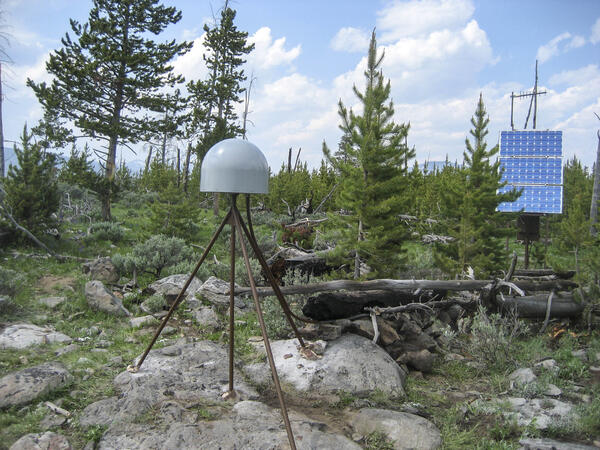
U.S. flag

An official website of the United States government

Images

Images intro.
Filter Total Items: 695
Old Faithful in eruption

Old Faithful Geyser in eruption. Under Yellowstone Research Permit YELL-SCI-8030, 13 mineralized wood specimens were collected from the geyser mound. The dates of the mineralized wood samples imply that such eruptions did not take place for over a century between the mid-13th to mid-14th centuries.

Old Faithful Geyser in eruption. Under Yellowstone Research Permit YELL-SCI-8030, 13 mineralized wood specimens were collected from the geyser mound. The dates of the mineralized wood samples imply that such eruptions did not take place for over a century between the mid-13th to mid-14th centuries.

Grand Prismatic Spring, Midway Geyser Basin, Yellowstone National Park

Grand Prismatic Spring, Midway Geyser Basin, Yellowstone National Park.  Grand Prismatic is the largest hot spring in Yellowstone and the third largest in the world. Photograph by Robert Fournier.

Two photos comparing "cinders" (small spherules) with black cinders on one side and yellow on the other.
Comparison of sulfur "cinders" from two different hot springs in Yellowstone National Park

A comparison of black cinders from Cinder Pool, in Norris Geyser Basin (left), with yellow cinders from an unnamed pool in the West Nymph Creek thermal area (right).  The Cinder Pool cinders are black due to finely dispersed pyrite, whereas the yellow color of cinders from the West Nymph Creek pool is due to the lack of pyrite.

A comparison of black cinders from Cinder Pool, in Norris Geyser Basin (left), with yellow cinders from an unnamed pool in the West Nymph Creek thermal area (right).  The Cinder Pool cinders are black due to finely dispersed pyrite, whereas the yellow color of cinders from the West Nymph Creek pool is due to the lack of pyrite.

Columnar-jointed lava flow in the wall of the Yellowstone River canyon

A 1.5-million-year-old basaltic lava flow in the canyon wall of the Yellowstone River as viewed from Calcite Springs Overlook near Tower Junction in Yellowstone National Park.  Slow cooling of this lava flow resulted in the formation of vertical columns.  Glacial gravels are present above and below the lava flow.

A 1.5-million-year-old basaltic lava flow in the canyon wall of the Yellowstone River as viewed from Calcite Springs Overlook near Tower Junction in Yellowstone National Park.  Slow cooling of this lava flow resulted in the formation of vertical columns.  Glacial gravels are present above and below the lava flow.

A grassland with rolling hills in the background and a blue sky
Grassland area of eastern Wyoming

A photo of a grassland area of eastern Wyoming taken for the Land Cover Trends project by Terry Sohl of the USGS.

A photo of a grassland area of eastern Wyoming taken for the Land Cover Trends project by Terry Sohl of the USGS.

An owl stands in a grassy area
A burrowing owl amid grassland in eastern Wyoming

A burrowing owl amid grassland in eastern Wyoming is captured in a Land Cover Trends photo taken by Terry Sohl of the USGS Earth Resources Observation and Science (EROS) Center.

A burrowing owl amid grassland in eastern Wyoming is captured in a Land Cover Trends photo taken by Terry Sohl of the USGS Earth Resources Observation and Science (EROS) Center.

Sheepeater Cliff, in Yellowstone National Park

Slow cooling of a basaltic lava flow that was erupted about 500,000 years ago resulted in the formation of hexagonal columns at Sheepeater Cliff, in Yellowstone National Park.

Slow cooling of a basaltic lava flow that was erupted about 500,000 years ago resulted in the formation of hexagonal columns at Sheepeater Cliff, in Yellowstone National Park.

Sampling the Snake River at Moose with a bridge crane

Water-quality sampling using a bridge crane on bridge crossing the Snake River at Moose, Grand Teton National Park

map of western U.S.showing sagebrush-dominated ecoregions
Sagebrush-dominated ecoregions

Sagebrush-dominated ecoregions in the western United States (sagebrush cover types shown in various shades of yellow, pink, and blue-grey).

Sagebrush-dominated ecoregions in the western United States (sagebrush cover types shown in various shades of yellow, pink, and blue-grey).

A hinged metal cover, flush with the ground, is open, exposing a metal rod just below the ground surface.
Benchmark T366, north of Canyon Junction in Yellowstone National Park

Benchmark T366, was installed in 1987 a few miles north of Canyon Junction in Yellowstone National Park. Rather than being a brass or aluminum disk, the benchmark is a rod that was driven into the ground until it would not sink any lower.  The precise elevation of the top of the rod was established by surveying methods, and an access cover flush with the g

Benchmark T366, was installed in 1987 a few miles north of Canyon Junction in Yellowstone National Park. Rather than being a brass or aluminum disk, the benchmark is a rod that was driven into the ground until it would not sink any lower.  The precise elevation of the top of the rod was established by surveying methods, and an access cover flush with the g

Boreal toad (Bufo boreas) mating ball, Bridger-Teton National Forest, Wyoming.
Boreal toad (Bufo boreas) mating ball
Geological Map of the Monument Geyser Basin area

Geological Map of the area around Monument Geyser Basin and Beryl Spring, taken from the Geological Map of the Yellowstone Plateau Area (Christiansen, 2001)

Geological Map of the area around Monument Geyser Basin and Beryl Spring, taken from the Geological Map of the Yellowstone Plateau Area (Christiansen, 2001)

Map showing zoom of geology in area of Madison Junction, Yellowstone NP, with red star indicating outcrop location
Map of Yellowstone showing the extent of Lava Creek Tuff and geologic map of Madison Junction area

Left: Map of Yellowstone showing the extent of mapped Lava Creek Tuff members A and B, which erupted during the formation of Yellowstone Caldera about 631,000 years ago. Right: Geologic map of Madison Junction (1:125,000).

Schematic sketch map of mountain ranges  and valleys that might have existed in Yellowstone before 2.2 million years ago
Interpretive reconstruction of the Yellowstone Plateau region before initial plateau volcanism

Interpretive reconstruction of the Yellowstone Plateau region before initial plateau volcanism (a little before 2 million years ago). The region was entirely an elevated and faulted mountainous terrain with no basin in the present plateau area.

Geologists in Little Dipper boat on Grand Prismatic Spring

Yellowstone National Park employees Rick Hutchinson (right) and Jim Peaco (left) guide the specially designed Little Dipper boat into the boiling waters of Grand Prismatic Spring to collect measurements of the temperature and structure of the feature. National Park Service photo by Josh Robbins in 1996.

Yellowstone National Park employees Rick Hutchinson (right) and Jim Peaco (left) guide the specially designed Little Dipper boat into the boiling waters of Grand Prismatic Spring to collect measurements of the temperature and structure of the feature. National Park Service photo by Josh Robbins in 1996.

Queen's Laundry bathhouse, in the Lower Geyser Basin of Yellowstone National Park
Queen's Laundry bathhouse, in Yellowstone's Lower Geyser Basin

Queen's Laundry bathhouse, in the Lower Geyser Basin of Yellowstone National Park.  Building began under superintendent Philetus Norris in 1881 but was never finished.

Was this page helpful?