
Collecting habitat data at 06324970
Images
Images intro.
Filter Total Items: 708

Collecting habitat data at 06324970
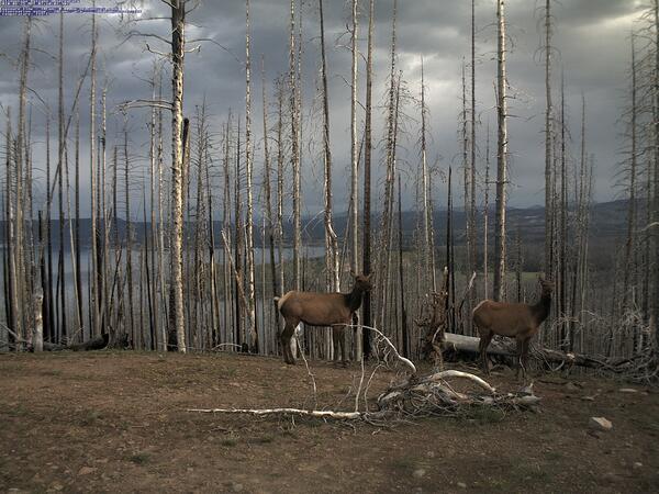
Image of elk captured by the YVO mobile webcam on June 25, 2010
Image of elk captured by the YVO mobile webcam on June 25, 2010Image of elk captured by the YVO mobile webcam on June 25, 2010, when it was positioned atop Lake Butte with a view of the north side of Yellowstone Lake.
Image of elk captured by the YVO mobile webcam on June 25, 2010
Image of elk captured by the YVO mobile webcam on June 25, 2010Image of elk captured by the YVO mobile webcam on June 25, 2010, when it was positioned atop Lake Butte with a view of the north side of Yellowstone Lake.

Preparing sample for macroinvertebrate analysis
Preparing sample for macroinvertebrate analysis

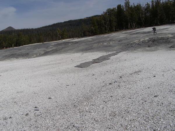
Overview of central West Thumb Geyser Basin
Overview of central West Thumb Geyser Basin. USGS photo by Pat Shanks, 2009.
Overview of central West Thumb Geyser Basin. USGS photo by Pat Shanks, 2009.

Photo of the Madison Museum, Yellowstone National Park
Photo of the Madison Museum, Yellowstone National ParkPhoto of the Madison Museum, built in 1930 and designed by Herbert Maier. This structure exemplifies the National Park Rustic style, using natural materials and artisan craftmanship that are intended to blend buildings into the surrounding environment, “suggesting the smallness of man in relation to nature” (Herbert Maier).

Measuring water level in streambank piezometer nr Wind Riv at Kinnear
Measuring water level in streambank piezometer nr Wind Riv at KinnearMeasuring water level in streambank piezometer nr Wind River at Kinnear
Measuring water level in streambank piezometer nr Wind Riv at Kinnear
Measuring water level in streambank piezometer nr Wind Riv at KinnearMeasuring water level in streambank piezometer nr Wind River at Kinnear

Bob Fournier measuring the gas-to-water ratio (gas/steam) at drill site Y2 in Yellowstone National Park
Bob Fournier measuring the gas-to-water ratio (gas/steam) at drill site Y2 in Yellowstone National ParkBob Fournier measuring the gas-to-water ratio (gas/steam) at drill site Y2, near Hot Lake on Firehole Lake Drive in Lower Geyser Basin, Yellowstone National Park, in the late 1960s. USGS Photo.

Coyote on trail to Canyon, Wyoming
Coyote on trail to Canyon, Wyoming
Coyote on trail to Canyon, Wyoming

Yellowstone caldera viewed from Mount Washburn
Yellowstone caldera viewed from Mount Washburn. The caldera is the low-lying area extending from the foothills of Mount Washburn in the foreground to the rugged mountains on the horizon. The incised valley of the Yellowstone River stretches from left to right in the middle distance. Steep valley walls are illuminated by sunlight in the center. 
Yellowstone caldera viewed from Mount Washburn. The caldera is the low-lying area extending from the foothills of Mount Washburn in the foreground to the rugged mountains on the horizon. The incised valley of the Yellowstone River stretches from left to right in the middle distance. Steep valley walls are illuminated by sunlight in the center. 

Well sampled for baseline pesticide concentrations in groundwater
Well sampled for baseline pesticide concentrations in groundwaterWell sampled to determine baseline pesticide concentrations in groundwater.
Well sampled for baseline pesticide concentrations in groundwater
Well sampled for baseline pesticide concentrations in groundwaterWell sampled to determine baseline pesticide concentrations in groundwater.

Workers access site at Divide Peak, Wyoming via snowmobile.
Workers access site at Divide Peak, Wyoming via snowmobile.Workers access site at Divide Peak, Wyoming via snowmobile.
Workers access site at Divide Peak, Wyoming via snowmobile.
Workers access site at Divide Peak, Wyoming via snowmobile.Workers access site at Divide Peak, Wyoming via snowmobile.

Worker in snowpack-sampling pit at Old Battle, Wyoming
Worker in snowpack-sampling pit at Old Battle, WyomingWorker in snowpack-sampling pit at Old Battle, Wyoming
Worker in snowpack-sampling pit at Old Battle, Wyoming
Worker in snowpack-sampling pit at Old Battle, WyomingWorker in snowpack-sampling pit at Old Battle, Wyoming

National Atmospheric Deposition site near Gypsum Creek, Wyoming.
National Atmospheric Deposition site near Gypsum Creek, Wyoming.National Atmospheric Deposition site near Gypsum Creek, Wyoming.
National Atmospheric Deposition site near Gypsum Creek, Wyoming.
National Atmospheric Deposition site near Gypsum Creek, Wyoming.National Atmospheric Deposition site near Gypsum Creek, Wyoming.

Buffalo on road to Canyon, Wyoming
Buffalo on road to Canyon, Wyoming
Buffalo on road to Canyon, Wyoming

An inquisitive Yellow-bellied Marmot stands on its hind legs, in Yellowstone National Park.
An inquisitive Yellow-bellied Marmot stands on its hind legs, in Yellowstone National Park.Yellow-bellied Marmot stands on its hind legs in Yellowstone National Park. Photo by D. Dzurisin.
An inquisitive Yellow-bellied Marmot stands on its hind legs, in Yellowstone National Park.
An inquisitive Yellow-bellied Marmot stands on its hind legs, in Yellowstone National Park.Yellow-bellied Marmot stands on its hind legs in Yellowstone National Park. Photo by D. Dzurisin.

Terrace Springs, northeast of Madison Junction, Yellowstone National Park
Terrace Springs, northeast of Madison Junction, Yellowstone National ParkThe water at Terrace Springs, northeast of Madison Junction in Yellowstone National Park, is relatively cold (about 60 °C or 140 °F), but the water is still saturated with CO2-rich bubbles. Photo by Shaul Hurwitz in September 2008.
Sulfur flow at Brimstone Basin, Yellowstone National Park
Sulfur flow at Brimstone Basin, Yellowstone National ParkA sulfur flow over acid-sulfate ground at Brimstone Basin near the eastern shore of Yellowstone Lake. The flows formed when native sulfur deposits were ignited during a forest fire. Photo by Shaul Hurwitz, September 2008.

Measuring streamflow in Fish Creek with large Cladophora growth
Measuring streamflow in Fish Creek with large Cladophora growthMeasuring streamflow in Fish Creek with large Cladophora growth
Measuring streamflow in Fish Creek with large Cladophora growth
Measuring streamflow in Fish Creek with large Cladophora growthMeasuring streamflow in Fish Creek with large Cladophora growth

Roadcut in the Lava Creek Tuff near Tuff Cliff, Yellowstone National Park
Roadcut in the Lava Creek Tuff near Tuff Cliff, Yellowstone National ParkRoadcut in light pink ash-flow deposits of the Lava Creek Tuff on Grand Loop Road near Tuff Cliff. The color and closely spaced jointing are characteristic of the Lava Creek Tuff map unit. The steep faces and dense nature of the roadcut exposures indicate that a moderate degree of welding occurred and has not been subsequently modified by hydrothermal al

Lower Falls and Grand Canyon of the Yellowstone River
Lower Falls and Grand Canyon of the Yellowstone RiverLower Falls and Grand Canyon of the Yellowstone River. The river here is eroding young, post-caldera rhyolite that was softened by hydrothermal alteration. The V shape of the canyon indicates that the river is actively eroding in response to regional uplift. Photo by Richard Tollo, George Washington University, August 12, 2008.

Narrow Gauge spring, Mammoth Hot Springs, Yellowstone National Park
Narrow Gauge spring, Mammoth Hot Springs, Yellowstone National ParkNarrow Gauge spring, Mammoth Hot Springs, Yellowstone National Park. Vent area is between the two trees on top of the travertine deposits. Terraced pools form due to deposition of travertine from the fluids as they cool and degas carbon dioxide.