Prioritizing Marsh Restoration Needs Throughout Chesapeake Bay
Evaluating the Risks of Tire-Derived Compounds to Fish in the Chesapeake Bay Watershed
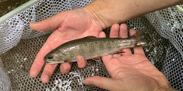
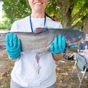
Regional Assessment of Fish Health in the Chesapeake Bay Watershed
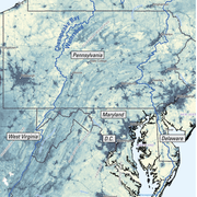
Informing Freshwater Management Strategies in the Chesapeake Bay Watershed by Using Observational Data and Expert Knowledge to Identify Influential Stressors
The Nonpoint Source Challenge:
Obstacles and Opportunities for Meeting Nutrient Reduction Goals in the Chesapeake Bay Watershed
Informing Chesapeake Bay Watershed Management by Monitoring Trends in River Nutrient and Sediment Loads
Discovering Connections Across America's Lands and Waters
Road salt elevates salinity above background levels in freshwater streams and rivers across the Chesapeake Bay Watershed
Publications
Discover Chesapeake related science in reports and journal articles authored by USGS scientists
Chesapeake Bay Activities
The Chesapeake Bay is our Nation’s largest estuary and provides over $100 billion in annual economic value. The USGS works with Federal, State, local, and academic partners to provide research and monitoring and to communicate results to inform management for the Chesapeake and other important landscapes across the Nation.
Accomplishments in 2025
Central to our mission is communicating decision-ready science to help partners better manage lands, water, and wildlife in the Chesapeake Bay watershed. Read more about our accomplishments that were used to inform management decisions and advance Department of the Interior priorities.
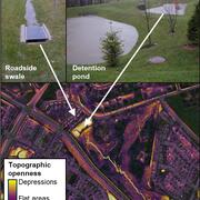
Mapping Stormwater Facility Footprints
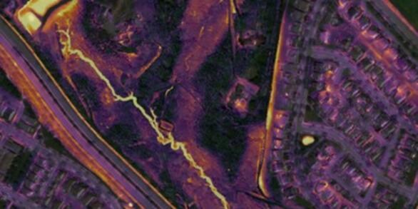
USGS is working to develop an artificial intelligence/machine learning (AI/ML) deep learning model to remotely map the footprint of stormwater facilities and estimate a storage volume for each facility using high-resolution geospatial data layers.
Quick Links
Learn more about USGS science activities in the Bay from our Science Strategy. Additional summaries of the USGS Chesapeake Bay Activities are available in the science topics section.
News
Maryland Mainstem Tributary Summary
Study offers best picture yet of sinking land in the Chesapeake Bay region
Chesapeake Bay Program partners protect more than 9.2 million acres of land across watershed
Publications
Assessing streams in the Chesapeake Bay Watershed to guide conservation and restoration activities Assessing streams in the Chesapeake Bay Watershed to guide conservation and restoration activities
Using monitoring and partnerships to provide management-relevant information about Chesapeake Bay rivers Using monitoring and partnerships to provide management-relevant information about Chesapeake Bay rivers
A simple predictive model for salt marsh internal deterioration under sea-level rise and sediment deficits: Application to Chesapeake Bay A simple predictive model for salt marsh internal deterioration under sea-level rise and sediment deficits: Application to Chesapeake Bay
Science
USGS Chesapeake Bay Science Accomplishments for 2025
Remotely mapping stormwater facility footprints and storage volumes