
A mesmerizing plume creates a paradox of light and dark, brilliant and murky. The dark water of the Suwannee River flows from the Okefenokee Swamp in southern Georgia to the Gulf of America in Florida. The river’s inky color comes from decaying vegetation at the river’s swampy source.
Images
Peruse our selection of remote sensing and Earth science imagery below.
Filter Total Items: 871

Luminescence
A mesmerizing plume creates a paradox of light and dark, brilliant and murky. The dark water of the Suwannee River flows from the Okefenokee Swamp in southern Georgia to the Gulf of America in Florida. The river’s inky color comes from decaying vegetation at the river’s swampy source.

Earth Selfie
The tendency to recognize human faces in things that are not human is common. Can you see the eye, nose, and mouth in this satellite image of Morocco? The face captured in this "Earth Selfie" appears to be quietly watching over the waters just off its coast. The city of Agadir is underneath the chin, and the irrigated farms of the Souss Valley appear in red.
The tendency to recognize human faces in things that are not human is common. Can you see the eye, nose, and mouth in this satellite image of Morocco? The face captured in this "Earth Selfie" appears to be quietly watching over the waters just off its coast. The city of Agadir is underneath the chin, and the irrigated farms of the Souss Valley appear in red.
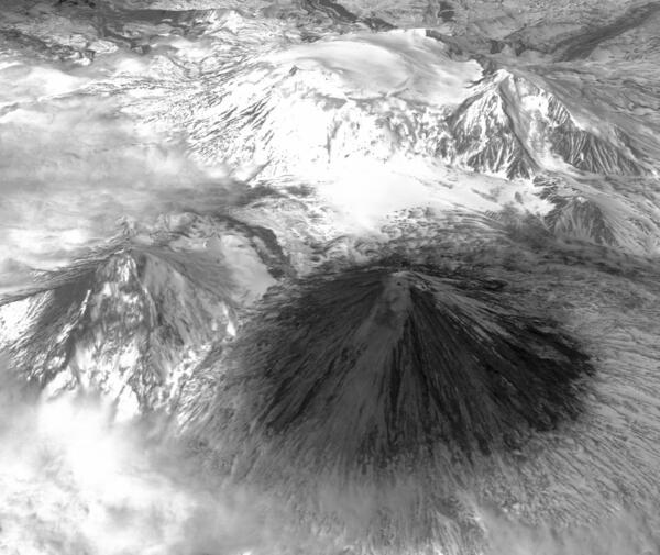
ASTER image of Sheveluch volcano covered in ash on Russia's Kamchatka peninsula
ASTER image of Sheveluch volcano covered in ash on Russia's Kamchatka peninsulaThis ASTER image of the Sheveluch volcano covered in ash atop the snow cover of winter on Russia's Kamchatka peninsula was captured in 2014 after recent eruptions. ASTER (Advanced Spaceborne Thermal Emission and Reflection Radiometer) is an instrument, resulting from a U.S. and Japanese partnership, that is aboard NASA's Terra satellite.
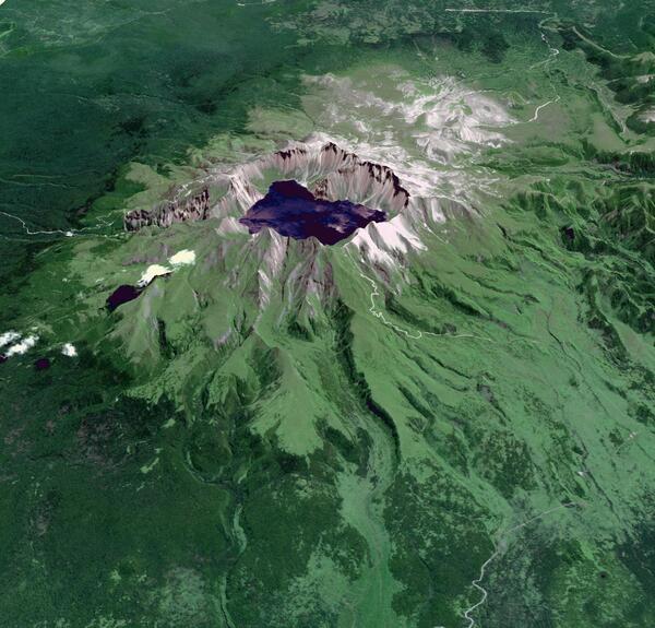
ASTER image of Baektu Mountain, an active volcano on the border between North Korea and China
ASTER image of Baektu Mountain, an active volcano on the border between North Korea and ChinaA 2014 ASTER image of Baektu Mountain, an active volcano on the border between North Korea and China. The crater lake at the summit is called Heaven Lake. ASTER (Advanced Spaceborne Thermal Emission and Reflection Radiometer) is an instrument, resulting from a U.S. and Japanese partnership, that is aboard NASA's Terra satellite.

Australian Iron Ore
Within the Hamersley Iron Province in Western Australia, Landsat's shortwave infrared and near-infrared detectors highlight different types of rock. The oval in the upper center part of the image is a geological feature called Rocklea Dome. The dark meanders within the dome are channel iron deposits.
Within the Hamersley Iron Province in Western Australia, Landsat's shortwave infrared and near-infrared detectors highlight different types of rock. The oval in the upper center part of the image is a geological feature called Rocklea Dome. The dark meanders within the dome are channel iron deposits.

Melted Colors
This enhanced image of Western Australia resembles a mixture of crayons that melted in the sun. The yellow sand dunes of the Great Sandy Desert cover the upper right portion of the image. Red splotches indicate burned areas from grass and forest fires, and the colors in the rest of the image depict different types of surface geology.
This enhanced image of Western Australia resembles a mixture of crayons that melted in the sun. The yellow sand dunes of the Great Sandy Desert cover the upper right portion of the image. Red splotches indicate burned areas from grass and forest fires, and the colors in the rest of the image depict different types of surface geology.

Salt Glaciers
The patterns and colors in the Zagros Mountains of Iran are interesting enough. For example, the infrared view provides a patina-like outline to the mountains. But something more happened to this unique landscape. Interrupting the mountain patterns are irregular dark patches called salt glaciers.
The patterns and colors in the Zagros Mountains of Iran are interesting enough. For example, the infrared view provides a patina-like outline to the mountains. But something more happened to this unique landscape. Interrupting the mountain patterns are irregular dark patches called salt glaciers.

Slessor Glacier
Slessor Glacier in Antarctica flows between the angular promontory Parry Point on the top left of the image and the Shackleton Range on the lower right. The purple highlights are exposed ice. Strong winds blow away the snow cover and expose lines that indicate the glacier flow direction. Rock outcrops next to the glacier also exhibit some of this bare ice.
Slessor Glacier in Antarctica flows between the angular promontory Parry Point on the top left of the image and the Shackleton Range on the lower right. The purple highlights are exposed ice. Strong winds blow away the snow cover and expose lines that indicate the glacier flow direction. Rock outcrops next to the glacier also exhibit some of this bare ice.
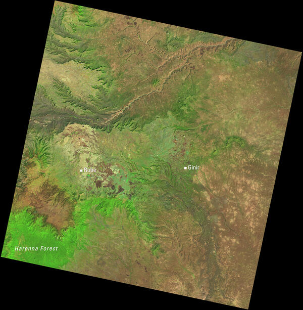
Landsat View of Ethiopia’s Highlands and the Harenna Forest
Landsat View of Ethiopia’s Highlands and the Harenna ForestThis Landsat 8 image of central Ethiopia, acquired January 1, 2014, uses the shortwave infrared, near infrared, and red spectral bands (bands 6,5,4) to emphasize vegetation and land cover. In this combination, healthy vegetation appears bright green.

Scorpion Reef
Is this a tiny creature on a microscope slide? No, but you are close. This is an image of a structure built by a multitude of small creatures. At about 21 kilometers (13 miles) wide, this feature is the largest coral structure in the southern Gulf of America.
Is this a tiny creature on a microscope slide? No, but you are close. This is an image of a structure built by a multitude of small creatures. At about 21 kilometers (13 miles) wide, this feature is the largest coral structure in the southern Gulf of America.

Land of Terror
No water. No vegetation. No oases. Known as the "Land of Terror," the Tanezrouft Basin in Algeria is one of the most desolate parts of the Sahara Desert. Sand dunes, which appear in yellow, streak down the left side of the image, and sandstone formations carved by relentless wind erosion make concentric loops, much like the grain seen in a piece of wood.
No water. No vegetation. No oases. Known as the "Land of Terror," the Tanezrouft Basin in Algeria is one of the most desolate parts of the Sahara Desert. Sand dunes, which appear in yellow, streak down the left side of the image, and sandstone formations carved by relentless wind erosion make concentric loops, much like the grain seen in a piece of wood.

Sloppy Paint Job
What appear to be smatterings of paint on a wall represent an amalgam of human-made and natural features in southwestern Iran. The dark red shape in the center of the image is Shadegan Pond, which is the northern part of the larger Shadegan Wetlands.
What appear to be smatterings of paint on a wall represent an amalgam of human-made and natural features in southwestern Iran. The dark red shape in the center of the image is Shadegan Pond, which is the northern part of the larger Shadegan Wetlands.

Mulanje Massif
In southern Malawi, the erosion-resistant rock of Mulanje Massif, a large mountain mass, rises dramatically above the landscape near Lake Chilwa, a shallow, saline lake. The upper slopes of the massif are protected forest. The deep green color south of the massif is tea and macadamia farms.
In southern Malawi, the erosion-resistant rock of Mulanje Massif, a large mountain mass, rises dramatically above the landscape near Lake Chilwa, a shallow, saline lake. The upper slopes of the massif are protected forest. The deep green color south of the massif is tea and macadamia farms.

Cloud Lightning
What looks like lightning arcing through an ominous cloud is actually a dry landscape of rocky buttes in southern Utah and northeastern Arizona. River channels flow north from Arizona into the San Juan River. The light vertical feature at the top of the image is referred to as Comb Ridge, a jagged fold in the Earth's crust called a monocline.
What looks like lightning arcing through an ominous cloud is actually a dry landscape of rocky buttes in southern Utah and northeastern Arizona. River channels flow north from Arizona into the San Juan River. The light vertical feature at the top of the image is referred to as Comb Ridge, a jagged fold in the Earth's crust called a monocline.

Oxbows in Bolivia
The Beni River in Bolivia resembles a blue ribbon as it meanders toward the Amazon River. Scattered along the river are numerous oxbow lakes, which are curved bodies of water that form when a meander from the main stem of a river is cut off, creating a freestanding body of water.
The Beni River in Bolivia resembles a blue ribbon as it meanders toward the Amazon River. Scattered along the river are numerous oxbow lakes, which are curved bodies of water that form when a meander from the main stem of a river is cut off, creating a freestanding body of water.

Earth’s Aquarium
These green and blue swirls in the Bering Sea reveal the bottom of the food chain in the ocean. Microscopic organisms called phytoplankton, which are important to fish populations, may be too small to be seen individually, but in vast numbers they are visible from space. The white clouds in the image look like bubbles in an aquarium.
These green and blue swirls in the Bering Sea reveal the bottom of the food chain in the ocean. Microscopic organisms called phytoplankton, which are important to fish populations, may be too small to be seen individually, but in vast numbers they are visible from space. The white clouds in the image look like bubbles in an aquarium.

Scientists Explore Hawaii's Coast
Coral growth offshore of the Hawaiian Island of Kahoʻolawe has been significantly impacted by the island's deforestation and resulting erosion and sediment run-off into the nearshore environment. This image is of a coral reef in deeper waters offshore of Kahoʻolawe.
Coral growth offshore of the Hawaiian Island of Kahoʻolawe has been significantly impacted by the island's deforestation and resulting erosion and sediment run-off into the nearshore environment. This image is of a coral reef in deeper waters offshore of Kahoʻolawe.

Putrid Sea
Varied types of microalgae flourish in this colorful network of shallow, salty lagoons at the neck of the Crimean Peninsula between the Black Sea and the Sea of Azov. This natural color image portrays the unnaturally strange colors of the area known as Sivash, which is nicknamed the "putrid sea" because the algae in some of the lagoons produce a rotten smell.
Varied types of microalgae flourish in this colorful network of shallow, salty lagoons at the neck of the Crimean Peninsula between the Black Sea and the Sea of Azov. This natural color image portrays the unnaturally strange colors of the area known as Sivash, which is nicknamed the "putrid sea" because the algae in some of the lagoons produce a rotten smell.

Tessera Mosaic
The Tietê River snakes across this tessera mosaic of multicolored shapes near Ibitinga, Brazil. Fields of sugarcane, peanuts, and corn vary in their stages of development. Lavender, purple, and bright blue indicate actively growing crops. Light yellow or white indicate little or no vegetation growth. The splotches of dark mustard yellow are urban areas.
The Tietê River snakes across this tessera mosaic of multicolored shapes near Ibitinga, Brazil. Fields of sugarcane, peanuts, and corn vary in their stages of development. Lavender, purple, and bright blue indicate actively growing crops. Light yellow or white indicate little or no vegetation growth. The splotches of dark mustard yellow are urban areas.

Life along the Nile
It is easy to see from this image why people have been drawn to the Nile River in Egypt for thousands of years. Green farmland marks a distinct boundary between the Nile floodplain and the surrounding harsh desert.
It is easy to see from this image why people have been drawn to the Nile River in Egypt for thousands of years. Green farmland marks a distinct boundary between the Nile floodplain and the surrounding harsh desert.

Landsat 8 captures snow-covered Tibetan peaks, August 2014
Landsat 8 captures snow-covered Tibetan peaks, August 2014This false-color Landsat 8 image shows valleys and snow-covered mountain ranges in southeastern Tibet. It was captured on August 4, 2014.
Landsat 8 captures snow-covered Tibetan peaks, August 2014
Landsat 8 captures snow-covered Tibetan peaks, August 2014This false-color Landsat 8 image shows valleys and snow-covered mountain ranges in southeastern Tibet. It was captured on August 4, 2014.