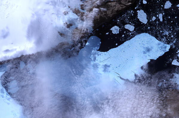
U.S. flag

An official website of the United States government

Images

Peruse our selection of remote sensing and Earth science imagery below.

Filter Total Items: 862
Image: Comparison of Aerial Photo and LiDAR Image
Comparison of Aerial Photo and LiDAR Image

Comparison of color aerial photography with airborne light detection and ranging (LiDAR) imagery in an area west of Lake Tahoe, California. (A) Color aerial orthophoto for part of range front along eastern base of Mt. Tallac with geomorphic features obscured by dense forest cover. (B) Same scene, first-return LiDAR imagery.

Comparison of color aerial photography with airborne light detection and ranging (LiDAR) imagery in an area west of Lake Tahoe, California. (A) Color aerial orthophoto for part of range front along eastern base of Mt. Tallac with geomorphic features obscured by dense forest cover. (B) Same scene, first-return LiDAR imagery.

Earth As Art image Roof of the World
Roof of the World
Roof of the World
Roof of the World

Central Asia's Tibetan Plateau is justifiably nicknamed "the roof of the world"-its average elevation is more than 4,500 meters (14,764 feet). It is the world's highest and largest plateau, covering an area roughly four times the size of Texas. Tectonic forces have long shaped the Tibetan Plateau's crumpled and uplifted mountain ridges.

Central Asia's Tibetan Plateau is justifiably nicknamed "the roof of the world"-its average elevation is more than 4,500 meters (14,764 feet). It is the world's highest and largest plateau, covering an area roughly four times the size of Texas. Tectonic forces have long shaped the Tibetan Plateau's crumpled and uplifted mountain ridges.

Earth As Art image Island Rebound
Island Rebound
Island Rebound
Island Rebound

During the last ice age, Akimiski Island in Canada's James Bay lay beneath vast glaciers that pressed down with immense force. As the climate changed and the ice retreated, Akimiski began a gradual rebound.

During the last ice age, Akimiski Island in Canada's James Bay lay beneath vast glaciers that pressed down with immense force. As the climate changed and the ice retreated, Akimiski began a gradual rebound.

Earth As Art image Remote Tundra
Remote Tundra
Remote Tundra
Remote Tundra

Skeletal extensions of land reach like bony fingers across a section of Liverpool Bay along the northern edge of Canada's Northwest Territories. Only small villages are thinly scattered in this remote and inhospitable region of Arctic tundra bordering the Beaufort Sea.

Skeletal extensions of land reach like bony fingers across a section of Liverpool Bay along the northern edge of Canada's Northwest Territories. Only small villages are thinly scattered in this remote and inhospitable region of Arctic tundra bordering the Beaufort Sea.

Landsat 7 Image of Washington DC and Baltimore area

This Landsat 7 image captures the Washington, D.C., and Baltimore, MD, areas. Washington, D.C., lies in the center of the image along the Potomac River. Baltimore, in the upper-right portion of the image, is located on the western shore of Chesapeake Bay.

Landsat Missions Web Site

This Landsat 7 image captures the Washington, D.C., and Baltimore, MD, areas. Washington, D.C., lies in the center of the image along the Potomac River. Baltimore, in the upper-right portion of the image, is located on the western shore of Chesapeake Bay.

Landsat Missions Web Site

Earth As Art image, San Luis, Argentina
San Luis, Argentina
San Luis, Argentina
San Luis, Argentina

Straight highways fan out like spokes on a wheel from the Argentine city of San Luis. To the right of the city are croplands that resemble colorful confetti. Founded in 1594, San Luis lies at the tip of the Sierra de San Luis and is largely surrounded by flat-to-rolling fertile plains.

Straight highways fan out like spokes on a wheel from the Argentine city of San Luis. To the right of the city are croplands that resemble colorful confetti. Founded in 1594, San Luis lies at the tip of the Sierra de San Luis and is largely surrounded by flat-to-rolling fertile plains.

A grassland with a barbed wire fence in the foreground and a rolling hill in the distant background
Montana grassland in a USGS Land Cover Trends photo
A cloudy sky above farmland striped with crops and dirt and a gravel road in one corner
USGS Land Cover Trends photo of Montana cropland

A 2006 photo taken on a USGS Land Cover Trends trip in Montana showing strips of cropland with fallow land in between.

Dead trees stand along the edge of a lake with grass inside a fence in the foreground and a cloudy sky above
Lake with submerged trees in Day County, South Dakota

A lake with submerged trees in Day County, South Dakota, part of the Prairie Pothole Region. 2006 photo from the USGS Land Cover Trends project

A flat landscape with grasses, a part of a fence in the foreground and a farmstead far in the background
USGS Land Cover Trends photo in Montana

USGS Land Cover Trends photo in Montana in 2006 of land enrolled in the Conservation Reserve Program.

A landscape with grass and a few trees in the foreground, an irregular body of water and forest behind the water
Waubay National Wildlife Refuge in Day County, South Dakota

The Waubay National Wildlife Refuge in Day County, South Dakota, is in the Prairie Pothole Region and includes Waubay Lake. 2006 photo from the USGS Land Cover Trends project

The Waubay National Wildlife Refuge in Day County, South Dakota, is in the Prairie Pothole Region and includes Waubay Lake. 2006 photo from the USGS Land Cover Trends project

Earth As Art image Sor Kaydak
Sor Kaydak
Sor Kaydak
Sor Kaydak

The intricate lines angling and criss-crossing over the landscape are roads in extreme southwestern Kazakhstan. The turquoise areas to the left are salt flats and marshes, some parts of which are submerged (dark blue). The water body is Sor Kaydak, which was once a gulf of the Caspian Sea.

The intricate lines angling and criss-crossing over the landscape are roads in extreme southwestern Kazakhstan. The turquoise areas to the left are salt flats and marshes, some parts of which are submerged (dark blue). The water body is Sor Kaydak, which was once a gulf of the Caspian Sea.

Earth As Art image Lake Eyre
Lake Eyre
Lake Eyre
Lake Eyre

Do you see a scary face looking back at you? The hollow-appearing eyes, narrow nose, and slash of a mouth are inundated patches of shallow Lake Eyre (pronounced "air"). Deep in the desert country of northern South Australia, Lake Eyre is an ephemeral feature of this flat, parched landscape. When seasonal rains are abundant, water fills the lakebed to some degree.

Do you see a scary face looking back at you? The hollow-appearing eyes, narrow nose, and slash of a mouth are inundated patches of shallow Lake Eyre (pronounced "air"). Deep in the desert country of northern South Australia, Lake Eyre is an ephemeral feature of this flat, parched landscape. When seasonal rains are abundant, water fills the lakebed to some degree.

Earth As Art image Lake District
Lake District
Lake District
Lake District

A popular holiday destination, the Lake District in northwestern England is a region of picturesque mountains and long, narrow lakes. Most of the lakes lie in U-shaped valleys that were carved by glaciers during the last ice age. Morecambe Bay, below the Lake District, opens into the Irish Sea.

A popular holiday destination, the Lake District in northwestern England is a region of picturesque mountains and long, narrow lakes. Most of the lakes lie in U-shaped valleys that were carved by glaciers during the last ice age. Morecambe Bay, below the Lake District, opens into the Irish Sea.

Farmland near Hydetown, PA

Farmland near Hydetown, Pennsylvania, part of the Erie Drift Plain Ecoregion. This photo was taken during fieldwork for the USGS Land Cover Trends project. The project was focused on understanding the rates, trends, causes, and consequences of contemporary U.S.

Farmland near Hydetown, Pennsylvania, part of the Erie Drift Plain Ecoregion. This photo was taken during fieldwork for the USGS Land Cover Trends project. The project was focused on understanding the rates, trends, causes, and consequences of contemporary U.S.

Earth As Art image Van Gogh from Space
Van Gogh from Space
Van Gogh from Space
Van Gogh from Space

In the style of Van Gogh's painting "Starry Night," massive congregations of greenish phytoplankton swirl in the dark water around Gotland, a Swedish island in the Baltic Sea. Phytoplankton are microscopic marine plants that form the first link in nearly all ocean food chains.

In the style of Van Gogh's painting "Starry Night," massive congregations of greenish phytoplankton swirl in the dark water around Gotland, a Swedish island in the Baltic Sea. Phytoplankton are microscopic marine plants that form the first link in nearly all ocean food chains.

Earth As Art image Siberian Ribbons
Siberian Ribbons
Siberian Ribbons
Siberian Ribbons

Vivid colors and bizarre shapes come together in an image that could be an imaginative illustration for a fantasy story. This labyrinth of exotic features is present along the edge of Russia's Chaunskaya Bay (vivid blue half circle) in northeastern Siberia. Two major rivers, the Chaun and Palyavaam, flow into the bay, which in turn opens into the Arctic Ocean.

Vivid colors and bizarre shapes come together in an image that could be an imaginative illustration for a fantasy story. This labyrinth of exotic features is present along the edge of Russia's Chaunskaya Bay (vivid blue half circle) in northeastern Siberia. Two major rivers, the Chaun and Palyavaam, flow into the bay, which in turn opens into the Arctic Ocean.

color photograph
Senegal landscape - 1994

A landscape scene in Senegal, photographed in 1994 by U.S. Geological Survey Scientist G. Gray Tappan as part of his work on West African land cover. Tappan previously photographed the scene in 1983.

A landscape scene in Senegal, photographed in 1994 by U.S. Geological Survey Scientist G. Gray Tappan as part of his work on West African land cover. Tappan previously photographed the scene in 1983.

color photograph
Senegal landscape - 1983

A landscape scene in Senegal, photographed in 1983 by U.S. Geological Survey Scientist G. Gray Tappan as part of his work on West African land cover. Tappan photographed the scene again in 1994.

A landscape scene in Senegal, photographed in 1983 by U.S. Geological Survey Scientist G. Gray Tappan as part of his work on West African land cover. Tappan photographed the scene again in 1994.

Was this page helpful?