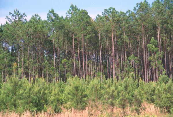
This satellite mosaic of the Hoosier State was created from several Landsat scenes stitched together to create one seamless image. Data from the National Elevation Dataset (NED) is also incorporated into the image. The names of major cities and county boundaries have been added.
Images
Peruse our selection of remote sensing and Earth science imagery below.
This satellite mosaic of the Hoosier State was created from several Landsat scenes stitched together to create one seamless image. Data from the National Elevation Dataset (NED) is also incorporated into the image. The names of major cities and county boundaries have been added.
A giant whirlpool cloud, coaxed into shape by high-altitude winds, swirls above the sea between Spain and Morocco.
142 million years ago, an asteroid or comet slammed into what is now the Missionary Plains in Australia's Northern Territory, forming a crater 24 kilometers in diameter and 5 kilometers deep. Today, like a bull's eye, the circular ring of hills that defines Gosses Bluff stands as a stark reminder of the event.
Like distant galaxies amid clouds of interstellar dust, chunks of sea ice drift through graceful swirls of grease ice in the frigid waters of Foxe Basin near Baffin Island in the Canadian Arctic. Sea ice often begins as grease ice, a soupy slick of tiny ice crystals on the ocean's surface.
As air flows over and around objects in its path, spiraling eddies, known as Von Karman vortices, may form. The vortices in this image were created when prevailing winds sweeping east across the northern Pacific Ocean encountered Alaska's Aleutian Islands.
Named after the ancient Mayan Province of Kimpech, the state of Campeche comprises much of the western half of Mexico's Yucatan Peninsula. Rivers in southern Campeche drain into the immense Terminos Lagoon, the entrance to which is protected by a long barrier island, Isla Del Carmen.
A vast alluvial fan blossoms across the desolate landscape between the Kunlun and Altun mountain ranges that form the southern border of the Taklimakan Desert in China’s XinJiang Province.
Like dark fingers, cold ocean waters reach deeply into the mountainous coastline of northern Norway, defining the fjords for which the country is famous. Flanked by snow-capped peaks, some of these ice-sculpted fjords are hundreds of meters deep.
Mimicking a cubist collage, linear windbreaks of densely planted trees surround farmsteads in this winter landscape near the city of Komsomolets in Northern Kazakhstan.
The mountainous outcrops of Jebel Auenat rise 6000 feet above the barren, uninhabited plains of the Libyan Desert. The frontiers of Libya, Egypt and Sudan meet amidst the rugged granite of Jebel Auenat. The mountains are remnants of an ancient granitic dome. Rivers of sand meander around them, swept across the desert pavement by northeasterly winds.
The eastern side of Russia's Kamchatka Peninsula juts into the Pacific Ocean west of Alaska. In this winter image, a volcanic terrain is hidden under snow-covered peaks and valley glaciers feed blue ice into coastal waters.
Steep-sided volcanic cones along the Chilean-Argentinean border add texture to this "study in blues." Of approximately 1,800 volcanoes scattered across this region, 28 are active.
Like a many-faceted jewel fashioned in an indigo setting, the Shetland Islands lie 210 kilometers north of the Scottish mainland in the North Atlantic Ocean. Despite their 60 degree north latitude, the Shetlands enjoy a relatively temperate climate thanks to the warming influence of the Gulf Stream.
Vivid colors belie the arid landscape of northern Chile where the Atacama Desert, one of the world's driest, meets the foothills of the Andes. Here salt pans and gorges choked with mineral-streaked sediments give way to white-capped volcanoes.
Like sweeping brushstrokes of pink and green, the Belcher Islands meander across the deep blue of Canada's Hudson Bay. The islands' only inhabitants live in the small town of Sanikiluaq, near the upper end of the middle island. Despite the green hues in this image, these rocky islands are too cold to sustain more than a smattering of low-growing vegetation.
Landsat Records Historic World Trade Center Attack
Landsat Records Historic World Trade Center AttackThis true-color image was taken by the Enhanced Thematic Mapper Plus (ETM+) sensor aboard the Landsat 7 satellite on September 12, 2001, at roughly 11:30 a.m. Eastern Daylight Savings Time. A day after the attack, smoke continues to billow out of the collapsed Twin Towers.
Located on the Italian island of Sicily, Mt. Etna is one of the world's most active volcanoes. In this image of the volcano in 2001, a plume of steam and smoke rising from the crater drifts over some of the many dark lava flows that cover its slopes.
The prominent crimson streak in the center of this image represents the remains of an extensive lava and mud flow. Its source is the currently dormant Anyuyskiy Volcano orange circular shape at the right end of the streak) in northeastern Russia.
Extensive wetlands lie near the town of Yellowknife, near the Great Slave Lake in Northwest Territories, Canada. The shallow lakes seen in this image have formed in grooves in the landscape that were carved by glaciers during the last Ice Age.
Path of 2001 Siren, Wisconsin, tornado on a Landsat 7 image
Path of 2001 Siren, Wisconsin, tornado on a Landsat 7 imageThis labeled Landsat 7 image from June 19, 2001, shows the path of damage caused by a June 18, 2001, tornado that passed near Siren, Wisconsin.
Path of 2001 Siren, Wisconsin, tornado on a Landsat 7 image
Path of 2001 Siren, Wisconsin, tornado on a Landsat 7 imageThis labeled Landsat 7 image from June 19, 2001, shows the path of damage caused by a June 18, 2001, tornado that passed near Siren, Wisconsin.
These are the Anti-Atlas Mountains, part of the Atlas Mountain range in southern Morocco, Africa. The region contains some of the world's largest and most diverse mineral resources, most of which are still untouched.