
Monitoring
Monitoring
Filter Total Items: 32
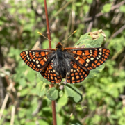
Using environmental DNA monitoring to find an extremely endangered butterfly
The USGS, U.S. Fish and Wildlife Service, and partners are working together to find the elusive checkerspot butterfly.

Land Treatment Exploration Tool
The Land Treatment Exploration Tool provides a practical resource for managers who are planning restoration and rehabilitation actions on public lands. The tool generates a variety of spatial products while being user friendly for all levels of GIS expertise, even to those with little or no experience.

USGS Sagebrush Science: Supporting Public Safety and Economic Decision Making Across the West
The sagebrush biome is one of the largest ecosystems in North America. Encompassing nearly one-third of the continental U.S., it provides critical resources for millions of Americans and a home for hundreds of plants and animal species in the West. Natural resource management in sagebrush ecosystems can be complex, and science can support management decisions by providing knowledge and tools to...
By
Core Science Systems Mission Area, Ecosystems Mission Area, Biological Threats and Invasive Species Research Program, Climate Adaptation Science Centers, Cooperative Research Units, Land Management Research Program, Species Management Research Program, Earth Resources Observation and Science (EROS) Center, Forest and Rangeland Ecosystem Science Center, Fort Collins Science Center, Northern Rocky Mountain Science Center, Southwest Biological Science Center, Western Ecological Research Center (WERC), Wildland Fire Science

USGS Technical Transfer for Department of War Installations in the Sagebrush Biome
The USGS has initiated a new collaboration effort with Department of War (DoW) in the sagebrush biome. The goal of this effort is to establish a network with DoW resource managers to define pervasive natural resource issues facing DoW installations and to identify existing innovative USGS science and tools that support DoW resource managers. Through this effort, the USGS will provide subject...

Conservation Efforts Database
The Conservation Efforts Database (CED) is a secure online data repository that collects, stores, and retrieves spatially explicit, spatially obscure, and non-spatial information on species and habitat conservation and management actions. The CED is designed to allow data collection from all interested partners including federal, state, local, non-government organizations, universities, private...

Sagebrush Trends Tool
This web-based mapping tool, released in 2024, enables users to identify which threats are driving the current status of Sagebrush Ecological Integrity (SEI), assess if SEI and associated threats, such as invasive annual grass, conifer encroachment, human modification - have changed over time, and visualize spatial trends in SEI and threats. The Sagebrush Ecosystem Trends Module supports managers...

Gunnison Sage-Grouse Recovery Module
The CED Gunnison Sage-grouse Recovery Module was released in 2020 and is designed to capture any effort designed to benefit Gunnison sage-grouse recovery. This includes habitat restoration and any activities that contribute to the recovery of Gunnison sage-grouse, a federally listed threatened species. While similar to the Sagebrush Module, The Gunnison Sage-Grouse Recovery module contains fields...

Cutthroat Trout Recovery Module
The CED Cutthroat Module, released in 2024, is our latest module and is designed to capture any action related to the conservation, enhancement, restoration, or recovery of native, inland cutthroat trout or the habitats and waters that they depend on. The first iteration of this module was designed specifically for the Lahontan cutthroat trout. However, we are currently working on expanding the...

Sagebrush Module
The CED Sagebrush Module, first released in 2014, captures any conservation effort, enhancement, restoration, plan, or action related to the sagebrush landscape or activities that benefit sagebrush-dependent species. The CED was originally focused only on greater sage-grouse and thus, most of the records currently in our database are related to this species, but, starting in 2019, we expanded our...

Project ROAM
USGS is identifying, testing, and verifying rapid methods for rangeland assessment and restoration monitoring. Our methods complement existing monitoring frameworks, providing land management agencies with timely information that can be used to determine if restoration investments are successful, and why. Standardization, validation, repeatability, data management, and training are at the core of...

The Dragonfly Mercury Project
The Dragonfly Mercury Project measures mercury concentrations in dragonfly larvae from U.S. National Parks and other protected places across the country. This information helps scientists, resource managers, and policymakers assess potential environmental health risks due to mercury, track patterns over time, and assess the efficacy of mercury mitigation efforts. Explore this website to learn more...

Using Vegetation Trends and Fire Risk Simulations to Prioritize Management Interventions on National Park Service Lands in Sagebrush Steppe
City of Rocks National Reserve and Craters of the Moon National Monument and Preserve are lands managed by the National Park Service that contain ecologically valuable stands of sagebrush and unique forest communities that are at risk due to wildfire and invasion by exotic annual grasses. We are working to determine the extent of invasion and to provide park managers with wildfire risk assessments...