
Research Geologist Theresa Schwartz takes field notes about the Cenozoic sedimentary rocks of Bat Mountain (Death Valley region, California, USA).
Images
Images intro.
Filter Total Items: 313

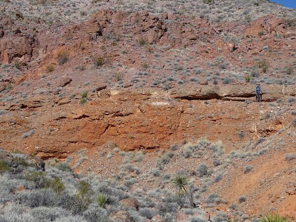
Cenozoic sedimentary rocks of Bat Mountain
Research Geologist Theresa Schwartz takes field notes about the Cenozoic sedimentary rocks of Bat Mountain (Death Valley region, California, USA).

Carbonate rocks, northern Humboldt Range, Nevada
Research Geologist Amy Gilmer walks over carbonate rocks of the Upper Triassic Star Peak Group (northern Humboldt Range, Nevada, USA).
Research Geologist Amy Gilmer walks over carbonate rocks of the Upper Triassic Star Peak Group (northern Humboldt Range, Nevada, USA).

Fluvial sandstones of the Upper Triassic Chinle Formation
Fluvial sandstones of the Upper Triassic Chinle FormationResearch Geologist A. Kate Souders samples fluvial sandstones of the Upper Triassic Chinle Formation (eastern Nevada, USA).
Fluvial sandstones of the Upper Triassic Chinle Formation
Fluvial sandstones of the Upper Triassic Chinle FormationResearch Geologist A. Kate Souders samples fluvial sandstones of the Upper Triassic Chinle Formation (eastern Nevada, USA).

Middle Cenozoic volcaniclastic rocks of the Death Valley region
Middle Cenozoic volcaniclastic rocks of the Death Valley regionResearch Geologist A. Kate Souders investigates complexly deformed, middle Cenozoic volcaniclastic rocks of the Death Valley region (California, USA).
Middle Cenozoic volcaniclastic rocks of the Death Valley region
Middle Cenozoic volcaniclastic rocks of the Death Valley regionResearch Geologist A. Kate Souders investigates complexly deformed, middle Cenozoic volcaniclastic rocks of the Death Valley region (California, USA).

Fluvial deposits of the Paleocene Raton Formation
Research Geologist Marieke Dechesne describes fluvial deposits of the Paleocene Raton Formation (Raton Basin, Colorado, USA).
Research Geologist Marieke Dechesne describes fluvial deposits of the Paleocene Raton Formation (Raton Basin, Colorado, USA).

The Great Unconformity, Colorado National Monument
The Great Unconformity, Colorado National MonumentThe moon sets over an exposure of the Great Unconformity within the Colorado National Monument (Colorado, USA). At this location, Paleoproterozoic granite (foreground) is unconformably overlain by the Upper Triassic Chinle Formation.

Gravel deposits and associated geologic hazards along the Hines Creek fault system, Denali National Park
Gravel deposits and associated geologic hazards along the Hines Creek fault system, Denali National ParkIntermountain West Project members Adam Hudson and Michael Frothingham, in collaboration with National Park Service archaeologist Patrick Fristoe, inspect gravel deposits and associated geologic hazards along the Hines Creek fault system, Denali National Park (Alaska, USA).

Collecting sediment for geochemical analysis
In an effort to better understand the effects of abandoned mine lands on natural resources, Research Geologists Margaret Berry and Adam Hudson collect samples of ancestral Animas River sediment for geochemical analysis (Durango, Colorado, USA).
In an effort to better understand the effects of abandoned mine lands on natural resources, Research Geologists Margaret Berry and Adam Hudson collect samples of ancestral Animas River sediment for geochemical analysis (Durango, Colorado, USA).

Cottonwood Pass, Colorado
A view westward from Cottonwood Pass (Sawatch Range, Colorado, USA) into the Taylor Park basin. The peaks in the backgorund are composed of igneous and metamorphic rocks ranging in age from early Paleozoic to Eocene, uplifted along the Taylor Park fault.
A view westward from Cottonwood Pass (Sawatch Range, Colorado, USA) into the Taylor Park basin. The peaks in the backgorund are composed of igneous and metamorphic rocks ranging in age from early Paleozoic to Eocene, uplifted along the Taylor Park fault.

Multi-colored lacustrine shales of the Oligocene Amargosa Valley Formation
Multi-colored lacustrine shales of the Oligocene Amargosa Valley FormationResearch Geologist Jens-Erik Lundstern explores multi-colored lacustrine shales of the Oligocene Amargosa Valley Formation (Bat Mountain, California, USA).
Cenozoic fluvial conglomerates in the Delamar Mountains, Nevada
Cenozoic fluvial conglomerates in the Delamar Mountains, NevadaResearch Geologist Jens-Erik Lundstern poses as a scale for middle Cenozoic fluvial conglomerates in the Delamar Mountains (southern Nevada, USA).
Cenozoic fluvial conglomerates in the Delamar Mountains, Nevada
Cenozoic fluvial conglomerates in the Delamar Mountains, NevadaResearch Geologist Jens-Erik Lundstern poses as a scale for middle Cenozoic fluvial conglomerates in the Delamar Mountains (southern Nevada, USA).

Geologic Framework of the Intermountain West project members
Geologic Framework of the Intermountain West project membersIntermountain West Project members pose at the summit of Crested Butte (Colorado, USA) prior to examining the Crested Butte laccolith (from left to right, Jeremy Workman, Allison Dombrowski, Ian Hillenbrand, Amy Gilmer, Kenzie Turner, and Ren Thompson).

Sediment core photography
Photography of split sediment cores is calibrated for color/light. This example is from Lake Lucille, Alaska.
Photography of split sediment cores is calibrated for color/light. This example is from Lake Lucille, Alaska.

USGS UAS pilot conducts lidar mapping flight over Ackerson Meadow in November 2023
USGS UAS pilot conducts lidar mapping flight over Ackerson Meadow in November 2023USGS UAS pilot Mark Bauer (NUSO) conducts lidar mapping flight over Ackerson Meadow in November 2023
USGS UAS pilot conducts lidar mapping flight over Ackerson Meadow in November 2023
USGS UAS pilot conducts lidar mapping flight over Ackerson Meadow in November 2023USGS UAS pilot Mark Bauer (NUSO) conducts lidar mapping flight over Ackerson Meadow in November 2023
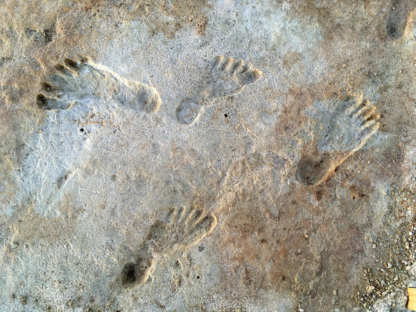
Footprints found in White Sands National Park
Footprints found in White Sands National Park were dated to the Last Glacial Maximum by USGS Research Geologists Kathleen Springer and Jeff Pigati.
Footprints found in White Sands National Park were dated to the Last Glacial Maximum by USGS Research Geologists Kathleen Springer and Jeff Pigati.
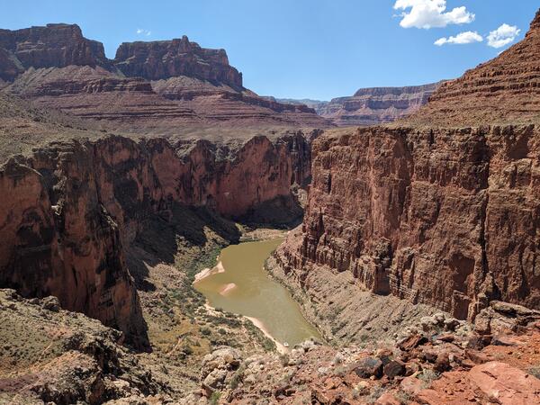
Grand_Canyon_20230908_Brennan.jpg
Photograph of the Colorado River in the Grand Canyon, Arizona, USA. Photo taken on September 8, 2023.
By
Core Science Systems Mission Area, Natural Hazards Mission Area, Water Resources Mission Area, Mineral Resources Program, National Cooperative Geologic Mapping Program, National Water Quality Program, Toxic Substances Hydrology, Geology, Geophysics, and Geochemistry Science Center, Geology, Minerals, Energy, and Geophysics Science Center, Geosciences and Environmental Change Science Center, New Mexico Water Science Center, Southwest Biological Science Center, Denver Radiogenic Isotope Lab, National Water Quality Laboratory, New Mexico Water Science Center Sediment Laboratory, Organic Geochemistry Laboratory, Geological Materials Repository, Geology and Ecology of National Parks, Colorado River Basin: Actionable and Strategic Integrated Science and Technology

Drone image captured during almond field mapping in the Central Valley of California
Drone image captured during almond field mapping in the Central Valley of CaliforniaIn August 2023, the USGS National Uncrewed Systems Office (NUSO) participated in a collaborative field campaign to collect remote sensing data over agricultural crop fields in California's Central Valley. Hyperspectral satellites were commissioned in coordination with hyperspectral UAS flights at an altitude of 300 feet above ground level.

Checking the hyperspectral sensor externally mounted to a UAS prior to flights in California
Checking the hyperspectral sensor externally mounted to a UAS prior to flights in CaliforniaMatt Burgess (NUSO) checking the hyperspectral sensor externally mounted to a UAS (held by Joe Adams NUSO) prior to flights in California

Dense point cloud generated using UAS photogrammetric techniques based on imagery acquired at the Alamosa NWR
Dense point cloud generated using UAS photogrammetric techniques based on imagery acquired at the Alamosa NWRDense point cloud generated using UAS photogrammetric techniques with natural color based on imagery acquired at the Alamosa National Wildlife Refuge (NWR) in Colorado.

USGS remote pilot at the Bonanza Creek Long-Term Ecological Research Site near Fairbanks, Alaska
USGS remote pilot at the Bonanza Creek Long-Term Ecological Research Site near Fairbanks, AlaskaUSGS remote pilot Victoria Scholl flying a UAS at the Bonanza Creek Long-Term Ecological Research Site near Fairbanks, Alaska

Boardwalk through the Bonanza Creek Long-Term Ecological Research Site near Fairbanks, Alaska
Boardwalk through the Bonanza Creek Long-Term Ecological Research Site near Fairbanks, AlaskaBoardwalk through the Bonanza Creek Long-Term Ecological Research Site near Fairbanks, Alaska
In August 2023 the NUSO flew UAS equipped with custom methane-detecting sensors over Interior Alaska to support USGS and U.S. Environmental Protection Agency (EPA) Office of Research and Development research into low-cost ways to measure methane emissions.