U.S. flag

An official website of the United States government

Images

Images intro.
Filter Total Items: 328
USGS scientist preparing a UAS mounted emissions sampler at the annual grassland burns at Konza Prairie Biological Station
USGS scientist collecting a spectral measurement in a wetland at Cape Cod, Massachusetts

USGS scientist Victoria Scholl collecting a spectral measurement in a wetland at Cape Cod, Massachusetts. The PVC pipe quadrat was placed around materials of interest (in this image, pink Salicornia vegetation) and the small panel was used as a white reference prior to spectrometer measurements.

USGS scientist Victoria Scholl collecting a spectral measurement in a wetland at Cape Cod, Massachusetts. The PVC pipe quadrat was placed around materials of interest (in this image, pink Salicornia vegetation) and the small panel was used as a white reference prior to spectrometer measurements.

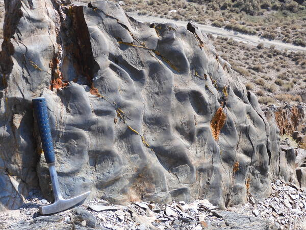
Rippling marine deposits with hammer shown for scale
Ripple bedforms in Triassic marine deposits of the northern Humboldt Range, Nevada
USGS researcher returns after collecting previously deployed UAS ground targets in the Cimarron Canyon in New Mexico

USGS researcher Victoria Scholl (NUSO) returns after collecting previously deployed scale bar and ground control point survey targets along the Paleocene Poison Canyon Formation in the Cimarron Canyon, New Mexico.

UAS ground control point survey targets deployed along the Cimarron Canyon in New Mexico

UAS ground control point survey targets deployed along the Cimarron Canyon in New Mexico

One of the ground control point survey targets deployed along the Paleocene Poison Canyon Formation in the Cimarron Canyon and used to provide accurate GPS data during the UAS data collection flights.

UAS ground control point survey targets deployed along the Cimarron Canyon in New Mexico

One of the ground control point survey targets deployed along the Paleocene Poison Canyon Formation in the Cimarron Canyon and used to provide accurate GPS data during the UAS data collection flights.

USGS scientist places a scale bar and ground control point survey target at the Cimarron Canyon in New Mexico

USGS scientist Victoria Scholl (NUSO) places a scale bar and ground control point survey target along the Paleocene Poison Canyon Formation in the Cimarron Canyon. GPS data from these targets and derived from the UAS collected imagery helps ensure high positional and geometric accuracy of georeferenced data products including 3D models.

USGS scientist Victoria Scholl (NUSO) places a scale bar and ground control point survey target along the Paleocene Poison Canyon Formation in the Cimarron Canyon. GPS data from these targets and derived from the UAS collected imagery helps ensure high positional and geometric accuracy of georeferenced data products including 3D models.

USGS remote pilot replaces UAS batteries during a mission at the Cimarron Canyon in New Mexico

USGS remote pilot Todd Burton replaces UAS batteries during a mission at the Cimarron Canyon in New Mexico. Batteries last for only around 15 minutes, therefore a minimum of six sets are typically taken into the field which allows each used set to be cooled down, recharged, and then reused in the field.

USGS remote pilot Todd Burton replaces UAS batteries during a mission at the Cimarron Canyon in New Mexico. Batteries last for only around 15 minutes, therefore a minimum of six sets are typically taken into the field which allows each used set to be cooled down, recharged, and then reused in the field.

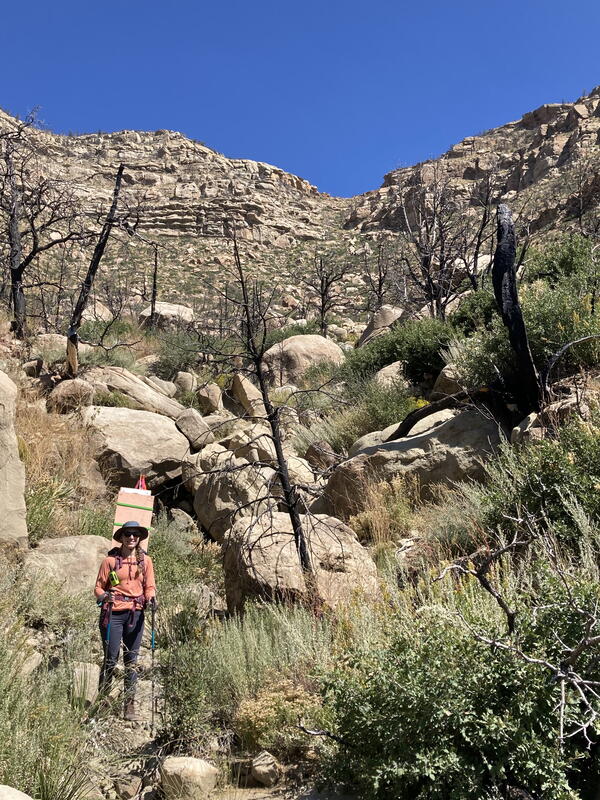
USGS researchers Amy Gilmer, Theresa Schwartz, and Victoria Scholl hike up Cimarron Canyon in New Mexico

Prior to the UAS flights USGS researchers Amy Gilmer, Theresa Schwartz, and Victoria Scholl hike up Cimarron Canyon in New Mexico to place ground control targets and scale bars.

USGS scientists hike up Cimarron Canyon in New Mexico to place UAS ground targets

Prior to the UAS flights USGS researchers Amy Gilmer, Theresa Schwartz, and Victoria Scholl hike up Cimarron Canyon in New Mexico to place ground control targets and scale bars.

USGS remote pilot flies a UAS at the Cimarron Canyon in New Mexico

USGS remote pilot Mark Bauer flies a UAS with a stabilized gimbal with vibration dampening mounted with a Sony A7r camera with a locked focus using a 14mm wide angle lens at the Cimarron Canyon in New Mexico.

USGS remote pilot Mark Bauer flies a UAS with a stabilized gimbal with vibration dampening mounted with a Sony A7r camera with a locked focus using a 14mm wide angle lens at the Cimarron Canyon in New Mexico.

USGS scientists hiking to place UAS ground control targets at the Cimarron Canyon in New Mexico

USGS scientists hiking to place UAS ground control targets at the Cimarron Canyon in New Mexico

NUSO researchers worked with USGS geologists in September 2021 to establish and test unique photogrammetric data collection techniques utilizing UAS along the Paleocene Poison Canyon Formation in the Cimarron Canyon.

USGS scientists hiking to place UAS ground control targets at the Cimarron Canyon in New Mexico

NUSO researchers worked with USGS geologists in September 2021 to establish and test unique photogrammetric data collection techniques utilizing UAS along the Paleocene Poison Canyon Formation in the Cimarron Canyon.

Along the North Santiam River at the Fishermen’s Bend Recreation Area during a UAS mission

Along the North Santiam River at the Fishermen’s Bend Recreation Area during a UAS mission

The USGS Oregon Water Science Center teamed up with the NUSO in August 2021 to explore bathymetric and remote sensing techniques to detect periphyton, a complex mixture of algae, cyanobacteria, and microbes in freshwater ecosystems. 

Along the North Santiam River at the Fishermen’s Bend Recreation Area during a UAS mission

The USGS Oregon Water Science Center teamed up with the NUSO in August 2021 to explore bathymetric and remote sensing techniques to detect periphyton, a complex mixture of algae, cyanobacteria, and microbes in freshwater ecosystems. 

Image taken from a UAS showing a ground control target at the Fishermen’s Bend Recreation Area in Mill City, Oregon

Image taken from a UAS showing a ground control target at the Fishermen’s Bend Recreation Area in Mill City, Oregon

The USGS Oregon Water Science Center teamed up with the NUSO in August 2021 to explore bathymetric and remote sensing techniques to detect periphyton, a complex mixture of algae, cyanobacteria, and microbes in freshwater ecosystems. 

Image taken from a UAS showing a ground control target at the Fishermen’s Bend Recreation Area in Mill City, Oregon

The USGS Oregon Water Science Center teamed up with the NUSO in August 2021 to explore bathymetric and remote sensing techniques to detect periphyton, a complex mixture of algae, cyanobacteria, and microbes in freshwater ecosystems. 

USGS scientist collecting ground data during a UAS mission along the North Santiam River

USGS scientist Victoria Scholl collecting ground data during a UAS mission along the North Santiam River

The USGS Oregon Water Science Center teamed up with the NUSO in August 2021 to explore bathymetric and remote sensing techniques to detect periphyton, a complex mixture of algae, cyanobacteria, and microbes in freshwater ecosystems. 

USGS scientist Victoria Scholl collecting ground data during a UAS mission along the North Santiam River

The USGS Oregon Water Science Center teamed up with the NUSO in August 2021 to explore bathymetric and remote sensing techniques to detect periphyton, a complex mixture of algae, cyanobacteria, and microbes in freshwater ecosystems. 

Photograph taken from the ground showing the placement of a UAS ground control target at the North Santiam River

Photograph taken from the ground showing the placement of a UAS ground control target at the North Santiam River

The USGS Oregon Water Science Center teamed up with the NUSO in August 2021 to explore bathymetric and remote sensing techniques to detect periphyton, a complex mixture of algae, cyanobacteria, and microbes in freshwater ecosystems. 

Photograph taken from the ground showing the placement of a UAS ground control target at the North Santiam River

The USGS Oregon Water Science Center teamed up with the NUSO in August 2021 to explore bathymetric and remote sensing techniques to detect periphyton, a complex mixture of algae, cyanobacteria, and microbes in freshwater ecosystems. 

Example of the Landsat Collection 2 Burned Area Science Product
Example of the Landsat Collection 2 Burned Area Science Product showing the Bootleg Fire in Oregon

Example of the Landsat Collection 2 Burned Area Science Product showing the Bootleg Fire in Oregon on July 11, 2021 for tile h006V010. Left: Landsat 8 Collection 2 U.S. Analysis Ready Data Surface Reflectance image (Bands 6,5,4), Middle: Burn Classification (BC), and Right: Burn Probability (BP).

UAS collecting lidar over an East Troublesome Fire burn scar

In June 2021, eight months after the East Troublesome Fire burned over 193,000 acres in Colorado, NUSO performed UAS data collection over several of the burn scars representing different fire intensity levels and fuel types.

In June 2021, eight months after the East Troublesome Fire burned over 193,000 acres in Colorado, NUSO performed UAS data collection over several of the burn scars representing different fire intensity levels and fuel types.

Was this page helpful?