Plane light optical microscope image of a monazite grain with a 15 µm laser crater
Plane light optical microscope image of a monazite grain with a 15 µm laser craterPlane light optical microscope image of a monazite grain with a 15 µm laser crater

Official websites use .gov
A .gov website belongs to an official government organization in the United States.
Secure .gov websites use HTTPS
A lock () or https:// means you’ve safely connected to the .gov website. Share sensitive information only on official, secure websites.
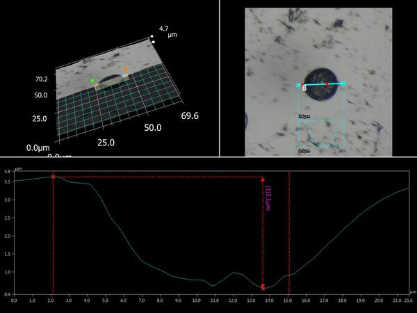
Plane light optical microscope image of a monazite grain with a 15 µm laser crater
Plane light optical microscope image of a monazite grain with a 15 µm laser crater
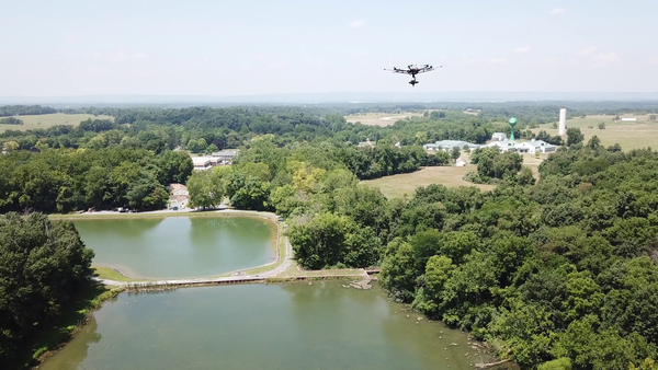
Uncrewed aircraft system (UAS) hyperspectral data collection flight over a reservoir at the Eastern USGS Eastern Ecological Science Center - Leetown Research Laboratory (EESC-LRL) in West Virginia.
Uncrewed aircraft system (UAS) hyperspectral data collection flight over a reservoir at the Eastern USGS Eastern Ecological Science Center - Leetown Research Laboratory (EESC-LRL) in West Virginia.

USGS researcher Joe Adams tacking down a calibration tarp at the Eastern Ecological Science Center - Leetown Research Laboratory.
USGS researcher Joe Adams tacking down a calibration tarp at the Eastern Ecological Science Center - Leetown Research Laboratory.
High altitude lakes provide opportunities to examine interactions between fires, drought and human activity across decadal to millennial timescales. The locations of these lakes near tree line make them more susceptible to climate-related changes in vegetation and associated biomass burning.
High altitude lakes provide opportunities to examine interactions between fires, drought and human activity across decadal to millennial timescales. The locations of these lakes near tree line make them more susceptible to climate-related changes in vegetation and associated biomass burning.
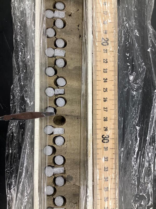
: A 25-cm section of a lake sediment core with continuous volumetric samples removed (1 cm3). The remaining cavities are filled with closed cell to preserve the core structures for future work.
: A 25-cm section of a lake sediment core with continuous volumetric samples removed (1 cm3). The remaining cavities are filled with closed cell to preserve the core structures for future work.

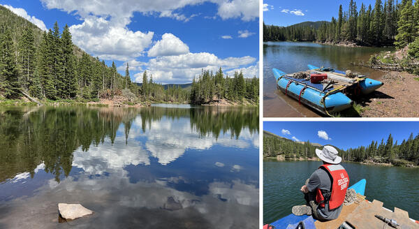
Bear Lake, Colorado is a high alpine lake near tree line that is affected by regional to local fires and vegetation changes.
Bear Lake, Colorado is a high alpine lake near tree line that is affected by regional to local fires and vegetation changes.
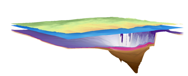
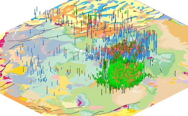
View of the Anadarko sedimentary basin from above, looking to the northeast. Colored surfaces represent the top of specific geologic units as mapped in the subsurface.
View of the Anadarko sedimentary basin from above, looking to the northeast. Colored surfaces represent the top of specific geologic units as mapped in the subsurface.

USGS remote pilots Joe Adams and Matt Burgess each flying a UAS mounted with a hyperspectral sensor over ponds at the USGS Eastern Ecological Science Center - Leetown Research Laboratory (EESC-LRL)
USGS remote pilots Joe Adams and Matt Burgess each flying a UAS mounted with a hyperspectral sensor over ponds at the USGS Eastern Ecological Science Center - Leetown Research Laboratory (EESC-LRL)
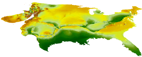
Perspective view of the Continental U.S. showing an elevation surface of the top of crystalline Precambrian “basement” rocks. Brown and orange colors depict the highest elevations; greens show the lowest elevations. Surface is incomplete in the western U.S. where there are no published “basement” maps or where crystalline Precambrian rocks are not present.
Perspective view of the Continental U.S. showing an elevation surface of the top of crystalline Precambrian “basement” rocks. Brown and orange colors depict the highest elevations; greens show the lowest elevations. Surface is incomplete in the western U.S. where there are no published “basement” maps or where crystalline Precambrian rocks are not present.
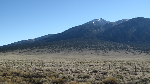
Photograph of Blanca Peak (Colorado) looking up at an alluvial fan and glacial moraine sourced from an alpine catchment. Deposits like these are often important records of past changes in erosion, sedimentation, and tectonic activity.
Photograph of Blanca Peak (Colorado) looking up at an alluvial fan and glacial moraine sourced from an alpine catchment. Deposits like these are often important records of past changes in erosion, sedimentation, and tectonic activity.
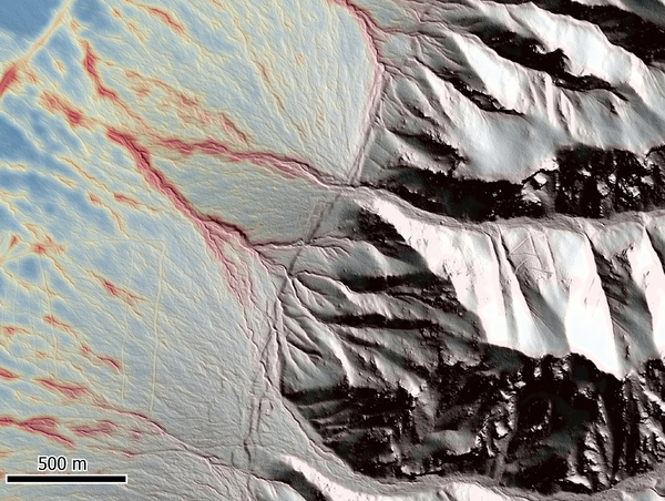
This image depicts a Quaternary fault scarp running vertically across the center of the image, separating active sedimentation on the left from eroding mountain catchments on the right.
This image depicts a Quaternary fault scarp running vertically across the center of the image, separating active sedimentation on the left from eroding mountain catchments on the right.
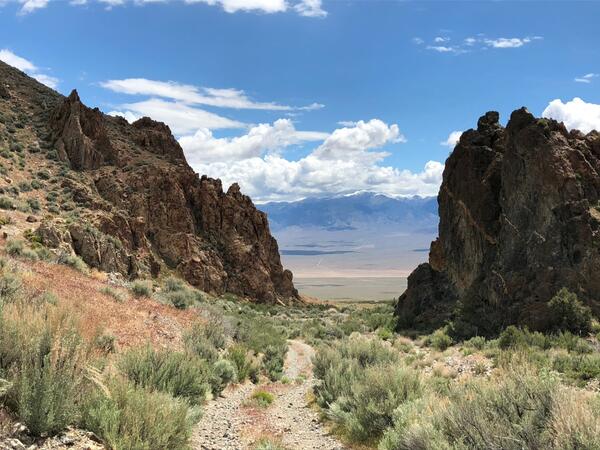
View east across Dixie Valley from the crest of the Stillwater Range, western Nevada. In the foreground are igneous rocks of an Oligocene caldera complex; bedrock in the Desatoya Mountains on the horizon is a slightly younger caldera complex. A major challenge for bedrock mapping is inferring what is in the subsurface between exposures like these.
View east across Dixie Valley from the crest of the Stillwater Range, western Nevada. In the foreground are igneous rocks of an Oligocene caldera complex; bedrock in the Desatoya Mountains on the horizon is a slightly younger caldera complex. A major challenge for bedrock mapping is inferring what is in the subsurface between exposures like these.
Perspective view of the Colorado Plateau looking from above to the northwest. Image shows a part J.C.
Perspective view of the Colorado Plateau looking from above to the northwest. Image shows a part J.C.
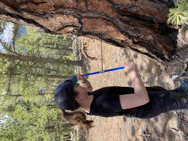
USGS Geologist Natalie Kehrwald takes a tree ring sample. Tree rings can provide sub-seasonal records of hydroclimate and fire over centennial time scales.
USGS Geologist Natalie Kehrwald takes a tree ring sample. Tree rings can provide sub-seasonal records of hydroclimate and fire over centennial time scales.
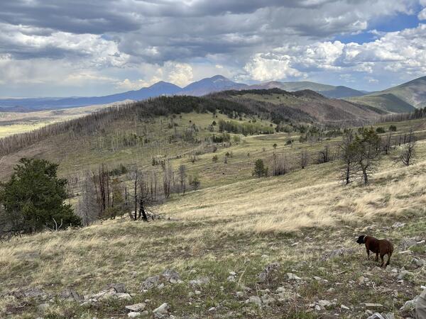
Landscape-scale fire and wind damage to tree stands on the Trinchera Ranch, Colorado
Landscape-scale fire and wind damage to tree stands on the Trinchera Ranch, Colorado

Closeup of a tree core sample showing tree rings obtained using increment borer, Dinosaur National Monument.
Closeup of a tree core sample showing tree rings obtained using increment borer, Dinosaur National Monument.

USGS researcher Matt Burgess remotely pilots a UAS collecting lidar data during the April 2022 USGS UASnow project at Berthoud Pass, Colorado.
USGS researcher Matt Burgess remotely pilots a UAS collecting lidar data during the April 2022 USGS UASnow project at Berthoud Pass, Colorado.
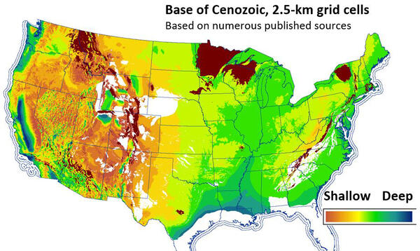
Map view of the Continental U.S. showing a national-scale elevation surface of the base of Cenozoic rocks. Dark brown irregular polygons are outcrops of Precambrian rocks.
Map view of the Continental U.S. showing a national-scale elevation surface of the base of Cenozoic rocks. Dark brown irregular polygons are outcrops of Precambrian rocks.

One productive coring trip provides >50-m of sediment for analyses and curation. The Quaternary Lab currently stores ~350-m of soft sediment cores collected between 2005 and 2025.
One productive coring trip provides >50-m of sediment for analyses and curation. The Quaternary Lab currently stores ~350-m of soft sediment cores collected between 2005 and 2025.

USGS researcher Joe Adams in front of a UAS ground control target at a burned site within the Lake–Napa Unit (LNU) Lightning Complex fire area.
USGS researcher Joe Adams in front of a UAS ground control target at a burned site within the Lake–Napa Unit (LNU) Lightning Complex fire area.

Manual piston coring is used for lakes <20-m water depth and can obtain up to 15-20m sediment core.
Manual piston coring is used for lakes <20-m water depth and can obtain up to 15-20m sediment core.