
USGS scientists drilling Santa Fe Lake, New Mexico as part of fieldwork conducted with the Did we start the fire? Climate, Fire and Humans project.
Images
Images intro.
Filter Total Items: 316

Coring in Santa Fe Lake, New Mexico
USGS scientists drilling Santa Fe Lake, New Mexico as part of fieldwork conducted with the Did we start the fire? Climate, Fire and Humans project.

Three-dimensional (3D) geologic framework model of the Rio San Jose groundwater basin, New Mexico: U.S. Geological Survey data release, https://doi.org/10.5066/P9MPAGA7
Three-dimensional (3D) geologic framework model of the Rio San Jose groundwater basin, New Mexico: U.S. Geological Survey data release, https://doi.org/10.5066/P9MPAGA73D geologic framework model from west-central New Mexico; graphic shows stratigraphic units in the model being sequentially removed to reveal the deeper units. Faults used in the model appear as vertical “ribbons” as geologic layers are removed.
Three-dimensional (3D) geologic framework model of the Rio San Jose groundwater basin, New Mexico: U.S. Geological Survey data release, https://doi.org/10.5066/P9MPAGA7
Three-dimensional (3D) geologic framework model of the Rio San Jose groundwater basin, New Mexico: U.S. Geological Survey data release, https://doi.org/10.5066/P9MPAGA7Three-dimensional (3D) geologic framework model of the Rio San Jose groundwater basin, New Mexico: U.S. Geological Survey data release, https://doi.org/10.5066/P9MPAGA7
Three-dimensional (3D) geologic framework model of the Rio San Jose groundwater basin, New Mexico: U.S. Geological Survey data release, https://doi.org/10.5066/P9MPAGA73D geologic framework model from west-central New Mexico; graphic shows stratigraphic units in the model being sequentially removed to reveal the deeper units. Faults used in the model appear as vertical “ribbons” as geologic layers are removed.

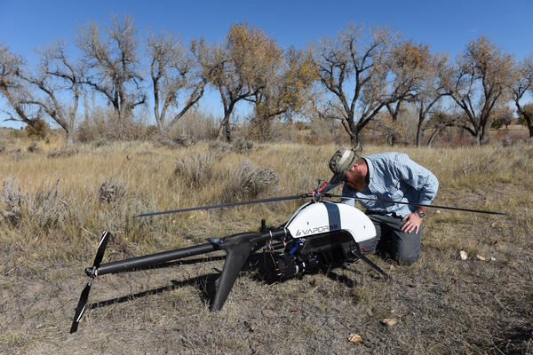
USGS scientists preparing a UAS mounted with a lidar sensor for flight at Denver Colorado’s City Park
USGS scientists preparing a UAS mounted with a lidar sensor for flight at Denver Colorado’s City ParkUSGS scientists Mark Bauer and Matt Burgess preparing a UAS mounted with a lidar sensor for flight at Denver Colorado’s City Park
During the summer of 2019 NUSO researchers evaluated the viability of using UAS platforms and data collection sensors to characterize and evaluate an urban forest.
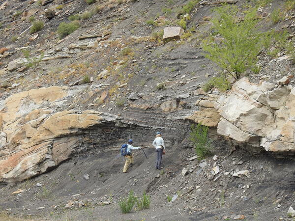
Paleocene fluvial deposits in the Raton Basin, Colorado
Paleocene fluvial deposits in the Raton Basin, ColoradoThe stratigraphic architecture of fluvial deposits reveals changes in river behavior associated with active tectonism and climatic change.
Paleocene fluvial deposits in the Raton Basin, Colorado
Paleocene fluvial deposits in the Raton Basin, ColoradoThe stratigraphic architecture of fluvial deposits reveals changes in river behavior associated with active tectonism and climatic change.

USGS scientist flying a UAS at the Puʻuhonua o Hōnaunau National Historical Park
USGS scientist flying a UAS at the Puʻuhonua o Hōnaunau National Historical ParkUSGS scientist Todd Burton flying a UAS at the Puʻuhonua o Hōnaunau National Historical Park
USGS scientist flying a UAS at the Puʻuhonua o Hōnaunau National Historical Park
USGS scientist flying a UAS at the Puʻuhonua o Hōnaunau National Historical ParkUSGS scientist Todd Burton flying a UAS at the Puʻuhonua o Hōnaunau National Historical Park
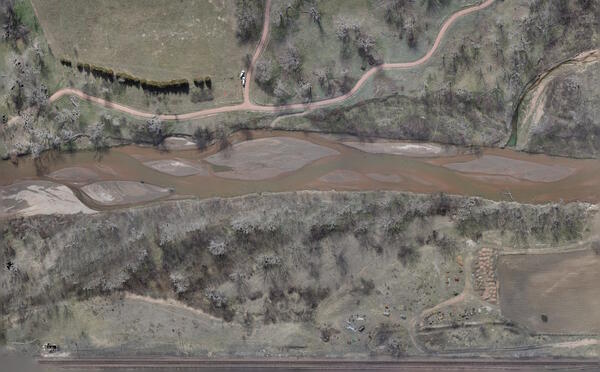
Image of Fountain Creek taken from a natural color sensor mounted on a UAS
Image of Fountain Creek taken from a natural color sensor mounted on a UASImage of Fountain Creek taken from a natural color sensor mounted on a UAS
In April 2019 the NUSO completed a study to compare UAS collected data versus traditionally manually collected data for supporting geomorphic surface monitoring. Previous data collection efforts having taken place in February 2016, and January and March of 2017.

Image of the 2018 Eruption of the Kilauea Volcano taken from a UAS at night
Image of the 2018 Eruption of the Kilauea Volcano taken from a UAS at nightImage of the 2018 Eruption of the Kilauea Volcano taken from a UAS at night
Image of the 2018 Eruption of the Kilauea Volcano taken from a UAS at night
Image of the 2018 Eruption of the Kilauea Volcano taken from a UAS at nightImage of the 2018 Eruption of the Kilauea Volcano taken from a UAS at night

UAS ground control station at the 2018 eruption of the Kilauea Volcano
UAS ground control station at the 2018 eruption of the Kilauea VolcanoUAS ground control station at the 2018 eruption of the Kilauea Volcano
UAS ground control station at the 2018 eruption of the Kilauea Volcano
UAS ground control station at the 2018 eruption of the Kilauea VolcanoUAS ground control station at the 2018 eruption of the Kilauea Volcano

USGS researchers flying a UAS at the 2018 eruption of the Kilauea Volcano
USGS researchers flying a UAS at the 2018 eruption of the Kilauea VolcanoUSGS researchers Todd Burton and Joe Adams flying a UAS at the 2018 eruption of the Kilauea Volcano
USGS researchers flying a UAS at the 2018 eruption of the Kilauea Volcano
USGS researchers flying a UAS at the 2018 eruption of the Kilauea VolcanoUSGS researchers Todd Burton and Joe Adams flying a UAS at the 2018 eruption of the Kilauea Volcano

Animation created in EarthVision 3D Viewer using USGS data
Animation created in EarthVision 3D Viewer using USGS dataThe movie previews a 3-D hydrogeologic model of the Rio Rico and Nogales 7.5’quadrangles Arizona, included in USGS Scientific Investigations Report 2018-5062 (Page and others, 2018). The model was built in EarthVision (Dynamic Graphics, Inc.) 3D modeling software.

Petrified Forest National Park in Arizona
Petrified Forest National Park in Arizona
The NUSO, at the request of the National Park Service (NPS), collected high-resolution UAS data over five archeological sites within the park in October of 2018 and then produced highly accurate, high resolution 3D point clouds, orthomosaics, and digital elevation models for each site.

Fixed-wing UAS used to map landscape at Corral Bluffs, Colorado
Fixed-wing UAS used to map landscape at Corral Bluffs, ColoradoA FireFLY6 Pro vertical takeoff and landing (VTOL) fixed-wing UAS sits on the ground between flights at the Corral Bluffs study area to support fossil studies by the Denver Museum of Nature & Science.

USGS researchers at a UAS launch site at Colorado’s Dinosaur Ridge
USGS researchers at a UAS launch site at Colorado’s Dinosaur RidgeUSGS researchers Joe Adams and Mark Bauer at a UAS launch site at Colorado’s Dinosaur Ridge
Jefferson County Open Space and the Friends of Dinosaur Ridge collaborated with the NUSO in September 2018 to collect high-resolution UAS data for use in constructing 3D photogrammetric terrain models of potential landslide areas.

Image of Corral Bluffs taken from a natural color sensor mounted on a fixed wing UAS
Image of Corral Bluffs taken from a natural color sensor mounted on a fixed wing UASImage of Corral Bluffs taken from a natural color sensor mounted on a fixed wing UAS
Image of Corral Bluffs taken from a natural color sensor mounted on a fixed wing UAS
Image of Corral Bluffs taken from a natural color sensor mounted on a fixed wing UASImage of Corral Bluffs taken from a natural color sensor mounted on a fixed wing UAS

USGS scientists placing a UAS ground control target at Corral Bluffs
USGS scientists placing a UAS ground control target at Corral BluffsUSGS scientists placing a UAS ground control target at Corral Bluffs
USGS scientists placing a UAS ground control target at Corral Bluffs
USGS scientists placing a UAS ground control target at Corral BluffsUSGS scientists placing a UAS ground control target at Corral Bluffs

Image of the confluence of the Blue and Colorado Rivers taken from a UAS
Image of the confluence of the Blue and Colorado Rivers taken from a UASImage of the confluence of the Blue and Colorado Rivers taken from a UAS
USGS hydrologists, with help from the NUSO, planned to evaluate the value of UAS data collected over the confluence of the Blue and Colorado rivers in August 2018 for river discharge calculations and velocity rate evaluation.

Image of the 2018 eruption of the Kilauea volcano taken from a natural color sensor mounted on a UAS
Image of the 2018 eruption of the Kilauea volcano taken from a natural color sensor mounted on a UASImage of the 2018 eruption of the Kilauea volcano taken from a Sony RX1R II natural color sensor mounted on a UAS
Leaf On natural color image at the Colorado State Arboretum taken from a UAS
Leaf On natural color image at the Colorado State Arboretum taken from a UASLeaf On natural color image at the Colorado State Arboretum taken from a UAS
Leaf On natural color image at the Colorado State Arboretum taken from a UAS
Leaf On natural color image at the Colorado State Arboretum taken from a UASLeaf On natural color image at the Colorado State Arboretum taken from a UAS
USGS researcher prepares a UAS with a mounted lidar sensor
USGS researcher prepares a UAS with a mounted lidar sensorUSGS researcher Todd Burton prepares a UAS with a mounted lidar sensor
At the request of the National Park Service in October 2017 the NUSO utilized UAS to acquire geospatial data to support development of a flood management plan for the Fort Laramie National Historic Site in Wyoming.
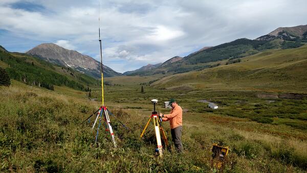
USGS scientist using RTK to establish ground control for a UAS mission
USGS scientist using RTK to establish ground control for a UAS missionUSGS scientist using RTK to establish ground control for a UAS mission
USGS scientist using RTK to establish ground control for a UAS mission
USGS scientist using RTK to establish ground control for a UAS missionUSGS scientist using RTK to establish ground control for a UAS mission
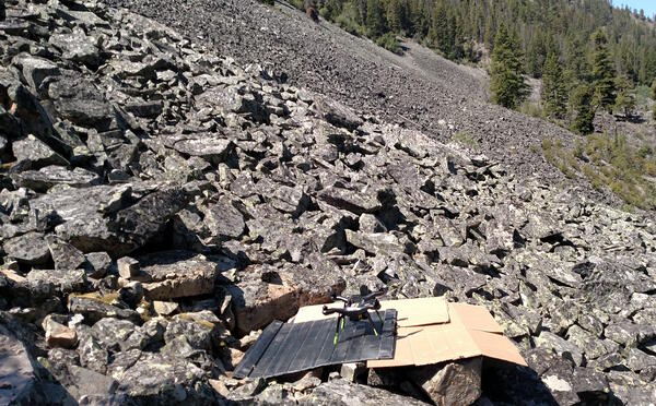
UAS launch site at Talus slopes in the Bitterroot National Forest
UAS launch site at Talus slopes in the Bitterroot National ForestUAS launch site at Talus slopes in the Bitterroot National Forest
The Northern Rocky Mountain Science Center, with help from the NUSO in July 2017, evaluated the use of UAS in high elevation areas of Montana over Talus slopes to collect the thermal imagery needed to map unique habitats for montane species.