
New England WSC Physical Scientist Andy Massey scouting out high water marks associated with the blizzard of January 2018. Houghs Neck Maritime Center, Quincy, MA.
Images
Click through our gallery of photographs showcasing New England Water Science Center research projects and monitoring work throughout the region.
Filter Total Items: 601

Scouting out high water marks after blizzard
New England WSC Physical Scientist Andy Massey scouting out high water marks associated with the blizzard of January 2018. Houghs Neck Maritime Center, Quincy, MA.
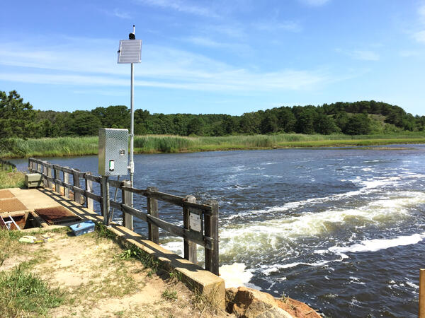
Upstream side of USGS station, Herring River at Chequessett Neck Road Dike, Wellfleet, Massachusetts
Upstream side of USGS station, Herring River at Chequessett Neck Road Dike, Wellfleet, MassachusettsUpstream side of USGS Station 011058798, Herring River at Chequessett Neck Road Dike, Wellfleet, Massachusetts.

Surveying for the FEMA project
Sam Banas using a total station to survey points on the covered bridge that is located along the Tioga River in the Belmont, New Hampshire. These survey points will be used in the Winnipesaukee Watershed flood risk analysis mapping project funded by FEMA as part of the National Flood Insurance Program.
Sam Banas using a total station to survey points on the covered bridge that is located along the Tioga River in the Belmont, New Hampshire. These survey points will be used in the Winnipesaukee Watershed flood risk analysis mapping project funded by FEMA as part of the National Flood Insurance Program.

USGS Station 011058798 Herring River at Chequessett Neck Rd gage house
USGS Station 011058798 Herring River at Chequessett Neck Rd gage houseThis is a downstream view of the Herring River from the Chequessett Neck Road dike. The site was visited on November 6, 2017 to collect water-quality samples. An automated sampler inside the gage house was used to collect samples over an approximately 24-hour period and combine them into two bottles.

Leaf litter removal practices
Leaf litter removal practices in Vermont
Leaf litter removal practices in Vermont

Fixed-site monitoring station in Mount Hope Bay
Massachusetts Department of Environmental Protection Taunton River fixed-site monitoring station (B11), collecting continuous water-quality data in Mt Hope Bay near Somerset, MA. In the background are the former Brayton Point Power Plant cooling towers, demolished on April 27, 2019.
Massachusetts Department of Environmental Protection Taunton River fixed-site monitoring station (B11), collecting continuous water-quality data in Mt Hope Bay near Somerset, MA. In the background are the former Brayton Point Power Plant cooling towers, demolished on April 27, 2019.

City of Fall River, Massachusetts
View of the City of Fall River, Massachusetts and Mount Hope Bay - a tidal estuary located at the mouth of the Taunton River on the Massachusetts and Rhode Island border.
View of the City of Fall River, Massachusetts and Mount Hope Bay - a tidal estuary located at the mouth of the Taunton River on the Massachusetts and Rhode Island border.
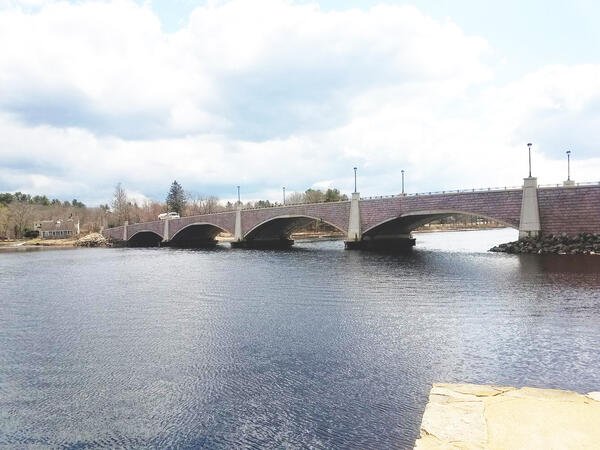
Berkley Bridge over the Taunton River in Massachusetts
Berkley Bridge over the Taunton River in MassachusettsA view of the Berkley-Dighton Bridge that cross over the Taunton River in Massachusetts. USGS and the Massachusetts Department of Environmental Protection collects water quality data in the Taunton River.

"Miss Q" Ready to Go
The Maine Office boat, "Miss Q", is parked next to the boat launch on Verona Island, ready to begin data collection on the Penobscot River. The crew was preparing to collect ADCP data (depth and velocity) as well as conductivity, temperature and depth profiles at various locations. In the background is the Penobscot Narrows Bridge and Fort Knox.
The Maine Office boat, "Miss Q", is parked next to the boat launch on Verona Island, ready to begin data collection on the Penobscot River. The crew was preparing to collect ADCP data (depth and velocity) as well as conductivity, temperature and depth profiles at various locations. In the background is the Penobscot Narrows Bridge and Fort Knox.

01174565 streamgage station, West Branch Swift River, Shutesbury, MA
01174565 streamgage station, West Branch Swift River, Shutesbury, MAUSGS 01174565 gaging station, West Branch Swift River near Shutesbury, Massachusetts
01174565 streamgage station, West Branch Swift River, Shutesbury, MA
01174565 streamgage station, West Branch Swift River, Shutesbury, MAUSGS 01174565 gaging station, West Branch Swift River near Shutesbury, Massachusetts

Streamflow measurement - Charles River Wellesley, MA
Streamflow measurement - Charles River Wellesley, MAStreamflow measurement near the Charles River USGS 01104200 gage at Wellesley, MA
Streamflow measurement - Charles River Wellesley, MA
Streamflow measurement - Charles River Wellesley, MAStreamflow measurement near the Charles River USGS 01104200 gage at Wellesley, MA

USGS employee conducts gage inspection at gage 1175500 Swift River MA
USGS employee conducts gage inspection at gage 1175500 Swift River MAUSGS employee conducts gage inspection at the 1175500 Swift River, MA gage location.
USGS employee conducts gage inspection at gage 1175500 Swift River MA
USGS employee conducts gage inspection at gage 1175500 Swift River MAUSGS employee conducts gage inspection at the 1175500 Swift River, MA gage location.

USGS Streamgage 1174500 East Branch Swift River Near Hardwick, MA

Continuous water-quality monitor
Photograph showing a continuous water-quality monitor at the Salmon River near East Hampton, Connecticut.
Photograph showing a continuous water-quality monitor at the Salmon River near East Hampton, Connecticut.

011058798 Herring River at Chequessett Neck Rd gage house
011058798 Herring River at Chequessett Neck Rd gage houseUSGS Station 011058798 Herring River at Chequessett Neck Rd gage house and the downstream view of the Herring River from the Chequessett Neck Road dike.
011058798 Herring River at Chequessett Neck Rd gage house
011058798 Herring River at Chequessett Neck Rd gage houseUSGS Station 011058798 Herring River at Chequessett Neck Rd gage house and the downstream view of the Herring River from the Chequessett Neck Road dike.

Low-Flow Sampling of Groundwater at Stringfellow Superfund Site in California
Low-Flow Sampling of Groundwater at Stringfellow Superfund Site in CaliforniaLow-flow groundwater sampling data was collected at the Stringfellow Superfund Site in California. This data was used to assess how well the Purge Analyzer Tool simulates in-well groundwater flow.

Squam River Covered Bridge
Covered Bridge spanning the Squam River as it flows from the Little Squam Lake in Ashland, New Hampshire.
Covered Bridge spanning the Squam River as it flows from the Little Squam Lake in Ashland, New Hampshire.

Highflow measurement downstream of a dam
High flow measurements are important is refining and confirming the validity of the high end of discharge ratings. Here, a technician moves the manned boat back and forth across the river channel with an ADCP tethered to the side of the boat.
High flow measurements are important is refining and confirming the validity of the high end of discharge ratings. Here, a technician moves the manned boat back and forth across the river channel with an ADCP tethered to the side of the boat.

Monitoring wells East Falmouth, MA
Monitoring wells located along the eastern shore of Little Pond, East Falmouth, Massachusetts.
Monitoring wells located along the eastern shore of Little Pond, East Falmouth, Massachusetts.

Scientist inserting a snow tube
Physical Scientist Serena Matt inserting a fiberglass snow tube during the Snow Depth and Snow Water Equivalent (SWE) measurement. Sleepers River Research Watershed, Danville, Vermont.
Physical Scientist Serena Matt inserting a fiberglass snow tube during the Snow Depth and Snow Water Equivalent (SWE) measurement. Sleepers River Research Watershed, Danville, Vermont.

Scientist posing next to a snow scale
Physical Scientist Serena Matt posing next to a snow scale during the Snow Depth and Snow Water Equivalent (SWE) measurement. Sleepers River Research Watershed, Danville, Vermont.
Physical Scientist Serena Matt posing next to a snow scale during the Snow Depth and Snow Water Equivalent (SWE) measurement. Sleepers River Research Watershed, Danville, Vermont.