
Bunnell Brook in Connecticut with leaves on the banks. The photo taken from the center of the channel.
Images
Click through our gallery of photographs showcasing New England Water Science Center research projects and monitoring work throughout the region.
Filter Total Items: 601

Stream with leaves on the banks
Bunnell Brook in Connecticut with leaves on the banks. The photo taken from the center of the channel.

Streamgage in Connecticut
A beautiful capture of a streamgage at Bunnell Brook near Burlington, CT.

Autumn in New England
Long exposure photo of a river during fall as the leaves are beginning to turn colors.
Long exposure photo of a river during fall as the leaves are beginning to turn colors.

Streamflow measurement in the fall
Hydro Technician, Henry Witt, takes a self portrait while he conducts a discharge measurement in the Houstonic River at Falls Village, CT. One of the many perks of field work year round is the ability to witness the seasons come and go.
Hydro Technician, Henry Witt, takes a self portrait while he conducts a discharge measurement in the Houstonic River at Falls Village, CT. One of the many perks of field work year round is the ability to witness the seasons come and go.

Shepaug River Peter's Dam gage pool
Autumnal reflection in the Shepaug River Peter's Dam gage pool looking upstream at the dam with the gage in view (site 01202501 at Woodville, CT). The blue sky and Autumn leaves cast a reflection in the gage pool.
Autumnal reflection in the Shepaug River Peter's Dam gage pool looking upstream at the dam with the gage in view (site 01202501 at Woodville, CT). The blue sky and Autumn leaves cast a reflection in the gage pool.

Different Types of Iron Staining on Downhole Samplers
Different Types of Iron Staining on Downhole SamplersUSGS Research Hydrologist Philip Harte describes the different types of different iron staining visible on downhole samplers that were used in passive sampling of groundwater wells.
Different Types of Iron Staining on Downhole Samplers
Different Types of Iron Staining on Downhole SamplersUSGS Research Hydrologist Philip Harte describes the different types of different iron staining visible on downhole samplers that were used in passive sampling of groundwater wells.

Measuring Water-Levels in a Monitoring Well at Homestake Mining Company Superfund Site
Measuring Water-Levels in a Monitoring Well at Homestake Mining Company Superfund SiteResearch Hydrologist Phil Harte takes water-level measurements from a monitoring well that is adjacent to a uranium waste pile (visible in the background of the photograph).

Habitat assessment in the Bronx River NY
Peter VanMetre and Jennifer Krstolic making a habitat assessment in the Bronx River, NY as a part of the 2016 USGS National Water-Quality Assessment (NAWQA) stream quality assessment in the northeastern United States.
Peter VanMetre and Jennifer Krstolic making a habitat assessment in the Bronx River, NY as a part of the 2016 USGS National Water-Quality Assessment (NAWQA) stream quality assessment in the northeastern United States.

Groundwater sampling
Groundwater sampling along the eastern shore of Little Pond, East Falmouth, Massachusetts.
Groundwater sampling along the eastern shore of Little Pond, East Falmouth, Massachusetts.

Groundwater sampling
Groundwater sampling along the western shore of Great Pond, East Falmouth, Massachusetts.
Groundwater sampling along the western shore of Great Pond, East Falmouth, Massachusetts.

Joseph Levitt secures the new buoy off Weirs Beach, NH
Joseph Levitt secures the new buoy off Weirs Beach, NHUSGS scientist Joseph Levitt secured the new buoy, equipped to monitor water quality, at Weirs Beach on Lake Winnepesaukee, New Hampshire in June 2016. Photo: Sanborn Ward, USGS
Joseph Levitt secures the new buoy off Weirs Beach, NH
Joseph Levitt secures the new buoy off Weirs Beach, NHUSGS scientist Joseph Levitt secured the new buoy, equipped to monitor water quality, at Weirs Beach on Lake Winnepesaukee, New Hampshire in June 2016. Photo: Sanborn Ward, USGS

A new buoy for Lake Winnipesaukee
In June, USGS scientists deployed a new high tech buoy that will help determine when the water is safe for swimming at popular Weirs Beach on New Hampshire's Lake Winnepesaukee. Photo: Richard Kiah, USGS.
In June, USGS scientists deployed a new high tech buoy that will help determine when the water is safe for swimming at popular Weirs Beach on New Hampshire's Lake Winnepesaukee. Photo: Richard Kiah, USGS.

Mount Tom, Holyoke, MA
Mount Tom Range and is located in the Connecticut River Valley region of Massachusetts, north of the city of Springfield. Mount Tom features wonderful views of the Pioneer Valley in west-central Massachusetts.
Mount Tom Range and is located in the Connecticut River Valley region of Massachusetts, north of the city of Springfield. Mount Tom features wonderful views of the Pioneer Valley in west-central Massachusetts.

View along the eastern shore of Little Pond, East Falmouth
View along the eastern shore of Little Pond, East FalmouthEutrophication is seen along the eastern shore of Little Pond, East Falmouth, Massachusetts.
View along the eastern shore of Little Pond, East Falmouth
View along the eastern shore of Little Pond, East FalmouthEutrophication is seen along the eastern shore of Little Pond, East Falmouth, Massachusetts.

View of the eastern shore of Little Pond, East Falmouth, MA
View of the eastern shore of Little Pond, East Falmouth, MAEutrophication seen on the eastern shore of Little Pond, East Falmouth, Massachusetts.
View of the eastern shore of Little Pond, East Falmouth, MA
View of the eastern shore of Little Pond, East Falmouth, MAEutrophication seen on the eastern shore of Little Pond, East Falmouth, Massachusetts.

Well installation using a Geoprobe drilling rig
Well installation using a Geoprobe drilling rig in the Maravista neighborhood, East Falmouth, MA
Well installation using a Geoprobe drilling rig in the Maravista neighborhood, East Falmouth, MA

Glacial potholes
Glacial potholes of the Deerfield River in Shelburne Falls, a historic village in the towns of Shelburne and Buckland in Franklin County, Massachusetts,
Glacial potholes of the Deerfield River in Shelburne Falls, a historic village in the towns of Shelburne and Buckland in Franklin County, Massachusetts,

Installation of a sealed domestic well cap
Photo showing the installation of a sealed domestic well cap and instruments to continuously monitor water level and physiochemical parameters (pH, dissolved oxygen, specific conductance, and temperature). The USGS monitors the quality of groundwater across the country.
Photo showing the installation of a sealed domestic well cap and instruments to continuously monitor water level and physiochemical parameters (pH, dissolved oxygen, specific conductance, and temperature). The USGS monitors the quality of groundwater across the country.

Winter landscape at Bunnell Brook, Burlington, CT
Northeast Region Photo Contest Winner | March 2019 | Where We Work
Winter landscape at Bunnell Brook, Burlington, CT
Northeast Region Photo Contest Winner | March 2019 | Where We Work
Winter landscape at Bunnell Brook, Burlington, CT
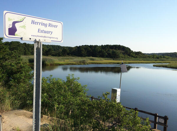
The Herring River from Chequesset Neck Road dike, facing upstream, Wellfleet, Massachusetts
The Herring River from Chequesset Neck Road dike, facing upstream, Wellfleet, MassachusettsHerring River Estuary, Wellfleet, Massachusetts

Flooded Road near USGS gaging station 01055500 in Turner, Maine
Flooded Road near USGS gaging station 01055500 in Turner, MaineStop sign at the end of School House Hill Rd in Turner, Maine near USGS gaging station 01055500 on the Nezinscot River.
Flooded Road near USGS gaging station 01055500 in Turner, Maine
Flooded Road near USGS gaging station 01055500 in Turner, MaineStop sign at the end of School House Hill Rd in Turner, Maine near USGS gaging station 01055500 on the Nezinscot River.