
Groundwater well serving private residence in Loudon, New Hampshire.
Images
Click through our gallery of photographs showcasing New England Water Science Center research projects and monitoring work throughout the region.
Filter Total Items: 601

Private domestic well in Loudon, New Hampshire
Groundwater well serving private residence in Loudon, New Hampshire.

Flooding around Mill River streamflow gage 01171500 at Northampton, MA
Flooding around Mill River streamflow gage 01171500 at Northampton, MAFlooding around Mill River USGS streamflow gage 01171500 at Northampton, Massachusetts.
Flooding around Mill River streamflow gage 01171500 at Northampton, MA
Flooding around Mill River streamflow gage 01171500 at Northampton, MAFlooding around Mill River USGS streamflow gage 01171500 at Northampton, Massachusetts.

Beehive Lagoon - Acadia National Park, Maine
Beehive Lagoon - Acadia National Park, Maine: View from the Sand Beach, September 19, 2015
Beehive Lagoon - Acadia National Park, Maine: View from the Sand Beach, September 19, 2015

Mystic River at Medford, MA
Mystic River at Medford, MA in the vicinity of the streamgage station 01103040.
Mystic River at Medford, MA in the vicinity of the streamgage station 01103040.
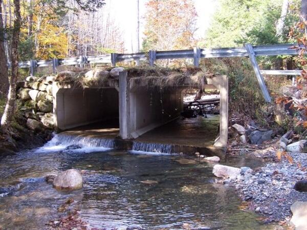
Original Box Culverts on Bronson Brook at Dingle Road in Worthington, Massachusetts
Original Box Culverts on Bronson Brook at Dingle Road in Worthington, MassachusettsThis photos shows the box culverts installed at Bronson Brook at Dingle Road in Worthington, Massachusetts. This undersized stream crossing has been renovated to increase habitat connectivity.
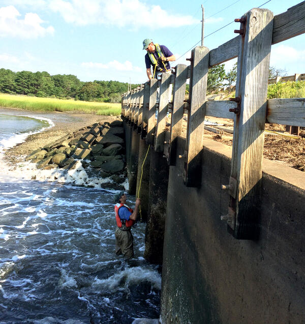
USGS staff installing monitoring equipment on the Chequessett Neck Road dike, Wellfleet, Massachusetts
USGS staff installing monitoring equipment on the Chequessett Neck Road dike, Wellfleet, MassachusettsUSGS staff installing monitoring equipment on the Chequessett Neck Road dike, Wellfleet, Massachusetts.

Streamgage 01115110 in Rhode Island
Photograph of monitoring station at U.S. Geological Survey streamgage 01115110, Huntinghouse Brook at Elmdale Road near North Scituate, Rhode Island.
Photograph of monitoring station at U.S. Geological Survey streamgage 01115110, Huntinghouse Brook at Elmdale Road near North Scituate, Rhode Island.

Sampling system used to collect composite samples of stormflow
Sampling system used to collect composite samples of stormflowPhotograph of the sampling system used to collect flow-proportional filtered and nonfiltered composite samples of stormflow at the 01115110, Huntinghouse Brook at Elmdale Road near North Scituate, Rhode Island, streamgage.

Ice Jam Remnants
On April 29, hydrologic technicians Anthony Underwood and Jeremiah Pomerleau visited the USGS gaging station on the St. John River at Ninemile Bridge and found a sea of broken up, dirty ice left behind by a recent ice jam.
According to Anthony, photos don't do the size and scale of the ice chunks any justice.

Preparing geophysical equipment for deployment
USGS scientists Carol Johnson, Eric White and Tim McCobb prepare geophysical equipment for deployment in a coastal embayment April 9, 2015 in Falmouth, Massachusetts.
USGS scientists Carol Johnson, Eric White and Tim McCobb prepare geophysical equipment for deployment in a coastal embayment April 9, 2015 in Falmouth, Massachusetts.

Double Coverage
Hydrologist Charlie Culbertson holds an acoustic velocity meter under the ice covered river while standing under the covered bridge over the Ellis River at South Andover, Maine. This meter is used to collect streamflow information through the ice during the winter period.
Hydrologist Charlie Culbertson holds an acoustic velocity meter under the ice covered river while standing under the covered bridge over the Ellis River at South Andover, Maine. This meter is used to collect streamflow information through the ice during the winter period.

Winter Morning Streamgaging
On January 14, 2015, hydrologic technicians Jeff Kinsey (shown) and Nick Stasulis visited USGS gaging station 01030500 on the Mattawamkeag River.
On January 14, 2015, hydrologic technicians Jeff Kinsey (shown) and Nick Stasulis visited USGS gaging station 01030500 on the Mattawamkeag River.

Treated Wastewater from Joint Base Cape Cod was Discharged
Treated Wastewater from Joint Base Cape Cod was DischargedTreated wastewater from Joint Base Cape Cod was discharged to rapid-infiltration disposal beds from 1936 to 1995. The disposal formed a groundwater contamination plume that extends more than 10 kilometers in the Cape Cod sand and gravel glacial outwash aquifer.

Bridge-deck scuppers draining into the Charles River
Bridge-deck scuppers draining into the Charles RiverPhotograph of bridge-deck scuppers draining into the Charles River on State Route 2A in Boston near U.S. Geological Survey bridge-deck-monitoring station 422108071052501 during a rainstorm.
Bridge-deck scuppers draining into the Charles River
Bridge-deck scuppers draining into the Charles RiverPhotograph of bridge-deck scuppers draining into the Charles River on State Route 2A in Boston near U.S. Geological Survey bridge-deck-monitoring station 422108071052501 during a rainstorm.
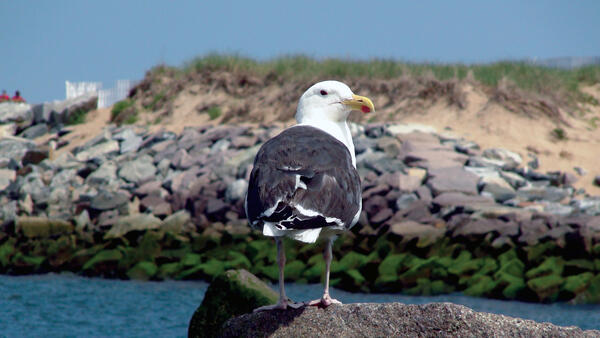
Great Black‑backed Gull at Plum Island, Massachusetts
Great Black‑backed Gull at Plum Island, MassachusettsA Great Black‑backed Gull stands on a rock at Plum Island, MA, looking out over the water with the sand dunes behind it. Its bright white head and big yellow beak stand out against its dark wings.

Drilling on Maravista peninsula in Falmouth MA
Drilling on Maravista peninsula in Falmouth, Massachusetts
Drilling on Maravista peninsula in Falmouth, Massachusetts

USGS Scientists Collecting Water-Quality Samples from Shallow Groundwater under Ashumet Pond
USGS Scientists Collecting Water-Quality Samples from Shallow Groundwater under Ashumet PondU.S. Geological Survey (USGS) scientists collecting water-quality samples from shallow groundwater under Ashumet Pond, Cape Cod, Massachusetts.

Sampling of Groundwater discharging through the bottom of a pond
Sampling of Groundwater discharging through the bottom of a pondSampling of Groundwater discharging through the bottom of a pond.
Location: Cape Cod, Massachusetts
Sampling of Groundwater discharging through the bottom of a pond
Sampling of Groundwater discharging through the bottom of a pondSampling of Groundwater discharging through the bottom of a pond.
Location: Cape Cod, Massachusetts

Ashumet Pond, Cape Cod with sample grid markers
Sunset view looking northwest from Fishermans Cove, across Ashumet Pond, Cape Cod, Massachusetts. The small sticks and flags in the lake are a sampling grid.
Sunset view looking northwest from Fishermans Cove, across Ashumet Pond, Cape Cod, Massachusetts. The small sticks and flags in the lake are a sampling grid.

Leaf Me Alone!
In this photo, Joseph Whittier, a student with the Maine Office of the New England Water Science Center, takes a break from scooping leaves to pose for a photo.
In this photo, Joseph Whittier, a student with the Maine Office of the New England Water Science Center, takes a break from scooping leaves to pose for a photo.

Sudbury Dam, Massachusetts
Sudbury Dam located in Southborough Massachusetts was built in 1894. A storehouse was built in 1900.
Sudbury Dam located in Southborough Massachusetts was built in 1894. A storehouse was built in 1900.