
USGS groundwater well (Ma-Wkw 2R) in Wayland, Massachusetts with holiday decorations.
Images
Click through our gallery of photographs showcasing New England Water Science Center research projects and monitoring work throughout the region.
Filter Total Items: 601

USGS groundwater well with Holiday Decorations
USGS groundwater well (Ma-Wkw 2R) in Wayland, Massachusetts with holiday decorations.

USGS employee showing holiday spirit at groundwater well
USGS employee showing holiday spirit at groundwater wellHydrologic technician performing an electric tape down measurement of a real-time recording groundwater well station while showing some holiday spirit.
USGS employee showing holiday spirit at groundwater well
USGS employee showing holiday spirit at groundwater wellHydrologic technician performing an electric tape down measurement of a real-time recording groundwater well station while showing some holiday spirit.

USGS groundwater well in front of a large maple tree
USGS groundwater well in front of a large maple treeA USGS groundwater well in front of an large maple tree. The station ID is: 415710071402201 RI-BUW 187 located in Burrillville, Rhode Island.
USGS groundwater well in front of a large maple tree
USGS groundwater well in front of a large maple treeA USGS groundwater well in front of an large maple tree. The station ID is: 415710071402201 RI-BUW 187 located in Burrillville, Rhode Island.

Housatonic channel measurements
FEMA Flood Insurance Rate Maps.
A two teams of two USGS employees measured structures and channel cross sections along a section of the Housatonic River.
FEMA Flood Insurance Rate Maps.
A two teams of two USGS employees measured structures and channel cross sections along a section of the Housatonic River.

Channel surveying using total station
Paul Solis gets the rod into the channel for total station work on the West Aspetuck River which is being surveyed as part of our cooperation with FEMA. This is 11/21/19 on the West Aspetuck River just north of New Milford, CT.
Paul Solis gets the rod into the channel for total station work on the West Aspetuck River which is being surveyed as part of our cooperation with FEMA. This is 11/21/19 on the West Aspetuck River just north of New Milford, CT.

Surveying a bridge in Connecticut
Surface Water Modeling for FEMA Flood Insurance Rate Maps.
Hydrologic Technician Brendan McCarthy and Alex Butcher set up a total station near a covered bridge on the Housatonic River in Connecticut.
A crew of two teams worked on measuring structures and channel cross sections along a reach of the Housatonic River.

Drillers using a sonic drilling rig to install monitoring wells
Drillers using a sonic drilling rig to install monitoring wellsDrillers from the Environmental Protection Agency Office of Research and Development (Ada, OK) using a sonic drilling rig to install monitoring wells in Barnstable, Massachusetts.

Surveying at the Tide Gage in Connecticut
Hydrologic technician operates a survey gun to calibrate the equipment used to measure the water elevation at the tide gage 01194815 located in Old Saybrook, Connecticut.
Hydrologic technician operates a survey gun to calibrate the equipment used to measure the water elevation at the tide gage 01194815 located in Old Saybrook, Connecticut.
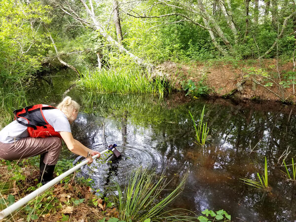
Water quality sample collection at Herring River in Wellfleet, Massachusetts
Water quality sample collection at Herring River in Wellfleet, MassachusettsCape Cod National Seashore (CACO) NPS staff collecting a water quality sample at Station 20, Herring River in Wellfleet, Massachusetts as a part of the large-scale Herring River Restoration Project. The Station 20 site is one of three sites to monitor dissolved oxygen concentrations.
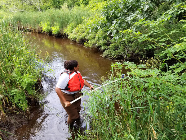
Water quality sample collection at Herring River estuary in Wellfleet, Massachusetts
Water quality sample collection at Herring River estuary in Wellfleet, MassachusettsCape Cod National Seashore (CACO) NPS staff collecting a water quality sample at Station 14, Herring River in Wellfleet, Massachusetts as a part of the large-scale Herring River Restoration Project. The Station 14 site is one of 11 sites which samples were analyzed for concentrations of sediment, chlorophyll, nitrogen, and phosphorus.

Meteorological Weather and Real-Time Groundwater Site Inspection
Meteorological Weather and Real-Time Groundwater Site InspectionShown in this photo is Hydrologic Technician Sam Banas performing a routine site inspection of this meteorological weather and real-time groundwater well station.
Meteorological Weather and Real-Time Groundwater Site Inspection
Meteorological Weather and Real-Time Groundwater Site InspectionShown in this photo is Hydrologic Technician Sam Banas performing a routine site inspection of this meteorological weather and real-time groundwater well station.

Scenic photo of the North River in Shattuckville, Massachusetts
Scenic photo of the North River in Shattuckville, MassachusettsScenic photo of the North River in Shattuckville, Massachusetts taken during a cloudy day.
Scenic photo of the North River in Shattuckville, Massachusetts
Scenic photo of the North River in Shattuckville, MassachusettsScenic photo of the North River in Shattuckville, Massachusetts taken during a cloudy day.

Modeling FEMA Flood Insurance Rate Maps
Surface Water Modeling for FEMA Flood Insurance Rate Maps.
USGS employee using survey data to model water surface elevation for different storm events.
Surface Water Modeling for FEMA Flood Insurance Rate Maps.
USGS employee using survey data to model water surface elevation for different storm events.

Locating survey site using Collector app
Surface Water Modeling for FEMA Flood Insurance Rate Maps.
USGS employee uses Collector App to locate the survey site.
Surface Water Modeling for FEMA Flood Insurance Rate Maps.
USGS employee uses Collector App to locate the survey site.

Setting up a total station on the edge of a field
Surface Water Modeling for FEMA Flood Insurance Rate Maps.
USGS employees are setting up a total station on the edge of a field in preparation to make a channel measurement.
Surface Water Modeling for FEMA Flood Insurance Rate Maps.
USGS employees are setting up a total station on the edge of a field in preparation to make a channel measurement.

Setting up a total station near an old factory
Surface Water Modeling for FEMA Flood Insurance Rate Maps.
USGS employees are setting up a total station near an old factory in preparation of taking a channel measurement.
Surface Water Modeling for FEMA Flood Insurance Rate Maps.
USGS employees are setting up a total station near an old factory in preparation of taking a channel measurement.

Hiking in to the survey site
Surface Water Modeling for FEMA Flood Insurance Rate Maps.
USGS employees carry survey equipment to the survey site. They are hiking down a grassy hill in a farmers field in Connecticut.
Surface Water Modeling for FEMA Flood Insurance Rate Maps.
USGS employees carry survey equipment to the survey site. They are hiking down a grassy hill in a farmers field in Connecticut.

Digging a hole next to a real-time groundwater well for a solar panel
Digging a hole next to a real-time groundwater well for a solar panelShown in this photo is student intern Michael Upton digging a hole next to a real-time groundwater well so a solar panel and cell phone modem antenna mast can be installed. The site ID is: 421240072490201 MA-M7W 19 located in Montgomery, Massachusetts.

Checking preliminary maps
FEMA Flood Insurance Rate Maps.
USGS employee is checking Preliminary Flood Insurance Rate Maps before a meeting.
FEMA Flood Insurance Rate Maps.
USGS employee is checking Preliminary Flood Insurance Rate Maps before a meeting.

FEMA Bridge Survey
Surface Water Modeling for FEMA Flood Insurance Rate Maps.
USGS employees survey a bridge.
Surface Water Modeling for FEMA Flood Insurance Rate Maps.
USGS employees survey a bridge.

Highway monitoring station
Highway monitoring station USGS 415157072291301 along State Route 74 near Vernon, Connecticut.
Highway monitoring station USGS 415157072291301 along State Route 74 near Vernon, Connecticut.