
Example of new Open-Graded Friction Course (OGFC) pavement layer at the start of the project. OGFC, commonly referred to as porous pavement, is a layer of porous asphalt spread over the surface of impervious hot mix or dense-graded asphalt (HMA) that is traditionally used as the wearing surface in Massachusetts.
Images
Click through our gallery of photographs showcasing New England Water Science Center research projects and monitoring work throughout the region.
Filter Total Items: 601

Open-Graded Friction Course pavement
Example of new Open-Graded Friction Course (OGFC) pavement layer at the start of the project. OGFC, commonly referred to as porous pavement, is a layer of porous asphalt spread over the surface of impervious hot mix or dense-graded asphalt (HMA) that is traditionally used as the wearing surface in Massachusetts.

Cape Cod National Seashore
A look to the north along the bluffs at the Cape Cod National Seashore, from Marconi Station. Over the years, the USGS continues to work with the National Park Service at the Cape Cod National Seashore.
A look to the north along the bluffs at the Cape Cod National Seashore, from Marconi Station. Over the years, the USGS continues to work with the National Park Service at the Cape Cod National Seashore.

Water quality at the Salmon River
Installing dissolved oxygen sensors at the Salmon River near East Hampton, Connecticut
Installing dissolved oxygen sensors at the Salmon River near East Hampton, Connecticut

Hydrologic technician making a streamflow measurement
Hydrologic technician making a streamflow measurementHydrologic technician making a streamflow measurement using a FlowTracker ADV in a river.
Hydrologic technician making a streamflow measurement
Hydrologic technician making a streamflow measurementHydrologic technician making a streamflow measurement using a FlowTracker ADV in a river.
Webster Lake, Massachusetts
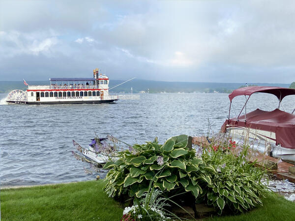
Webster Lake—formally known as Chargoggagoggmanchauggagoggchaubunagungamaugg, the longest place name in the United States—is a 1,442‑acre freshwater lake in central Massachusetts. The lake contributes to the French River watershed through inflow from small tributaries and supports recreational boating, including the paddle‑wheel tour boat shown here.
Webster Lake—formally known as Chargoggagoggmanchauggagoggchaubunagungamaugg, the longest place name in the United States—is a 1,442‑acre freshwater lake in central Massachusetts. The lake contributes to the French River watershed through inflow from small tributaries and supports recreational boating, including the paddle‑wheel tour boat shown here.

Initial construction of trench and metering manhole
Initial construction of trench and metering manholeInitial construction of trench and metering manhole. Trench collects runoff from the respective pavement type and conveys the water to a metering manhole buried adjacent to the highway.
Initial construction of trench and metering manhole
Initial construction of trench and metering manholeInitial construction of trench and metering manhole. Trench collects runoff from the respective pavement type and conveys the water to a metering manhole buried adjacent to the highway.

Connecticut River in Northfield MA outreach event
An outreach event taking place in the vicinity of the USGS-01161280 streamgage site Connecticut River in Northfield MA.
An outreach event taking place in the vicinity of the USGS-01161280 streamgage site Connecticut River in Northfield MA.

Aquifer Testing
USGS scientists performing a Groundwater Integrity Test by pumping the well with a Grundfos Submersible Pump. One of the scientists checks the pump rate in 5 gallon buckets, while the other one checks the water level and rate drop off in the well with an electric tape.
USGS scientists performing a Groundwater Integrity Test by pumping the well with a Grundfos Submersible Pump. One of the scientists checks the pump rate in 5 gallon buckets, while the other one checks the water level and rate drop off in the well with an electric tape.

Sakonnet River, the eastern arm of the Narragansett Bay, Rhode Island
Sakonnet River, the eastern arm of the Narragansett Bay, Rhode IslandView of the Sakonnet River, the eastern arm of the Narragansett Bay, Rhode Island.
Sakonnet River, the eastern arm of the Narragansett Bay, Rhode Island
Sakonnet River, the eastern arm of the Narragansett Bay, Rhode IslandView of the Sakonnet River, the eastern arm of the Narragansett Bay, Rhode Island.

Collecting a water-quality sample
New England WSC hydrologic technician collecting a water-quality sample at Maple Meadow Brook, Wilmington, MA.
New England WSC hydrologic technician collecting a water-quality sample at Maple Meadow Brook, Wilmington, MA.

Flooding in Soldier Pond, Maine
Flooding in Soldier Pond, Maine, following rainfall and snowmelt that led to high water levels in the Fish and St. John Rivers in April and May of 2018.
Flooding in Soldier Pond, Maine, following rainfall and snowmelt that led to high water levels in the Fish and St. John Rivers in April and May of 2018.

Rapid Deployment Gage in Soldier Pond, Maine
USGS field crews installed a temporary rapid deployment gage on May 2, 2018, at Soldier Pond in the Fish River to monitor flooding near Fort Kent in Maine.
USGS field crews installed a temporary rapid deployment gage on May 2, 2018, at Soldier Pond in the Fish River to monitor flooding near Fort Kent in Maine.

Flooding in Soldier Pond, Maine
Flooding in Soldier Pond, Maine, following rainfall and snowmelt that led to high water levels in the Fish and St. John Rivers in April and May of 2018.
Flooding in Soldier Pond, Maine, following rainfall and snowmelt that led to high water levels in the Fish and St. John Rivers in April and May of 2018.

Slotted collector pipe for shallow dug well
A horizontal collector is a part of a novel shallow well design that might be able to provide safe drinking water to domestic well users in arsenic-prone parts of the Nation.
A horizontal collector is a part of a novel shallow well design that might be able to provide safe drinking water to domestic well users in arsenic-prone parts of the Nation.

Novel dug well installation
A novel shallow well design might be able to provide safe drinking water to domestic well users in arsenic-prone parts of the Nation. Casing and collector being lowered into well excavation during the test.
A novel shallow well design might be able to provide safe drinking water to domestic well users in arsenic-prone parts of the Nation. Casing and collector being lowered into well excavation during the test.

Completing a novel dug well installation
Completing a novel dug well installation. A study of a novel shallow well design that might be able to provide safe drinking water to domestic well users in arsenic-prone parts of the Nation.
Completing a novel dug well installation. A study of a novel shallow well design that might be able to provide safe drinking water to domestic well users in arsenic-prone parts of the Nation.

Installed dug well at Maple Syrup farm
Dug well with instrumentation on a testing site of the novel shallow well design that might be able to provide safe drinking water to domestic well users in arsenic-prone parts of the Nation.
Dug well with instrumentation on a testing site of the novel shallow well design that might be able to provide safe drinking water to domestic well users in arsenic-prone parts of the Nation.

USGS Storm-Tide Sensor
USGS storm-tide sensor bolted to a cement jetty on the Atlantic Ocean coast at Fire Island, New York. USGS scientists deployed over 50 sensors along the coast of Maine, New Hampshire, Massachusetts, Rhode Island, Connecticut, New York, New Jersey and Delaware to study a Nor'easter that affected the Northeast in March of 2018.
USGS storm-tide sensor bolted to a cement jetty on the Atlantic Ocean coast at Fire Island, New York. USGS scientists deployed over 50 sensors along the coast of Maine, New Hampshire, Massachusetts, Rhode Island, Connecticut, New York, New Jersey and Delaware to study a Nor'easter that affected the Northeast in March of 2018.

USGS Deploys Storm-Tide Sensors
USGS hydrologic technician deploys storm-tide sensor in Cohasset, MA. They are being installed on bridges, piers, and other structures that have a good chance of surviving the storm.
USGS hydrologic technician deploys storm-tide sensor in Cohasset, MA. They are being installed on bridges, piers, and other structures that have a good chance of surviving the storm.

Measuring a high-water mark during blizzard of January 2018 in New England
Measuring a high-water mark during blizzard of January 2018 in New EnglandScientist measuring high-water mark at the Yacht Club in Hull, MA. Blizzard of January 2018 in New England.
Measuring a high-water mark during blizzard of January 2018 in New England
Measuring a high-water mark during blizzard of January 2018 in New EnglandScientist measuring high-water mark at the Yacht Club in Hull, MA. Blizzard of January 2018 in New England.