
New England Water Science Center Projects
The New England Water Science Center monitors, analyzes, and communicates information on the quality and movement of surface water and groundwater within the states of Connecticut, Maine, Massachusetts, New Hampshire, Rhode Island, and Vermont.
Explore our projects to learn more about the scientific investigations we conduct. Use keywords and the available filters to narrow your search scope.
Explore Our Projects
Explore Our Projects
Filter Total Items: 108

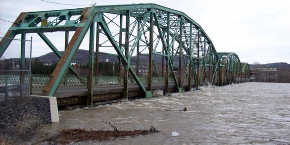
Monitoring Merrimack River Mainstem and Tidal Reaches in Massachusetts to Evaluate Water Quality Conditions, May to September 2020
The Merrimack River watershed, the 4th largest watershed in New England (Massachusetts Executive Office of Environmental Affairs, 2001), has seen substantial growth and development in recent years.

New England Drought Information
Droughts are one of the most expensive and damaging hydrologic hazards in the United States. They are generally slow in developing, frequently occur over a long period of time, and can affect large areas and populations.
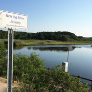
Herring River Water-Quality Data
This storytelling explores the availability of water-quality data collected by the Cape Cod National Seashore and U.S. Geological Survey in support of the Herring River restoration project. It highlights the development of the monitoring program since the 1980s and the publication of Cape Cod National Seashore data in a U.S. Geological Survey data release.

Measurement and Modeling of Nitrogen Discharge to Cape Cod Rivers to Identify High-Priority Nitrogen Reduction Areas
In 2019 USGS and the U.S. Environmental Protection Agency (EPA) Region 1 initiated a study to measure spatial and temporal patterns of nitrogen loading in selected rivers on Cape Cod and then determine whether the measured patterns can be related to nitrogen source areas in the surrounding watersheds to prioritize nitrogen reduction efforts. Study results will improve understanding of nitrogen...

Hydrologic Monitoring in the Three Bays Watershed in Support of Nutrient Management Activities, Cape Cod, Massachusetts
In 2019 the USGS began a partnership with the U.S. Environmental Protection Agency (EPA) Office of Research and Development (ORD), EPA Region 1 Southeast New England Program for Coastal Watershed Restoration (SNEP), Barnstable Clean Water Coalition (BCWC), and other stakeholders to conduct hydrologic monitoring and assessment in support of multifaceted nutrient-management activities in the Three...

Arsenic Variability in Water-Supply Wells
The USGS, in cooperation with the Town of Seabrook, New Hampshire and a private well owner, is assessing the variability of arsenic over multiple time scales. A network of three wells is being used to monitor changes in arsenic, arsenic species, a host of other chemical constituents, and the distribution of ages of groundwater entering the wells. The wells—one domestic bedrock aquifer well, one...

New England Water Use
Monthly water use estimates for New England and the rest of the conterminous U.S. are now available for the three largest categories of use in the United States: public supply, crop irrigation, and thermoelectric power generation.

Herring River Water Quality
The U.S. Geological Survey (USGS) New England Water Science Center installed, operated, and maintained surface water-quality sites at the Chequessett Neck Road dike on the Herring River from November 2015 through September 2018.

Development of a Water Quality Monitoring Strategy for Mount Hope Bay and the Taunton River Estuary, Massachusetts
The U.S. Geological Survey (USGS) and Massachusetts Department of Environmental Protection (MassDEP) are collaborating on a study to develop a water quality monitoring strategy for Mount Hope Bay and the Taunton River Estuary.

Water Quality Data Collection to Support Aluminum Criteria Development in Massachusetts
The U.S. Geological Survey (USGS) and Massachusetts Department of Environmental Protection (MassDEP) are collaborating on a study to collect water-quality data at streams and ponds in Massachusetts that receive aluminum discharges from wastewater treatment (WWTF) or public-water supply (PWS) facilities. The objective of this study is to inform the development of MassDEP guidelines on discharge...

Water Quality Sampling and Monitoring of the Pawcatuck River Watershed
The Pawcatuck River and the Pawcatuck River Estuary and Little Narragansett Bay form part of the boundary between the States of Connecticut and Rhode Island. Both states have identified water quality impairments within these waters related to nutrients (insufficient oxygen) and bacteria. Studies of the eutrophication potential of Long Island Sound embayments have identified that the Pawcatuck...

Recharge Estimates for Maine: 25-year Average, Range, and Uncertainty, 1990-2015
The USGS Soil-Water-Balance model (SWB) has been used to estimate potential recharge across the State of Maine. The average and range (minimum and maximum) of annual recharge were estimated for the 25-year period from 1990 to 2015. Datasets of estimated recharge and the modeled uncertainty in the recharge estimates are available for download.

Assessment of Potential Effects of Water-Supply Withdrawals on Groundwater Levels near the Hyannis Ponds Complex, Barnstable, Massachusetts
The USGS, in cooperation with the Town of Barnstable and MassWildlife, is assessing the potential effects of new water-supply withdrawals on groundwater levels in the Hyannis Ponds Wildlife Management Area on Cape Cod. A groundwater-flow model is being used to simulate the effects of several possible withdrawal and wastewater-return flow scenarios developed by the Town of Barnstable and...

Development of a Regional-Scale Model to Simulate Groundwater Flow and Nitrogen Loading in Watersheds Along the Connecticut Coast of Long Island Sound
In 2018 USGS began work on the development of regional-scale groundwater flow and nitrogen transport models of areas along the Connecticut coast. The model will be used as a quantitative tool to evaluate groundwater flow and nitrogen loading to Long Island Sound.

Hydrologic Site Assessment for Passive Treatment of Groundwater Nitrogen with Permeable Reactive Barriers, Cape Cod, Massachusetts
In 2019 USGS completed a study designed to develop and evaluate a phased site-assessment approach for determining the hydrologic suitability of sites being considered for permeable reactive barrier installation on Cape Cod. The approach provides a template for town officials and other stakeholders to follow when considering PRBs for passive treatment of nitrogen in groundwater on Cape Cod and...

USGS Publications on the Water Resources of Cape Cod and Southeastern Massachusetts
The U.S. Geological Survey (USGS) has been investigating groundwater and surface-water resources on Cape Cod for more than 50 years. Recent studies have focused on the sources of water to public-supply wells, ponds, streams, and coastal areas; transport and discharge of nitrogen and contaminants of emerging concern derived from domestic and municipal wastewater disposal; fate and transport of...

The Connecticut Streamflow and Sustainable Water Use Estimator: A Decision-Support Tool to Estimate Streamflow and Water Availability at Ungaged, User-Defined Stream Locations in Connecticut
The Connecticut streamflow and sustainable water use estimator is a decision-support tool that provides estimates of daily unaltered streamflow, water-use adjusted streamflow (for the portions of the state where water-use data are available), and water availability for ungaged, user-defined sites in Connecticut.

Estimation of Daily Streamflow and Water Availability in the Massachusetts Sustainable-Yield Estimator, Version 2.0
The Massachusetts Sustainable-Yield Estimator is a decision-support tool that provides estimates of daily unaltered streamflow, water-use-adjusted streamflow, and water availability for ungaged, user-defined sites in Massachusetts. In this recently completed study, version 2.0 of the original Sustainable-Yield Estimator (Archfield and others, 2010) was developed with minor changes to the...

Assessment of Hydrologic and Water-Quality Changes in Shallow Groundwater Beneath a Coastal Neighborhood Being Converted from Septic Systems to Municipal Sewers
The U.S. Geological Survey and the U.S. Environmental Protection Agency are collaborating on a study to better understand changes to groundwater quality beneath a densely developed coastal neighborhood as it undergoes conversion from onsite wastewater disposal to municipal sewering.

Geospatial Dataset of Wells and Attributes in the New England Groundwater Level Network, 2017
The drought of 2016 affected hydrologic conditions throughout New England. Responses of USGS groundwater observation wells to this event, however, were not uniform and were sometimes markedly different from site to site. Although USGS scientists were able to provide explanations for most of these situations, the event highlighted the need for additional well information to develop quantitative and...

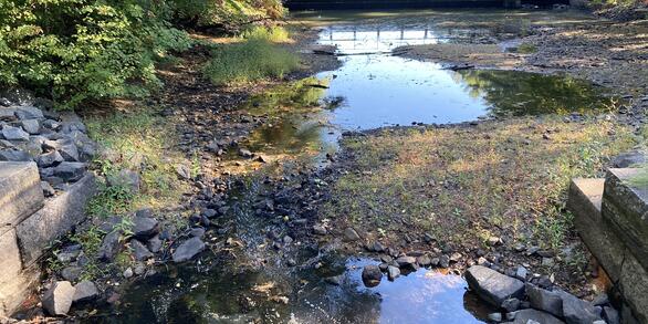
Groundwater and Surface-Water Monitoring in the Mill Creek Watershed, Wellfleet and Truro, Massachusetts
The Herring River estuary and salt marsh system, within the Cape Cod National Seashore in Wellfleet, Massachusetts, has been diked off from the ocean for more than 100 years. The National Park Service is now preparing to restore the 1,100 acre estuary-marsh system.