
New England Water Science Center Projects
The New England Water Science Center monitors, analyzes, and communicates information on the quality and movement of surface water and groundwater within the states of Connecticut, Maine, Massachusetts, New Hampshire, Rhode Island, and Vermont.
Explore our projects to learn more about the scientific investigations we conduct. Use keywords and the available filters to narrow your search scope.
Explore Our Projects
Explore Our Projects
Filter Total Items: 108

Satellite-based Remote Sensing of River Discharge
The U.S. Geological Survey and NASA are collaborating on a study to develop methods to estimate river flows from satellite observations.

Characterizing Future Climate and Hydrology in Massachusetts using Stochastic Modeling Methods
Communities across Massachusetts may face potential consequences of climate change, ranging from more extreme rainfall to more pronounced and frequent droughts. Climate change could alter the state’s hydrology in potentially complex and unanticipated ways. Typical approaches for projecting hydrologic risk under climate change can misrepresent and underestimate the variability of climate and...

Predictive Analysis of Water Demand for Providence, Rhode Island
The Providence Water Supply Board (Providence Water) and the U.S. Geological Survey (USGS) are collaborating on a study to predict future water demand in and around the city of Providence.

Base-Flow Water Quality Sampling in Small Basins Draining to Long Island Sound
During the past 20 years, nitrogen loads to Long Island Sound (LIS) have been substantially reduced in large watersheds affected by municipal wastewater loads.

Research on Per- and Polyfluoroalkyl Substances (PFAS) in the New England Water Science Center
Per- and polyfluoroalkyl substances (PFAS) are a diverse group of over 4,000 different compounds. Since the 1940s, PFAS have been manufactured and used around the globe, including in the United States. PFAS are resistant to chemical and thermal breakdown and impart stain and water-resistance properties, making them useful for a variety of commercial applications, but also persistent in the...

USGS Groundwater data for Connecticut
This web page provides the user with access to a table showing current conditions for active groundwater level sites, historical observations, and various summary statistics for both currently active and discontinued sites, for stations in Connecticut.
Connecticut Active Water Level Network
This site provides an interactive map with symbols showing locations of groundwater level measurement sites in New England. The symbols are color coded to indicate percentile classes and whether the sites report data in real-time-delivered to NWISWEB, continuous or periodic measurements.
Water Quality Monitoring of Merrimack River Watershed
The U.S. Geological Survey, in cooperation with the Massachusetts Department of Environmental Protection (MassDEP), is currently conducting a 4-year water-quality investigation in the lower portion of the Merrimack River watershed, April 2020 – October 2024.

Water Quality Sampling in the Tributaries of the Long Island Sound
Coastal estuaries in southern New England and New York show the effects of excess nutrients and coastal eutrophication. These include excessive growth of macroalgae, excessive blooms of phytoplankton, oxygen depletion, hypoxia and deteriorated substrates. State and Federal regulators have responded to these nutrient-caused impairments by requiring more stringent permit limits for National...

Chloride Data for Streams in Connecticut, Massachusetts, and Rhode Island
As part of water-quality data collection activities in New England, water samples are analyzed for chloride in monitoring networks and projects across Connecticut, Massachusetts, and Rhode Island. Chloride is of interest because high concentrations may affect aquatic life in streams or affect water quality of reservoirs and aquifers used for drinking water.

Flood Documentation and Inundation Mapping of the January and March 2018 Nor’easters in Coastal Massachusetts
2018 Nor’easters in Coastal Massachusetts

Embayment Monitoring to Support Nutrient Management Activities in Connecticut for Long Island Sound
The USGS, in cooperation with the Connecticut Department of Energy and Environmental Protection will be collecting water-quality and hydrologic data at six embayments from April 2021 to June 2027: Mystic, Norwalk, Saugatuck, Sasco-Southport complex, Farm, and Poquonnock.
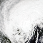
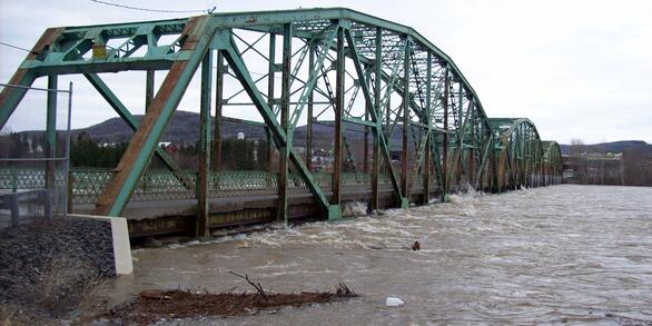
Tropical Storm Irene in New England, 2011
Tropical Storm Irene arrived in New England on August 28, 2011, bringing extreme winds, rapidly changing pressure, and record-setting rainfall to the region. Over the next 18 hours, the resulting coastal flooding and historic riverine flooding resulted in damages estimated to be in excess of $7 billion and approximately 45 deaths (Suro and others, 2015). The U.S. Geological Survey (USGS) was...

Remembering Tropical Storm Irene in New England
On August 28, 2011 Tropical Storm Irene made landfall in New England, leading to coastal storm surge, significant riverine flooding, sediment transport to Long Island Sound, and major infrastructure damage and destruction. Ten years later, the USGS New England Water Science Center looks back at Irene, the data collected by our Center during the event, the response by our employees before, during...

Transportation-Related Water Projects in New England
The New England Water Science Center collects data and does interpretive studies on hydrology, hydraulics, and water quality in cooperation with the Federal Highway Administration and State Departments of Transportation (DOTs) in New England and other states.

Long-Term Data Collection Provides Insight to Changes in Water Resources in New England
Primarily through the efforts of Glenn Hodgkins and Robert Dudley, the New England Water Science Center has been studying historical changes in streamflows, groundwater levels, and lake ice in New England and across the country for 20 years. Glenn and Rob have analyzed a wealth of historical data, including 100+ years of streamflow data and 150+ years of lake-ice data at some locations...

Water Quality Monitoring in the Scituate Reservoir Drainage Area, Rhode Island
The Scituate Reservoir system is the largest inland body of water in Rhode Island and the principal drinking-water supply for more than 60 percent of the State’s population. The system includes the Scituate Reservoir and five tributary reservoirs with a maximum storage capacity of 37 billion gallons. The drainage basin that contributes water to the reservoir extends across 93 square miles in...

Assessment of Nutrient Transport and Discharge to Coastal Embayments, Wickford, Rhode Island
In 2020, the USGS began a partnership with the U.S. Environmental Protection Agency (EPA) Region 1 Southeast New England Program for Coastal Watershed Restoration (SNEP) and EPA Office of Research and Development (ORD), Atlantic Coastal Sciences Division, Narragansett, RI in support of water-quality and ecological monitoring being conducted by ORD in the coastal waters around Wickford, RI. The...

Sleepers River Research Watershed
The Sleepers River Research Watershed in Danville, Vermont has been the site of active hydrologic research since 1959, when the Agricultural Research Service (ARS) of the U.S. Department of Agriculture (USDA) established a research program in the watershed. The Sleepers River site is now operated by the USGS, in cooperation with several other Federal agencies and universities.

New England Flood Information
The USGS delivers continuous streamflow, stage (water-level), and tide data to help emergency managers and other decision makers protect life and property caused by floods and other water-related hazards.

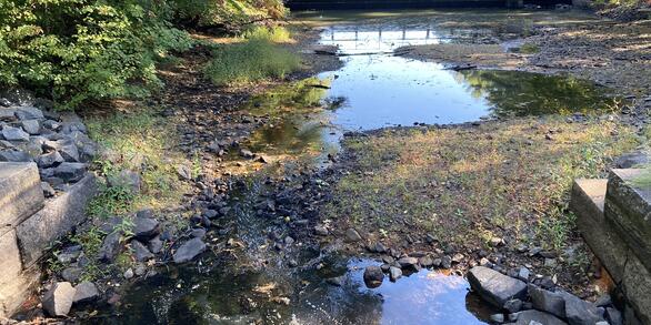
New England Drought, 2020
Below average and infrequent rainfall from May through September 2020 led to an extreme hydrologic drought across much of New England, with some areas experiencing a flash (quick-onset) drought.