
Surface Water
Surface Water
Surface Water
Filter Total Items: 30
Tidal Discharge at USGS Streamgages
New Jersey has an extensive coastline with several rivers and streams close enough to interact with the bays and ocean. This interaction causes many waterways to be affected by the tidal actions of the ocean. Because there are no dams along these rivers, this effect can be felt some distance upstream requiring specialized observational techniques to measure and calculate discharge from these...

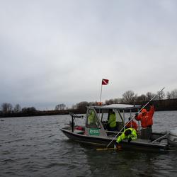
Microbial Source Tracking in the Lower Passaic River Basin Study Area, New Jersey
The USGS NJWSC is collaborating with the Passaic Valley Sewerage Commission (PVSC) on an Urban Waters Federal Partnership project in the Lower Passaic River basin to investigate the occurrence and potential sources of E. coli fecal indicator bacteria.

USGS National Water Quality Network
Understanding the quality of U.S. streams, rivers, and groundwater requires consistent data collection and analysis over decades for proper context of current conditions. The USGS collects nationally standardized data and information as part of the National Water Quality Network (NWQN). The NQWN is made up of sites across the Nation where USGS scientists regularly measure water-quality conditions.

Streamflow Characteristics and Trends in New Jersey, Water Years 1897 - 2017
Streamflow statistics computed by the USGS are often utilized by water-resource managers to understand the streamflow conditions across New Jersey. For example, streamflow statistics can assist agencies with establishing minimum passing flows, evaluating or updating water withdrawal limits among other water-resource management activities to help protect water supply and the environment. The...
Flooded Roadway and Bridge Crossing Mapping and Early Warning System for Selected Communities in Hunterdon County, New Jersey
This project seeks to develop methods to identify when a flooded roadway or bridge crossing condition may exist and to provide a tool for users to select rainfall scenarios in addition to the selected river condition to estimate if road flooding may occur with the selected combination. These tools will provide officials in Hunterdon County and at the state level of management better early warning...

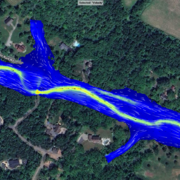
New Jersey Subbasin Paired Air & Stream Water Temperature Networks
The temperature, water quality, and channel connectivity along headwater stream networks often show highly dynamic spatiotemporal patterns that are tied to localized hydrogeologic and landcover controls. Groundwater exchanges exert a spatially discontinuous influence on streams that reflect, in part, the preferential nature of groundwater discharge as controlled by recharge, topography, and...

Barnegat Bay Restoration Science
The U.S. Geological Survey (USGS), in cooperation with the New Jersey Department of Environmental Protection (NJDEP) and other partners, is conducting an extensive, coordinated study of physical, chemical, and biological processes in the Barnegat Bay-Little Egg Harbor estuary. The study integrates findings of teams from the USGS New Jersey Water Science Center and USGS Coastal and Marine Science...

Hurricane Sandy Science, Ten-years Later
On October 29, 2012, Hurricane Sandy made landfall in New Jersey after several days of impacting the Atlantic coastline. Ten years later the impacted communities have recovered and rebuilt, and the New Jersey Water Science Center has expanded its scientific understanding of storm impacts on our state.

Current Period Statistics
The Current Period Streamflow Statistics project is computing low flow statistics for both a historic (1950-1979) and more recent (1990-2019) 30-year period. The computed statistics will provide information about streamflow changes over time and an evaluation of more recent streamflow conditions. The project will also present land-use changes, precipitation patterns, and water use in the...
StreamStats in New Jersey
StreamStats is a web application (Web Tool) for water-resources planning and engineering purposes. The map-based user interface can be used to delineate drainage areas for user-selected sites on streams, generate basin characteristics and estimate flow statistics for the selected sites. Users also can select the locations of USGS data-collection stations, shown as triangles on the StreamStats map...

New Jersey Coastal Surge, Wave, and Tide Hydrodynamics Network (SWaTH)
Following Hurricane Sandy, the USGS began construction of an overland Surge, Wave, and Tide Hydrodynamics (SWaTH) Network along the Northeastern Atlantic Coast from North Carolina to Maine. This network, developed collaboratively with numerous partners, features the integration of long-term tide gage networks, with real-time rapid-deployment gages (RDG) and mobile storm-tide sensors (STS). An...

Research and Investigations
The NJWSC conducts research and investigations related to topics such as groundwater and surface-water quality related to anthropogenic and agricultural activities, hydraulic and hydrologic modeling, tracking the movement of groundwater contamination, groundwater resource assessments and modeling, ecological assessments and response to urbanization, and estimating water-use for human and...