
Adult and juvenile beaver near Windrose, Oregon
Images
Check out photos of some of the awesome work USGS scientists and field technicians have done over the years.
Filter Total Items: 377

Adult and juvenile beaver near Windrose, Oregon
Adult and juvenile beaver near Windrose, Oregon

Phormidium, Cyanobacteria
Rock with mat of Phormidium cyanobacteria circled by "rock snot" stalked diatoms. Phormidium is common in western rivers and produces neurotoxins including anatoxins that are highly toxic to dogs, humans, and other wildlife.
Rock with mat of Phormidium cyanobacteria circled by "rock snot" stalked diatoms. Phormidium is common in western rivers and produces neurotoxins including anatoxins that are highly toxic to dogs, humans, and other wildlife.

Cyanobacteria - Dolichospermum (blue green algae)
Microscopic view of blue green algae sample. Some algae produce toxins that threaten the health and safety of living things that come in direct contact. Cyanobacteria - Dolichospermum (blue green algae)
Microscopic view of blue green algae sample. Some algae produce toxins that threaten the health and safety of living things that come in direct contact. Cyanobacteria - Dolichospermum (blue green algae)

Beaver along bank of pond in Tualatin River Basin, OR
Beaver along bank of pond in Tualatin River Basin, ORBeaver along bank of pond in Tualatin River Basin, OR
Beaver along bank of pond in Tualatin River Basin, OR
Beaver along bank of pond in Tualatin River Basin, ORBeaver along bank of pond in Tualatin River Basin, OR

Cardinal Meadowhawk
This dragonfly is called a Cardinal Meadowhawk.
This dragonfly is called a Cardinal Meadowhawk.

Algal bloom in WIllow Creek Reservoir, Oregon
Algal bloom in WIllow Creek Reservoir, Oregon, taken during a photointerpretive study of the lake.
Algal bloom in WIllow Creek Reservoir, Oregon, taken during a photointerpretive study of the lake.

Willow Creek Reservoir, Oregon
View of the Willow Creek Reservoir near Heppner, OR
View of the Willow Creek Reservoir near Heppner, OR

Beaver at Summer Lake, Oregon
Beaver swimming in Summer Lake, Oregon.
Beaver swimming in Summer Lake, Oregon.

Beaver eating at Summer Lake, OR
Beaver eating at Summer Lake, OR
Beaver eating at Summer Lake, OR

Beaver swimming in Summer Lake, OR
Beaver swimming in Summer Lake, OR
Beaver swimming in Summer Lake, OR

Rough skin newt just below the surface of a wetland pond
Rough skin newt just below the surface of a wetland pondRough skin newt just below the surface of a wetland pond in the Tualatin River Basin, Oregon.
Rough skin newt just below the surface of a wetland pond
Rough skin newt just below the surface of a wetland pondRough skin newt just below the surface of a wetland pond in the Tualatin River Basin, Oregon.

Columbia River at Stevenson, Washington
Hydrologic technician Sylas Daughtrey works at a gagehouse on Columbia River at Stevenson, Washington
Hydrologic technician Sylas Daughtrey works at a gagehouse on Columbia River at Stevenson, Washington

USGS streamgage on the Trask River
Trask River stage, discharge, and water-quality data are collected and used together to help monitor the current health of the river. Instream equipment is stored in protective housing to protect it from the elements. Data from the river are sent to equipment in the gage house, where it is stored then transmitted to USGS servers.
Trask River stage, discharge, and water-quality data are collected and used together to help monitor the current health of the river. Instream equipment is stored in protective housing to protect it from the elements. Data from the river are sent to equipment in the gage house, where it is stored then transmitted to USGS servers.

USGS Streamgage on the Williamson River
A U.S. Geological Survey hydrologist collects a water sample from the Williamson River below Chiloquin, Oregon. The sample was analyzed as part of a water-quality study the USGS conducted in cooperation with the U.S. Bureau of Reclamation and the Klamath Tribes.
A U.S. Geological Survey hydrologist collects a water sample from the Williamson River below Chiloquin, Oregon. The sample was analyzed as part of a water-quality study the USGS conducted in cooperation with the U.S. Bureau of Reclamation and the Klamath Tribes.

Views from Siuslaw National Forest, OR
Scenic view from Siuslaw National Forest, OR.

Stuck in the muck at West Fork Palmer Creek, OR
USGS scientist completing a stream assessement of West Fork Palmer Creek, Oregon.
USGS scientist completing a stream assessement of West Fork Palmer Creek, Oregon.

Tools of the trade
Photograph of field gear and equipment used in water quality monitoring.
Photograph of field gear and equipment used in water quality monitoring.

Hydrologist in the field
USGS hydrologist working in the field.
USGS hydrologist working in the field.

Willamette Valley floodplain
An agriculture field in the upper floodplain of the Willamette Valley near Junction City, Oregon.
An agriculture field in the upper floodplain of the Willamette Valley near Junction City, Oregon.
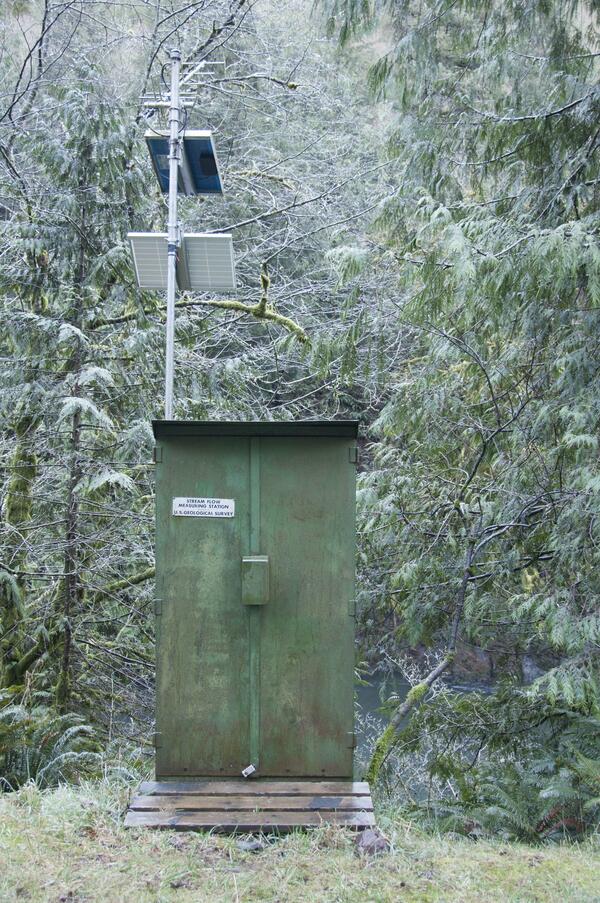
A USGS streamflow gaging station is used to collect water data
A USGS streamflow gaging station is used to collect water dataA U.S. Geological Survey streamflow gaging station collects water data on the Trask River. The Trask River gage is located near Tillamook, Ore. and has been in operation for 17 years.

USGS streamgage on the Trask River
Trask River stage, discharge, and water-quality data are collected and used together to help monitor the current health of the river. Data from the river are sent to equipment in the gage house, where it is stored then transmitted to USGS servers.
Trask River stage, discharge, and water-quality data are collected and used together to help monitor the current health of the river. Data from the river are sent to equipment in the gage house, where it is stored then transmitted to USGS servers.