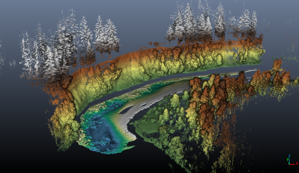
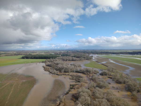
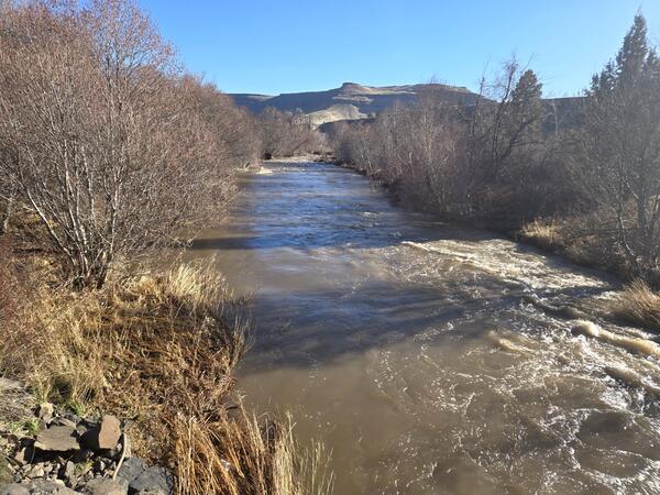
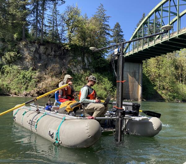
U.S. flag

An official website of the United States government

Images

Check out photos of some of the awesome work USGS scientists and field technicians have done over the years.

Filter Total Items: 349
Hammer with a red, white, and blue bow mounted on black felt canvas with a golden frame
USGS Oregon District Hammer Award

In 1996 the USGS Water Resources Division (now called Water Mission Area) received Vice President Gore's Hammer Award. It was presented by Assistant Secretary for Water and Science, Patricia Beneke, at the Carnegie Center in Oregon City, Oregon, with Dennis Lynch, District Chief, Oregon, accepting on behalf of the Division.

In 1996 the USGS Water Resources Division (now called Water Mission Area) received Vice President Gore's Hammer Award. It was presented by Assistant Secretary for Water and Science, Patricia Beneke, at the Carnegie Center in Oregon City, Oregon, with Dennis Lynch, District Chief, Oregon, accepting on behalf of the Division.

Sediment filled brown meandering river floods into nearby agricultural land. Partly cloudy day.
Aerial image of Marys River

USGS Hydrologic Technicians captured this aerial image above Marys River during the December 2025 flood event. 

USGS Hydrologic Technicians captured this aerial image above Marys River during the December 2025 flood event. 

Swollen brown river water flowing through downed trees. Two technicians in safety gear pull ADCP across the channel
Mohawk River high-flow measurement

Oregon Water Science Center Eugene Field Office Hydrologic Technicians, Ben Thorpe, Kyle Flannery, and Itziar Zandueta Lopez, measured high-flows at Mohawk River Near Springfield, OR - USGS-14165000 concurrently usin

Oregon Water Science Center Eugene Field Office Hydrologic Technicians, Ben Thorpe, Kyle Flannery, and Itziar Zandueta Lopez, measured high-flows at Mohawk River Near Springfield, OR - USGS-14165000 concurrently usin

two people standing on a foot bridge look over metal railing at measurement equipment in the creek
Chicken Creek high-flow measurement

Hydrologic technicians Adam and Vanessa make a flow measurement using an acoustic doppler current profiler (ADCP). The ADCP is tethered to a rope and is pulled across the channel so it can collect channel depth and flow velocity measurements. The technicians did a great job getting a measurement close to the peak flow at this site on December 19, 2025.

Hydrologic technicians Adam and Vanessa make a flow measurement using an acoustic doppler current profiler (ADCP). The ADCP is tethered to a rope and is pulled across the channel so it can collect channel depth and flow velocity measurements. The technicians did a great job getting a measurement close to the peak flow at this site on December 19, 2025.

brown Clackamas River flood waters reach upper boat ramp. Drowned trees line the full river in the distance.
Clackamas River high-flow survey

USGS scientist, wearing a personal protection device, or PFD, surveys water levels and debris line on the Clackamas River, Milo McIver park boat ramp. These measurements are used to validate a 2D hydraulic model of the Clackamas River.

USGS scientist, wearing a personal protection device, or PFD, surveys water levels and debris line on the Clackamas River, Milo McIver park boat ramp. These measurements are used to validate a 2D hydraulic model of the Clackamas River.

Scientist stands at the water's edge of the flooded boat ramp.
Clackamas River high-flow survey

USGS scientist, wearing a personal protection device, or PFD, surveys water levels and debris line on the Clackamas River, Milo McIver park boat ramp. These measurements are used to validate a 2D hydraulic model of the Clackamas River.

USGS scientist, wearing a personal protection device, or PFD, surveys water levels and debris line on the Clackamas River, Milo McIver park boat ramp. These measurements are used to validate a 2D hydraulic model of the Clackamas River.

Dark tan water is up to sign at flooded park
Flooded Sarah Helmick State Recreation Site along the Luckiamute River

Field technicians braved the flooded park to collect critical streamflow measurements nearby. The Luckiamute River Near Suver, OR (# 14190500) is operated in cooperation with the US Army Corps of Engineers and is a USGS Federal Priority Streamgage.

Field technicians braved the flooded park to collect critical streamflow measurements nearby. The Luckiamute River Near Suver, OR (# 14190500) is operated in cooperation with the US Army Corps of Engineers and is a USGS Federal Priority Streamgage.

water flows past trees, a downed speed limit sign, and over the road. Large rocks deposited on roadway.
Clackamas River floods Barton Park

In December 2025 USGS field crews captured photos of Clackamas River flooding at Barton Park while surveying the scale of the flood.

In December 2025 USGS field crews captured photos of Clackamas River flooding at Barton Park while surveying the scale of the flood.

brown water floods trees and is dangerously close to mobile homes along the river. Flooded trees line banks on a cloudy day.
Flood waters on the Clackamas River

High-flows on the Clackamas River seen from the Carver Bridge, in Carver Oregon.

birds eye view of a road sparsely lined with trees is surrounded by flood waters
Nearly flooded Buena Vista Road near Luckiamute River

USGS Hydrologic Technicians captured this aerial image with a drone during field. The USGS Oregon Water Science Center operates a streamflow gaging station nearby on the Luckiamute River.

USGS Hydrologic Technicians captured this aerial image with a drone during field. The USGS Oregon Water Science Center operates a streamflow gaging station nearby on the Luckiamute River.

high up view, field crew are small brightly colored figures standing on a bridge while measuring
aerial view of Mohawk River during high-flow

Oregon Water Science Center Eugene Field Office Hydrologic Technicians, Ben Thorpe, Kyle Flannery, and Itziar Zandueta Lopez, measured high-flows at Mohawk River Near Springfield, OR - USGS-14165000 concurrently usin

Oregon Water Science Center Eugene Field Office Hydrologic Technicians, Ben Thorpe, Kyle Flannery, and Itziar Zandueta Lopez, measured high-flows at Mohawk River Near Springfield, OR - USGS-14165000 concurrently usin

Female in safety gear pulls measurement equipment across the river from a bridge
Mohawk River high-flow measurement

Oregon Water Science Center Eugene Field Office Hydrologic Technician Itziar Zandueta Lopez, measuring high-flows at Mohawk River Near Springfield, OR - USGS-14165000 concurrently using an Acoustic Doppler Current Pr

Oregon Water Science Center Eugene Field Office Hydrologic Technician Itziar Zandueta Lopez, measuring high-flows at Mohawk River Near Springfield, OR - USGS-14165000 concurrently using an Acoustic Doppler Current Pr

men in safety gear stand in rushing water fixing a pipe to the river bank
Hood River at Tucker Bridge: high flow repairs

Hydrologic technicians installing temporary orifice line in the stream to restore stage readings during a rising flood. 

Hydrologic technicians installing temporary orifice line in the stream to restore stage readings during a rising flood. 

rushing river runs by snow dusted banks
Hood River at Tucker Bridge, near Hood River Oregon
A man suspended above the river operates an aluminum crane used to lower measurement equipment into the water
Nahelem River near Foss, Oregon - High flow

A skilled hydrologic technician measures high flows from a cable car over the Nehalem River near Foss, OR.

Square concrete structure built alongside the riverbank has solar power & antennas on top and wooden walkway leading to door
Nehalem River near Foss, gage house

The concrete gage house on the Nehalem River near Foss, OR. This site (# 14301000) is a USGS Federal Priority streamgage. 

A man suspended above murky rushing river waters measures flow from an aluminum cable car
Nahelem River near Foss, Oregon - High flow

A highly skilled hydrologic technician measures high flows from a cable way over the Nehalem River near Foss, OR.

A highly skilled hydrologic technician measures high flows from a cable way over the Nehalem River near Foss, OR.

technician measures
Breitenbush River Blw Breitenbush Hot Springs, OR - High Flows

A hydrologic technician measures the Breitenbush River below Breitenbush Hot Springs, OR, (# 14178610).

an orange trimaran boat on a tether
Deschutes River near Culver, Oregon - High flow

This high flow measurement on the Deschutes River near Culver, OR was the highest measurement since 2017. This site (# 14076500) is operated in cooperation with Portland General Electric.

This high flow measurement on the Deschutes River near Culver, OR was the highest measurement since 2017. This site (# 14076500) is operated in cooperation with Portland General Electric.

A technician climbs a steal dolphin to access gage equipment from a boat
Columbia River at Vancouver

A highly skilled hydrologic technician maintains monitoring equipment in the Columbia River at Vancouver, WA. They are climbing a structure called a "dolphin". In maritime terms, a dolphin is a cluster of pilings driven into the riverbed, often used for mooring or as a base for a light or sign. This dolphin also secures USGS equipment critical for flow monitoring.

A highly skilled hydrologic technician maintains monitoring equipment in the Columbia River at Vancouver, WA. They are climbing a structure called a "dolphin". In maritime terms, a dolphin is a cluster of pilings driven into the riverbed, often used for mooring or as a base for a light or sign. This dolphin also secures USGS equipment critical for flow monitoring.

Cloudy rainy day. Pine trees top brown steep muddy banks of empty reservoir with stream running through muddy channel
Green Peter Reservoir drawdown 2025

Green Peter Reservoir drawn down to a free-flowing stream channel winding through muddy sediment.

Green Peter Reservoir drawn down to a free-flowing stream channel winding through muddy sediment.

Was this page helpful?