
The eastern shore of Lake Abert, a saline lake in Oregon, photographer during a field trip USGS researchers led with multiple local groups. A drought in 2022 resulted in low water levels.
Images
Check out photos of some of the awesome work USGS scientists and field technicians have done over the years.
Filter Total Items: 377

Lake Abert, Oregon
The eastern shore of Lake Abert, a saline lake in Oregon, photographer during a field trip USGS researchers led with multiple local groups. A drought in 2022 resulted in low water levels.

Warner Lakes, Oregon
Warner Lakes in Oregon photographed from the eastern ridge looking west. In 2022 the lakes were dry due to an extended drought in the western U.S.
Warner Lakes in Oregon photographed from the eastern ridge looking west. In 2022 the lakes were dry due to an extended drought in the western U.S.

An ADCP measures the Sevenmile Canal
A YSI Sontek M9 acoustic doppler current profiler (ADCP) measures the flow along the Sevenmile Canal. The Sevenmile Canal is a tributary to Upper Klamath Lake.
A YSI Sontek M9 acoustic doppler current profiler (ADCP) measures the flow along the Sevenmile Canal. The Sevenmile Canal is a tributary to Upper Klamath Lake.

Water-quality pipes below Fall Creek Dam, Oregon
Two black stacked PVC pipes along Fall Creek house water-quality sensors. The bottom pipe has the sensors deployed at the site and the top is used to deploy reference sensors during site calibration and cleaning visits.
Two black stacked PVC pipes along Fall Creek house water-quality sensors. The bottom pipe has the sensors deployed at the site and the top is used to deploy reference sensors during site calibration and cleaning visits.

Sediment sampling
The white torpedo shaped white sediment sampler is suspended from a cable attached to a bank operated cableway.
The white torpedo shaped white sediment sampler is suspended from a cable attached to a bank operated cableway.

Ruby Lake National Wildlife Reserve
Ruby Lake National Wildlife Refuge lies at the southern end of Ruby Valley in northeast Nevada. For more information visit the Ruby Lake NWR website.
By
Ecosystems Mission Area, Water Resources Mission Area, Land Management Research Program, Water Availability and Use Science Program, Climate Adaptation Science Centers, Forest and Rangeland Ecosystem Science Center, Fort Collins Science Center, Nevada Water Science Center, Oregon Water Science Center, Utah Water Science Center, Western Ecological Research Center (WERC), Saline Lakes Ecosystems Integrated Water Availability Assessment

Klamath Lake
View of Klamath Lake as seen by a USGS Hydrologic Technician in the field. Photo provided by Justin Willhite.
View of Klamath Lake as seen by a USGS Hydrologic Technician in the field. Photo provided by Justin Willhite.

Agency Lake, Oregon
Agency Lake is the northern arm of Upper Klamath Lake connected by a narrow channel. This photo was taken near the USGS Lake level monitoring station, Agency Lake near Klamath Agency, OR - 11504300.
Agency Lake is the northern arm of Upper Klamath Lake connected by a narrow channel. This photo was taken near the USGS Lake level monitoring station, Agency Lake near Klamath Agency, OR - 11504300.

Sediment sampling at the Little North Santiam River
Sediment sampling at the Little North Santiam RiverA 4-wheel crane with a reel connected to the white torpedo shaped sediment sampler. Scientist use this, and similar setups, to collect sediment samples from across a river channel.
Sediment sampling at the Little North Santiam River
Sediment sampling at the Little North Santiam RiverA 4-wheel crane with a reel connected to the white torpedo shaped sediment sampler. Scientist use this, and similar setups, to collect sediment samples from across a river channel.

Cyanobacteria in the Santiam River
Underwater shot of cyanobacteria (green mats) clinging to rocks in the North Santiam River.
Underwater shot of cyanobacteria (green mats) clinging to rocks in the North Santiam River.

Stalked diatoms and filaments of green algae
Tan colored stalked diatoms (Cymbella janischii) and filaments of green algae (Ulothrix) cling to a boulder along the North Santiam.
Tan colored stalked diatoms (Cymbella janischii) and filaments of green algae (Ulothrix) cling to a boulder along the North Santiam.

DJI M600 drone equipped with a Nano hyperspectral sensor
DJI M600 drone equipped with a Nano hyperspectral sensorA DJI M600 drone equipped with a Nano hyperspectral sensor is prepared for flight. North Santiam River, Fishermen's Bend campground.
DJI M600 drone equipped with a Nano hyperspectral sensor
DJI M600 drone equipped with a Nano hyperspectral sensorA DJI M600 drone equipped with a Nano hyperspectral sensor is prepared for flight. North Santiam River, Fishermen's Bend campground.

North Santiam River
Photo taken during hyperspectral imaging field work on the North Santiam River, August 2021.
Photo taken during hyperspectral imaging field work on the North Santiam River, August 2021.

Filamentous Green Algae
Hairy looking Filamentous green algae clings to cobbles in the Clackamas River.
Hairy looking Filamentous green algae clings to cobbles in the Clackamas River.

Filamentous Algae coats field equipmet
USGS scientist stands next to algae covered survey equipment. The algae made its way downriver after a "sloughing event".
USGS scientist stands next to algae covered survey equipment. The algae made its way downriver after a "sloughing event".

Klamath Straits Drain
Klamath Straits Drain east of Highway 97 and F-FF pumps looking east on June 9th, 2021.
Klamath Straits Drain east of Highway 97 and F-FF pumps looking east on June 9th, 2021.

Malheur Lake field work
A mesocosm in the shallow, turbid Malheur Lake. A water-quality monitor was attached to the life ring and recorded turbidity and water temperature every 30 minutes.
A mesocosm in the shallow, turbid Malheur Lake. A water-quality monitor was attached to the life ring and recorded turbidity and water temperature every 30 minutes.
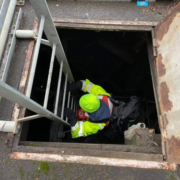
Willamette River water-quality inspection
A technician enters the bridge dolphin to inspect water-quality instruments. Water-quality sensors are cleaned routinely to ensure the highest possible quality data.
A technician enters the bridge dolphin to inspect water-quality instruments. Water-quality sensors are cleaned routinely to ensure the highest possible quality data.

Repairs at the Breitenbush River streamflow gage
When equipment goes down sometimes you must climb up. This highly skilled technician makes repairs to the rooftop solar panel. This streamflow gage was surrounded by the forest fires in 2020.
When equipment goes down sometimes you must climb up. This highly skilled technician makes repairs to the rooftop solar panel. This streamflow gage was surrounded by the forest fires in 2020.
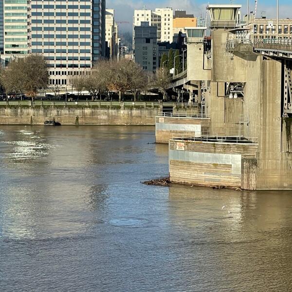
Morrison Bridge in the Willamette River, Portland
View of the Willamette River and Morrison Bridge looking across the channel towards southwest Portland.
View of the Willamette River and Morrison Bridge looking across the channel towards southwest Portland.

Cableway and stream gage on Blue River, OR
Cableway (foreground) and stream gage (background) on Blue River at Blue River, Oregon (Site number 14162200)
Cableway (foreground) and stream gage (background) on Blue River at Blue River, Oregon (Site number 14162200)