
Seven Periphyton samples from the North Santiam River, submitted for hyperspectral microscopic evaluation.
Images
Check out photos of some of the awesome work USGS scientists and field technicians have done over the years.
Filter Total Items: 377

Periphyton samples
Seven Periphyton samples from the North Santiam River, submitted for hyperspectral microscopic evaluation.

USGS Scientists gather hyperspectral and GPS data
USGS scientists gather field survey data for the periphyton hyperspectral imagery study.
USGS scientists gather field survey data for the periphyton hyperspectral imagery study.

Underwater view of periphyton
Underwater photo taken during field survey with a handheld hyperspectral senor. There is a blend of periphyton here: golden blobs of cyanobacteria (Nostoc), filaments of green algae, and small white tufts of stalked diatoms.
Underwater photo taken during field survey with a handheld hyperspectral senor. There is a blend of periphyton here: golden blobs of cyanobacteria (Nostoc), filaments of green algae, and small white tufts of stalked diatoms.

Handheld hyperspectral sensor plunges underwater
A handheld hyperspectral sensor plunges underwater to get hyperspectral signature data from periphyton on the river bed.
A handheld hyperspectral sensor plunges underwater to get hyperspectral signature data from periphyton on the river bed.

Scientists use handheld spectrometer
Scientists use an ASD handheld spectrometer to gather color spectrum data from algae coating a river cobble.
Scientists use an ASD handheld spectrometer to gather color spectrum data from algae coating a river cobble.

Rain gage and piezometer at the Klamath Marsh, Oregon
Rain gage and piezometer at the Klamath Marsh, OregonLooking south in the northern area of the Klamath Marsh. A white cylindrical rain gage that tracks rainfall and a white tube-shaped piezometer that measures changes in water level beneath the surface. These sensors are operated by the Klamath Tribes.

Irrigation pipe
Irrigation pipe on the North Santiam river supplies water to local agriculture.
Irrigation pipe on the North Santiam river supplies water to local agriculture.
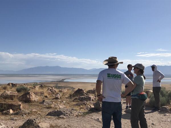
Scientist looking out onto the GSL from Antelope Island
Scientist looking out onto the GSL from Antelope IslandThese scientists are working on The Great Salt Lake to determine the amount of water and qualities of it. This will help them in developing better management techniques that will work to support the migratory birds that frequent the area.
By
Ecosystems Mission Area, Water Resources Mission Area, Species Management Research Program, Forest and Rangeland Ecosystem Science Center, Fort Collins Science Center, Nevada Water Science Center, Oregon Water Science Center, Utah Water Science Center, Western Ecological Research Center (WERC), Saline Lake Ecosystems Integrated Water Availability Assessment
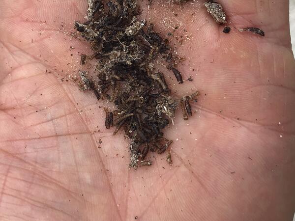
Brine fly pile
These brine flies are an important fuel source for migratory birds, giving them energy for long flights.
By
Ecosystems Mission Area, Water Resources Mission Area, Species Management Research Program, Forest and Rangeland Ecosystem Science Center, Nevada Water Science Center, Oregon Water Science Center, Utah Water Science Center, Western Ecological Research Center (WERC), Saline Lake Ecosystems Integrated Water Availability Assessment

Crystal Creek Near Rocky Point, OR
An acoustic doppler current profiler or ADCP is pulled across the channel by a hydrologic technician using the yellow tagline. An ADCP uses sound waves to measure the speed of currents throughout the water column.
An acoustic doppler current profiler or ADCP is pulled across the channel by a hydrologic technician using the yellow tagline. An ADCP uses sound waves to measure the speed of currents throughout the water column.

Groundwater level measurement
Scientists collect a routine water level depth measurement in the Klamath Falls basin-wide monitoring network.
Scientists collect a routine water level depth measurement in the Klamath Falls basin-wide monitoring network.

Drone footage above Clackamas River, Lazy Bend campground
Drone footage above Clackamas River, Lazy Bend campgroundDrone footage taken above the Clackamas River for the periphyton hyperspectral imagery study.
Drone footage above Clackamas River, Lazy Bend campground
Drone footage above Clackamas River, Lazy Bend campgroundDrone footage taken above the Clackamas River for the periphyton hyperspectral imagery study.

Mckenzie River below Sahalie Falls
Looking upstream at Mckenzie River about 0.25 miles below Sahalie Falls. OWRSC has many stream gages in this area to help out EWEB cooperators.
Looking upstream at Mckenzie River about 0.25 miles below Sahalie Falls. OWRSC has many stream gages in this area to help out EWEB cooperators.

North Santiam River
Looking up river on the North Santiam in Gates, Oregon. The small metal box houses stream monitoring telemetry equipment.
Looking up river on the North Santiam in Gates, Oregon. The small metal box houses stream monitoring telemetry equipment.

Malheur Lake, Oregon
Malheur Lake, a saline lake in eastern Oregon, photographed from a USGS airboat. USGS has been monitoring water quality parameters including temperature, turbidity, and pH in the lake since 2017.
Malheur Lake, a saline lake in eastern Oregon, photographed from a USGS airboat. USGS has been monitoring water quality parameters including temperature, turbidity, and pH in the lake since 2017.

Green Peter Dam
Water rushing down the spillway at Green Peter Dam to join the Middle Santiam River. PC: Heather Bragg, 2022.
Water rushing down the spillway at Green Peter Dam to join the Middle Santiam River. PC: Heather Bragg, 2022.

Rain gage and piezometer at the Klamath Marsh, Oregon
Rain gage and piezometer at the Klamath Marsh, OregonLooking south in the northern area of the Klamath Marsh. A white cylindrical rain gage that tracks rainfall and a white tube-shaped piezometer that measures changes in water level beneath the surface. These sensors are operated by the Klamath Tribes.

Instrument pipes at 14186200 below Green Peter Dam
Instrument pipes at 14186200 below Green Peter DamPVC pipes housing total dissolved gas sensor cables at the Santiam River below Green Peter Dam. PC: Heather Bragg, 2022.
Instrument pipes at 14186200 below Green Peter Dam
Instrument pipes at 14186200 below Green Peter DamPVC pipes housing total dissolved gas sensor cables at the Santiam River below Green Peter Dam. PC: Heather Bragg, 2022.

Conceptualization of the factors that affect groundwater recharge in oceanic islands.
Conceptualization of the factors that affect groundwater recharge in oceanic islands.Conceptualization of the factors that affect groundwater recharge in oceanic islands.
Conceptualization of the factors that affect groundwater recharge in oceanic islands.
Conceptualization of the factors that affect groundwater recharge in oceanic islands.Conceptualization of the factors that affect groundwater recharge in oceanic islands.

14149011 TDG gage at MF Willamette below Lookout Point reservoir
14149011 TDG gage at MF Willamette below Lookout Point reservoirPhoto of water quality gage in the Middle Fork Willamette River below Lookout Point Dam. Gage monitors total dissolved gas and barometric pressure. PC: Heather Bragg, 2022.

Lake Abert, Oregon
The eastern shore of Lake Abert, a saline lake in Oregon, photographer during a field trip USGS researchers led with multiple local groups. A drought in 2022 resulted in low water levels.
The eastern shore of Lake Abert, a saline lake in Oregon, photographer during a field trip USGS researchers led with multiple local groups. A drought in 2022 resulted in low water levels.