
Microcyctis aeruginosa is a freshwater cyanobacteria that produce cyanotoxins such as Microcystin. Cyanotoxins are harmful to humans and pets.
Images
Check out photos of some of the awesome work USGS scientists and field technicians have done over the years.
Filter Total Items: 377

Microcystis aeruginosa under the microscope
Microcyctis aeruginosa is a freshwater cyanobacteria that produce cyanotoxins such as Microcystin. Cyanotoxins are harmful to humans and pets.

Water level and temperature sensor in the Middle Santiam River
Water level and temperature sensor in the Middle Santiam RiverNew USGS water temperature and water level gage installed in Middle Santiam River in the Middle Santiam Wildness Area upstream of Green Peter Dam. This gage will help characterize habitat conditions for multiple life stages of spring Chinook salmon in this river reach.

North Santiam - Field Work
Brandon Overstreet paddles North Santiam River near Narrows Rapid collecting survey data and underwater photographs to characterize channel bed topography and substrates
Brandon Overstreet paddles North Santiam River near Narrows Rapid collecting survey data and underwater photographs to characterize channel bed topography and substrates

Preliminary topobathymetric digital elevation model of the Santiam River, OR.
Preliminary topobathymetric digital elevation model of the Santiam River, OR.Image of a preliminary topobathymetric digital elevation model captured of the of the Santiam River, OR.
Preliminary topobathymetric digital elevation model of the Santiam River, OR.
Preliminary topobathymetric digital elevation model of the Santiam River, OR.Image of a preliminary topobathymetric digital elevation model captured of the of the Santiam River, OR.

American coot nest in Malheur Lake
An American coot nest in Malheur Lake was built with bulrush and floated on the surface even as waves passed by.
An American coot nest in Malheur Lake was built with bulrush and floated on the surface even as waves passed by.

The Diatom Synedra under the Microscope
Diatom, Synedra, from the Greek word synedria meaning "a sitting together". The genus Synedra has long, needle like cells that can exist singly or radiate in colonies.
Diatom, Synedra, from the Greek word synedria meaning "a sitting together". The genus Synedra has long, needle like cells that can exist singly or radiate in colonies.

Willamette River near Harrisburg, Oregon
Photo taken of the Willamette River near Harrisburg, Oregon during the "heat dome" of 2021. This historic heatwave occurred in Oregon and the greater Pacific Northwest in late June of 2021 breaking high temperature records, some by several degrees.
Photo taken of the Willamette River near Harrisburg, Oregon during the "heat dome" of 2021. This historic heatwave occurred in Oregon and the greater Pacific Northwest in late June of 2021 breaking high temperature records, some by several degrees.

Walking the shallows of Lake Abert, Oregon
Lake Abert, Oregon is one of the 20 terminal lakes identified by USGS partners as priority ecosystems for study by the Saline Lakes Ecosystems IWAA.
By
Ecosystems Mission Area, Water Resources Mission Area, Species Management Research Program, Water Availability and Use Science Program, Forest and Rangeland Ecosystem Science Center, Fort Collins Science Center, Nevada Water Science Center, Oregon Water Science Center, Utah Water Science Center, Western Ecological Research Center (WERC), Saline Lake Ecosystems Integrated Water Availability Assessment

Avocets flying above Farmington Bay Wildlife Management Area, Utah
Avocets flying above Farmington Bay Wildlife Management Area, UtahThe Saline Lake Ecosystems IWAA Waterbird Movement Project began tagging American Avocets in March 2023 to track their movements across the landscape. Tracking data from these birds will help scientists better understand why these birds choose to use the terminal lake and wetland habitats they do in the Great Basin.
By
Ecosystems Mission Area, Water Resources Mission Area, Species Management Research Program, Water Resources Research Act Program, Forest and Rangeland Ecosystem Science Center, Fort Collins Science Center, Nevada Water Science Center, Oregon Water Science Center, Utah Water Science Center, Western Ecological Research Center (WERC), Saline Lake Ecosystems Integrated Water Availability Assessment
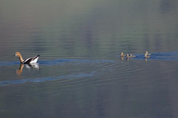
American Avocet trailed by chicks
American Avocet are a bird that relies heavily on the Saline Lakes ecosystem during their spring migration periods. Over 50% of these birds exist here. Part of their use includes using the terminal lakes there to breed.
By
Ecosystems Mission Area, Water Resources Mission Area, Species Management Research Program, Forest and Rangeland Ecosystem Science Center, Fort Collins Science Center, Nevada Water Science Center, Oregon Water Science Center, Utah Water Science Center, Western Ecological Research Center (WERC), Saline Lake Ecosystems Integrated Water Availability Assessment

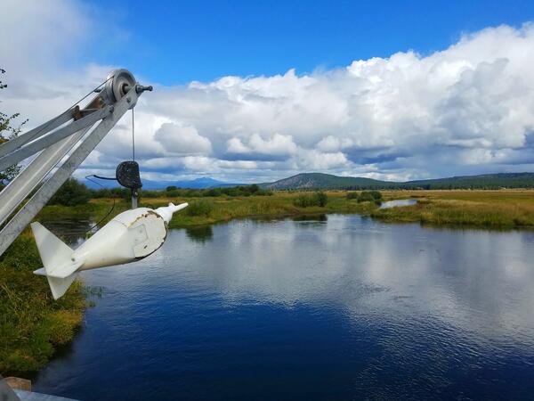
Quartzville Creek near Cascadia Oregon
An outside gage set-up at Quartzville Creek near Cascadia Oregon. Graduated staff plates installed at various heights to capture the range in water levels. Staffs are used to get river level readings hydrologic technicians need to calibrate electronic sensors. The vertical grey metal pipe is a crest stage gage (CSG).
An outside gage set-up at Quartzville Creek near Cascadia Oregon. Graduated staff plates installed at various heights to capture the range in water levels. Staffs are used to get river level readings hydrologic technicians need to calibrate electronic sensors. The vertical grey metal pipe is a crest stage gage (CSG).

Lake Abert
Photo taken by hydrotech Josh Price while he scouts for potential spots to install the new monitoring equipment.
Photo taken by hydrotech Josh Price while he scouts for potential spots to install the new monitoring equipment.

Lake Abert Gage Equipment
This large basalt boulder is the perfect stable foundation for the metal gage box keeping our equipment safe on the shores of Lake Abert.
This large basalt boulder is the perfect stable foundation for the metal gage box keeping our equipment safe on the shores of Lake Abert.

Technicians pose by newly installed monitoring equipment
Technicians pose by newly installed monitoring equipmentUSGS hydrologic technicians pose during their fastening the grey enclosure to the dock. The grey enclosure protects the monitoring station equipment from the elements.
Technicians pose by newly installed monitoring equipment
Technicians pose by newly installed monitoring equipmentUSGS hydrologic technicians pose during their fastening the grey enclosure to the dock. The grey enclosure protects the monitoring station equipment from the elements.

Data technicians install monitoring station at OMSI
Data technicians install monitoring station at OMSIUSGS data technicians are skilled in both field hydrology and construction to build and maintain USGS monitoring stations. Here they attach the equipment shelter to the dock at the Oregon Museum of Science and Industry.

Asterionella and Fragilaria under the microscope
The star-shaped Asterionella is a genus of freshwater diatoms often found in star-shaped colonies of individuals. The thread like shape is Fragilaria a genus of fresh and saltwater diatom.
The star-shaped Asterionella is a genus of freshwater diatoms often found in star-shaped colonies of individuals. The thread like shape is Fragilaria a genus of fresh and saltwater diatom.

Malheur Lake airboat crew
Scientific studies in Malheur Lake require strong partnerships and collaboration among USGS, USFWS, and High Desert Partnership. Photo by Brandon McMullen.
Scientific studies in Malheur Lake require strong partnerships and collaboration among USGS, USFWS, and High Desert Partnership. Photo by Brandon McMullen.

Applying sand to Malheur Lake mesocosm
Local sand was applied to some mesocosms to test whether hardening the lakebed would reduce suspension of bottom sediments.
Local sand was applied to some mesocosms to test whether hardening the lakebed would reduce suspension of bottom sediments.
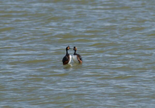
Eared grebes engaged in a courtship behavior
Eared grebes in a courtship behavior in the Great Salt Lake. They are one of many migratory birds in the Great Basin that rely on terminal lakes and wetlands in the area to stop rest and feed.
By
Ecosystems Mission Area, Water Resources Mission Area, Species Management Research Program, Forest and Rangeland Ecosystem Science Center, Fort Collins Science Center, Oregon Water Science Center, Utah Water Science Center, Western Ecological Research Center (WERC), Saline Lake Ecosystems Integrated Water Availability Assessment

Wave reduction barriers and a wind sensor in Malheur Lake
Wave reduction barriers and a wind sensor in Malheur LakeWave reduction barriers were installed around some mesocosms to test whether reducing wind-wave action would reduce suspended sediment in the water column.
Wave reduction barriers and a wind sensor in Malheur Lake
Wave reduction barriers and a wind sensor in Malheur LakeWave reduction barriers were installed around some mesocosms to test whether reducing wind-wave action would reduce suspended sediment in the water column.