
Hydrologic technician Jay Spillum digging out the Bull Run Lake gage from about 14 ft. of snow. In this photo the satellite antenna is just becoming visible, and down below that the top of the gage building. He had help, not pictured is hydrotech Scott Deweese.
Images
Check out photos of some of the awesome work USGS scientists and field technicians have done over the years.
Filter Total Items: 377

Jay Spillum digging out Bull Run Lake gage
Hydrologic technician Jay Spillum digging out the Bull Run Lake gage from about 14 ft. of snow. In this photo the satellite antenna is just becoming visible, and down below that the top of the gage building. He had help, not pictured is hydrotech Scott Deweese.

Sampling sediment transport during Marmot Dam removal, Sandy River, OR
Sampling sediment transport during Marmot Dam removal, Sandy River, ORUSGS scientists sampled sediment transport during (and after) the breaching of the Marmot Dam on the Sandy River, OR.
Sampling sediment transport during Marmot Dam removal, Sandy River, OR
Sampling sediment transport during Marmot Dam removal, Sandy River, ORUSGS scientists sampled sediment transport during (and after) the breaching of the Marmot Dam on the Sandy River, OR.

Crooked River at Smith Rocks
Crooked River of the Deschutes River Basin, Oregon, flows through Smith Rocks
Crooked River of the Deschutes River Basin, Oregon, flows through Smith Rocks

Stargrass
Water stargrass beds in the Yakima River near Kiona, Washington, when the water was clear, and turbidity values were about zero.
Water stargrass beds in the Yakima River near Kiona, Washington, when the water was clear, and turbidity values were about zero.

Timothy Lake Algal Bloom
Anabena algal bloom in Timothy Lake, Oregon, 2004
Anabena algal bloom in Timothy Lake, Oregon, 2004

Roaring Spring on the McKenzie River, Oregon
Roaring Spring on the McKenzie River, Oregon

Crater Lake, Oregon
USGS scientist collecting samples at Crater Lake, Oregon.
USGS scientist collecting samples at Crater Lake, Oregon.

High water sign on Tualatin River, OR
Lower Tualatin River near Cook Park, OR. Signage on the top of the wood pole shows high water line of the 1996 flood.
Lower Tualatin River near Cook Park, OR. Signage on the top of the wood pole shows high water line of the 1996 flood.
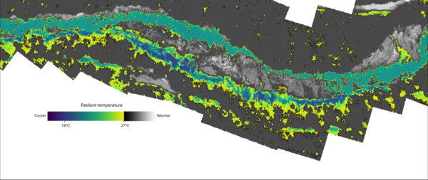
Thermal infrared mosaic of Quartzville Creek, OR
Thermal infrared mosaic of Quartzville Creek, OR. These images were captured on the year 2000 as part of an airborne thermal infrared survey conducted in the Santiam River basin, OR. The images were orthorectified and mosaicked into a single raster in order to identify and visualize thermal heterogeneity.
Thermal infrared mosaic of Quartzville Creek, OR. These images were captured on the year 2000 as part of an airborne thermal infrared survey conducted in the Santiam River basin, OR. The images were orthorectified and mosaicked into a single raster in order to identify and visualize thermal heterogeneity.

1996 Flood: Nehalem River near Foss, Oregon
When Karl Lee and Mark Uhrich arrived to make a flow measurement, they found that the high-water left behind a significant debris pile at the Nehalem River near Foss, Oregon gage house.
When Karl Lee and Mark Uhrich arrived to make a flow measurement, they found that the high-water left behind a significant debris pile at the Nehalem River near Foss, Oregon gage house.
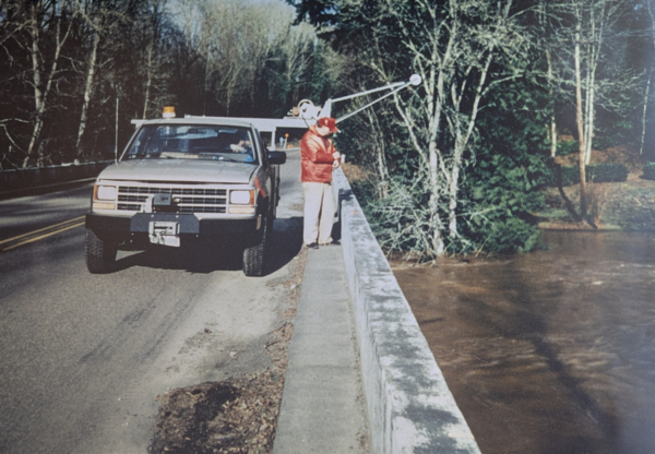
Historic photo of Tualatin River at West Linn
USGS technicians, Len Reed and Mike DeVolder, measuring the flood peak on the Tualatin River at West Linn on February 10, 1996.
USGS technicians, Len Reed and Mike DeVolder, measuring the flood peak on the Tualatin River at West Linn on February 10, 1996.
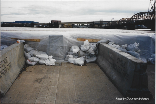
1996: Temporary levee dubbed "Vera's Wall"
In February 1996, as the Willamette River threatened downtown Portland, Mayor Vera Katz rallied over 1,500 volunteers to build "Vera's Wall". This mile-long, four-foot-high temporary levee, made of 40,000 sandbags, plywood, and jersey barriers, was hastily constructed atop the existing seawall in just 24 hours and successfully held back the floodwaters.
In February 1996, as the Willamette River threatened downtown Portland, Mayor Vera Katz rallied over 1,500 volunteers to build "Vera's Wall". This mile-long, four-foot-high temporary levee, made of 40,000 sandbags, plywood, and jersey barriers, was hastily constructed atop the existing seawall in just 24 hours and successfully held back the floodwaters.

1996 flood: Willamette Falls, Oregon City
Willamette Falls during the February 1996 flood. The falls, usually about 12 meters high in a horseshoe shape, were reduced to a small riffle.
Willamette Falls during the February 1996 flood. The falls, usually about 12 meters high in a horseshoe shape, were reduced to a small riffle.
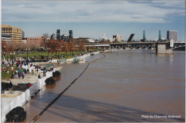
1996 Flood: Willamette River Portland Waterfront
A 1996 flood photo depicts the swollen Willamette River at Tom McCall Waterfront Park in downtown Portland, Oregon, during the region's most destructive flood since 1964. The left side shows a wall of sandbags, wood, and jersey barriers, successfully protecting the downtown area. Iconic city bridges span the background.
A 1996 flood photo depicts the swollen Willamette River at Tom McCall Waterfront Park in downtown Portland, Oregon, during the region's most destructive flood since 1964. The left side shows a wall of sandbags, wood, and jersey barriers, successfully protecting the downtown area. Iconic city bridges span the background.

1996 Flood: Portland's Steel Bridge
This photo shows the Willamette River at its peak flood stage in February 1996, a major event for the Pacific Northwest. The river reached the very bottom of the Steel Bridge's lower deck, leading to the bridge being closed to all traffic as a safety precaution for nearly 48 hours.
This photo shows the Willamette River at its peak flood stage in February 1996, a major event for the Pacific Northwest. The river reached the very bottom of the Steel Bridge's lower deck, leading to the bridge being closed to all traffic as a safety precaution for nearly 48 hours.

Historic photo of field work, Columbia River near The Dalles
Historic photo of field work, Columbia River near The DallesOld school USGS technician operates a truck mounted crane during field work in the 1970's.
Historic photo of field work, Columbia River near The Dalles
Historic photo of field work, Columbia River near The DallesOld school USGS technician operates a truck mounted crane during field work in the 1970's.

Hand drawn monitoring station sketch
Before computers and smart phones USGS needed to employ artists for field work plans and other diagrams. Some scientists and technicians were artists themselves. This beautifully hand drawn site sketch shows the layout of the Columbia River at The Dalles monitoring station and the original acoustic streamflow measurement system, a first of its kind.
Before computers and smart phones USGS needed to employ artists for field work plans and other diagrams. Some scientists and technicians were artists themselves. This beautifully hand drawn site sketch shows the layout of the Columbia River at The Dalles monitoring station and the original acoustic streamflow measurement system, a first of its kind.

Columbia River docks in 1970
USGS field crews load up their boat with equipment on the docks of the Columbia River
USGS field crews load up their boat with equipment on the docks of the Columbia River

USGS staff boating on the Columbia River
Two USGS staff boat during field work on the Columbia River near The Dalles Dam.
Two USGS staff boat during field work on the Columbia River near The Dalles Dam.

A truly epic cableway
Built-in 1937 with funds from the U.S. Army Corps of Engineers, the 100 feet tall steel tower had a main cable that stretched 1,727 feet across the Columbia. Streamflow measurements started as soon as it was daylight to avoid the highest winds.
Built-in 1937 with funds from the U.S. Army Corps of Engineers, the 100 feet tall steel tower had a main cable that stretched 1,727 feet across the Columbia. Streamflow measurements started as soon as it was daylight to avoid the highest winds.