
Data Collection Field Offices
Data Collection Field Offices
Research and projects done by our data collection field offices.
Filter Total Items: 8
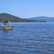
The Klamath Falls Field Office
The Oregon Water Science Center’s Klamath Falls Field Office provides surface-water and water-quality data to support the basin’s most pressing water-resource and ecosystem needs.

Water-quality monitoring during reservoir drawdowns
The USGS is monitoring water-quality above, within, and below Middle Fork Willamette and the South Santiam River dams using field-based and remote-sensing approaches to understand how reservoir drawdowns influence downstream water-quality conditions.
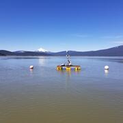
The “Super Monitor”: Tracking Willamette River water quality in Portland
Nicknamed the ‘Super Monitor,’ this site has measured key water-quality values every 15 minutes since 2009.
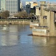
Measuring Willamette River streamflow in Portland
Learn about one of Oregon's most relied upon streamflow gages.

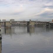
Willamette River Data Comes to Life Through Bridge Lighting
Did you know the colorful lighting on the Tilikum Crossing, Bridge of the People, is synced with U.S. Geological Survey water data from the Willamette River?
Integrating water availability in the Klamath Basin: from drought to dam removal
The USGS Water Resources Mission Area is assessing how much water is available for human and ecological needs in the United States and identifying where and when the Nation may have challenges meeting its demand for water. This information helps decision makers manage and distribute water in ways that balance competing needs. Due to its complex and competing water demands, ecological significance...

Evaluating sediment transport in Chicken Creek
The United States Geological Survey (USGS) is evaluating how the newly restored meandering channel on Chicken Creek affects sediment transport within the Tualatin River National Wildlife Refuge.

Bridge scour monitoring in Oregon
The U.S. Geological Survey is working with the Oregon Department of Transportation (ODOT) and Federal Highway Administration (FHWA) to revolutionize bridge scour monitoring using real-time sonar data collection and bathymetric surveying to remotely monitor sites, collect long-term data for evaluation, and develop and improve hydraulic models that predict scour.