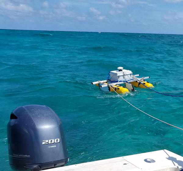
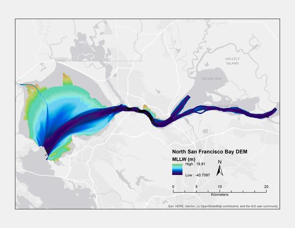
U.S. flag

An official website of the United States government

Images

Pacific Coastal and Marine Science Center images.

Filter Total Items: 1358
Four photos show scientists working in the field collecting data using various methods.
Field work in the Columbia River Littoral Cell

Photographs showing equipment used during bathymetric and topographic surveys along the Columbia River littoral cell, Washington and Oregon.

A series of panels, looking down at a river delta, show how the delta changed, growing larger as more sediment flowed downriver.
Evolution of shoreline around Elwha River mouth

Evolution of the shoreline around the Elwha River mouth, Washington, before, during and after dam removal, 2011–2017. Two large dams were removed from the Elwha River between 2011 and 2014 in the largest dam removal worldwide thus far, releasing more than 20 million tons of sediment downstream.

Evolution of the shoreline around the Elwha River mouth, Washington, before, during and after dam removal, 2011–2017. Two large dams were removed from the Elwha River between 2011 and 2014 in the largest dam removal worldwide thus far, releasing more than 20 million tons of sediment downstream.

Two men work on a boat pulling up a long cable from the water.
Retrieving a core sampler

USGS scientists Dan Powers (left) and Andy Ritchie retrieving a core sample from beneath Lake Ozette aboard research vessel Hadai.

USGS scientists Dan Powers (left) and Andy Ritchie retrieving a core sample from beneath Lake Ozette aboard research vessel Hadai.

Collage of images showing the area of study with underwater photographs of the seafloor and dots on the map to show photo locations.
squid-5StudyAreaMap.jpg

Image map of study area showing (a) study region, (b) study sites, (c, d) example orthomosaic images, and (e) photo of SET 1.

Illustration helps visualize the seafloor character offshore of the continental United States showing canyons and other features
Astoria Canyon multibeam bathymetry

Multibeam bathymetry shown in the spectrum from red (shallower) to blue (deeper) for depths greater than 200 m across the head of Astoria Canyon. The land and continental shelf are shown in grayscale slope shading where darker colors represent steeper slopes.  The modern Columbia River is far right.

Multibeam bathymetry shown in the spectrum from red (shallower) to blue (deeper) for depths greater than 200 m across the head of Astoria Canyon. The land and continental shelf are shown in grayscale slope shading where darker colors represent steeper slopes.  The modern Columbia River is far right.

Illustration helps visualize the seafloor character showing canyons and and the rivers that form them.
Southern Cascadia topography and bathymetry

Topography and bathymetry of southern Cascadia, which includes southern Oregon and northern California (seafloor depths between 200 and 3000 m are shown in the spectrum color scale from red (shallower) to purple (deeper). The land and continental shelf are shown in grayscale slope shading where darker colors represent steeper slopes.

Topography and bathymetry of southern Cascadia, which includes southern Oregon and northern California (seafloor depths between 200 and 3000 m are shown in the spectrum color scale from red (shallower) to purple (deeper). The land and continental shelf are shown in grayscale slope shading where darker colors represent steeper slopes.

Photo of 2019 Ozette Lake fieldwork and bathymetric map showing core locations

Photo of 2019 Ozette Lake fieldwork (USGS scientists Dan Powers and Andy Ritchie retrieving a core sample aboard research vessel Hadai) and bathymetric map showing core locations.

Photograph of 2 UNC mini landers surrounded by Sablefish
UNC mini landers surrounded by Sablefish

 Two UNC mini landers, surrounded by Sablefish (Anoplopoma fimbria) and pink sea urchins, incubate seawater in situ to enable calculations of methane oxidation rates.

Photograph of Red plumes burst out from the tops of these chemosynthetic tubeworms
Red plumes burst out from the tops of these chemosynthetic tubeworms

Red plumes burst out from the tops of these chemosynthetic tubeworms, capturing hydrogen sulfide and oxygen from the surrounding water to feed their bacterial endosymbionts. The tubeworm tubes provide a habitat for several benthic animals, including the pale pink branching octocorals seen here

Red plumes burst out from the tops of these chemosynthetic tubeworms, capturing hydrogen sulfide and oxygen from the surrounding water to feed their bacterial endosymbionts. The tubeworm tubes provide a habitat for several benthic animals, including the pale pink branching octocorals seen here

An illustrated map shows seafloor features and is labeled with dots to show where samples were collected.
Lake Ozette bathymetry

Bathymetric map of Lake Ozette, showing locations of core samples (red circles).

Bathymetric map of Lake Ozette, showing locations of core samples (red circles).

Two men walk along a path near one building towards another building with trees and a grassy lawn.
Building 1 and Credit Union on USGS Menlo Park campus

Building 1 formerly housed many different USGS groups, including the Western Coastal and Marine Geology team, but slowly has been leased out to other federal agencies like the Transportation Security Administration (TSA) and Veterans Affairs (VA). At the right is the Menlo Survey Federal Credit Union.

Building 1 formerly housed many different USGS groups, including the Western Coastal and Marine Geology team, but slowly has been leased out to other federal agencies like the Transportation Security Administration (TSA) and Veterans Affairs (VA). At the right is the Menlo Survey Federal Credit Union.

Photograph of a building in the distance with a flagpole in front of it, trees, cars parked, and grassy lawn in the foreground.
USGS Menlo Park campus

Building 3 on the USGS Western Region campus in Menlo Park, California.

Building 3 on the USGS Western Region campus in Menlo Park, California.

Dr. Barnard
Dr. Barnard
Dr. Barnard
Dr. Barnard

As one of four panelists at a briefing held by the Environmental and Energy Study Institute (EESI) and the Coastal States Organization, Dr.

As one of four panelists at a briefing held by the Environmental and Energy Study Institute (EESI) and the Coastal States Organization, Dr.

A coil of green hose on the deck of a ship at sea.
Geometrics GeoEel Multichannel Streamer

PCMSC's Geometrics GeoEel Multichannel Streamer sits on the deck of R/V Bold Horizon

An instrument rests on the deck of a ship, its cables suspended above it, while a scientist looks on.
Chirp rests on the deck of R/V Bold Horizon

This instrument, the Edgetech SB-516 or "chirp", emits acoustic signals that penetrate the sediment on the seafloor. The reflected sound is recorded and is used to create a cross-section image, or profile, of the sub-bottom.

This instrument, the Edgetech SB-516 or "chirp", emits acoustic signals that penetrate the sediment on the seafloor. The reflected sound is recorded and is used to create a cross-section image, or profile, of the sub-bottom.

Photo of the side of a ship docked at a pier with a bridge far off in the distance.
NOAA ship Reuben Lasker

NOAA ship Reuben Lasker docked in San Francisco with the Bay Bridge in the distance. On October 21, leadership from NOAA, USGS, and BOEM met with the scientists and crew of the EXPRESS expedition to learn about the multi-agency cooperative research campaign.

NOAA ship Reuben Lasker docked in San Francisco with the Bay Bridge in the distance. On October 21, leadership from NOAA, USGS, and BOEM met with the scientists and crew of the EXPRESS expedition to learn about the multi-agency cooperative research campaign.

View from up high on a coastal cliff looking down along a beach where a river meets the ocean.
Klamath River mouth
Klamath River mouth
Klamath River mouth

A view of the mouth of the Klamath River where it meets the Pacific Ocean in northern California. The river runs from Oregon to California. Four dams along the Klamath are pending removal. USGS is studying coastal watershed response to dam removal, including long-term before-after/control-impact (BACI) studies.

A view of the mouth of the Klamath River where it meets the Pacific Ocean in northern California. The river runs from Oregon to California. Four dams along the Klamath are pending removal. USGS is studying coastal watershed response to dam removal, including long-term before-after/control-impact (BACI) studies.

People standing on the stern of a boat out in open, calm water, sun low in the sky behind clouds.
Retrieving gear from off the coast

A science crew on M/V (marine vessel) Bold Horizon retrieve gear from offshore San Francisco.

Was this page helpful?