
The Southwest Biological Science Center:
Providing Unbiased Actionable Science & Information to Support Natural Resource Management Needs of the U.S. & Department of the Interior Priorities
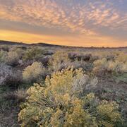
The Southwest Fire Innovation Landscape Network
Advanced tools for fuel monitoring and assessment of wildfire risk
Early detection of aquatic threats
eDNA research in the Colorado River ecosystem & Lake Powell
A new app to report flash floods and debris flows in Grand Canyon
New backcountry alert system for the Grand Canyon
Visitors can subscribe to the alert system using satellite communication devices
Supporting energy and mineral development through successful reclamation
Southwest Biological Science Center
The SBSC provides sound science, specialized expertise, and objective and timely tools to Federal and State agencies and the public to inform land management decision-making, and support thriving landscapes for the Southwest’s abundant natural resources and vast public lands. This research assists those who manage, conserve, and rehabilitate rivers and arid regions of the nation.
Dryland Ecology and Management Support: our Terrestrial Drylands Ecology branch

SBSC conducts research in terrestrial drylands to deliver information that aids land & wildlife management to promote productive ecosystems. Our work provides tools used to mitigate impacts of drought, wildfire, and invasive species, as well as science that supports Department of the Interior economic and cultural activities including recreation and ranching.
Grand Canyon Monitoring and Research Center & Lake Powell research: our River Ecosystems branch

The SBSC Rivers branch, which includes the Grand Canyon Monitoring & Research Center, studies the biology, ecology, and processes of rivers, primarily in the SW. We provide the public and decision makers with relevant scientific information about the status and trends of natural, cultural, and recreational resources of the Colorado River in Grand Canyon, and Lake Powell.
Quick Links
- Learn how SBSC supports DOI priorities
- GCMRC-specific publications: A resource for GCDAMP stakeholders
- SBSC initiatives support ecosystems & economies on the Colorado Plateau
- Restoration Assessment & Monitoring Program for the Southwest (RAMPS)
- The Southwest Repeat Photography Collection
- Our Staff Directory
News
A Tale of Two Islands and the Future of an Ocean Sentinel Seabird
Tree rings provide an important multi-century context for the current wildfire crisis
Amphibian Week with USGS: Science for Healthy Habitats
Publications
Continuous and high-resolution longitudinal profiles of the water surface and riverbed elevation for 282 miles of the Colorado River from Lees Ferry to Pearce Ferry, Arizona, 2021 Continuous and high-resolution longitudinal profiles of the water surface and riverbed elevation for 282 miles of the Colorado River from Lees Ferry to Pearce Ferry, Arizona, 2021
High-resolution transboundary vegetation community maps of the Sonoran and Mojave Desert ecoregion to support critical landscape conservation planning and habitat management needs High-resolution transboundary vegetation community maps of the Sonoran and Mojave Desert ecoregion to support critical landscape conservation planning and habitat management needs
Whatever it takes— Shaping the L&O Letters Early Career Publication Honor to deliver true benefit Whatever it takes— Shaping the L&O Letters Early Career Publication Honor to deliver true benefit
Science

Copper mining, critical minerals, and long-term drought in the Southwest United States
Enhancing Rangeland Recovery by Forecasting Seed Establishment
